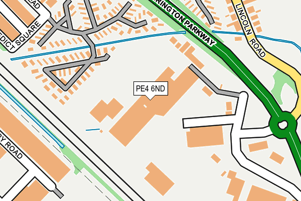
PE4 6ND is located in the Paston and Walton electoral ward, within the unitary authority of Peterborough and the English Parliamentary constituency of Peterborough. The Sub Integrated Care Board (ICB) Location is NHS Cambridgeshire and Peterborough ICB - 06H and the police force is Cambridgeshire. This postcode has been in use since September 1981.


GetTheData
Source: OS OpenMap – Local (Ordnance Survey)
Source: OS VectorMap District (Ordnance Survey)
Licence: Open Government Licence (requires attribution)
| Easting | 516689 |
| Northing | 302627 |
| Latitude | 52.608898 |
| Longitude | -0.278185 |
GetTheData
Source: Open Postcode Geo
Licence: Open Government Licence
| Country | England |
| Postcode District | PE4 |
➜ See where PE4 is on a map ➜ Where is Peterborough? | |
GetTheData
Source: Land Registry Price Paid Data
Licence: Open Government Licence
Elevation or altitude of PE4 6ND as distance above sea level:
| Metres | Feet | |
|---|---|---|
| Elevation | 10m | 33ft |
Elevation is measured from the approximate centre of the postcode, to the nearest point on an OS contour line from OS Terrain 50, which has contour spacing of ten vertical metres.
➜ How high above sea level am I? Find the elevation of your current position using your device's GPS.
GetTheData
Source: Open Postcode Elevation
Licence: Open Government Licence
| Ward | Paston And Walton |
| Constituency | Peterborough |
GetTheData
Source: ONS Postcode Database
Licence: Open Government Licence
| Mancetter Square (Lincoln Road) | Walton | 232m |
| Dukesmead (Werrington Parkway) | Werrington | 284m |
| Mancetter Square (Lincoln Road) | Walton | 298m |
| Coningsby Road | North Bretton | 301m |
| Dukesmead (Werrington Parkway) | Werrington | 306m |
| Peterborough Station | 4.2km |
GetTheData
Source: NaPTAN
Licence: Open Government Licence
GetTheData
Source: ONS Postcode Database
Licence: Open Government Licence


➜ Get more ratings from the Food Standards Agency
GetTheData
Source: Food Standards Agency
Licence: FSA terms & conditions
| Last Collection | |||
|---|---|---|---|
| Location | Mon-Fri | Sat | Distance |
| Dukesmead | 18:45 | 13:15 | 232m |
| Stirling Way | 17:45 | 12:15 | 419m |
| Church Street | 17:45 | 12:30 | 474m |
GetTheData
Source: Dracos
Licence: Creative Commons Attribution-ShareAlike
| Risk of PE4 6ND flooding from rivers and sea | Medium |
| ➜ PE4 6ND flood map | |
GetTheData
Source: Open Flood Risk by Postcode
Licence: Open Government Licence
The below table lists the International Territorial Level (ITL) codes (formerly Nomenclature of Territorial Units for Statistics (NUTS) codes) and Local Administrative Units (LAU) codes for PE4 6ND:
| ITL 1 Code | Name |
|---|---|
| TLH | East |
| ITL 2 Code | Name |
| TLH1 | East Anglia |
| ITL 3 Code | Name |
| TLH11 | Peterborough |
| LAU 1 Code | Name |
| E06000031 | Peterborough |
GetTheData
Source: ONS Postcode Directory
Licence: Open Government Licence
The below table lists the Census Output Area (OA), Lower Layer Super Output Area (LSOA), and Middle Layer Super Output Area (MSOA) for PE4 6ND:
| Code | Name | |
|---|---|---|
| OA | E00079280 | |
| LSOA | E01015676 | Peterborough 006C |
| MSOA | E02003242 | Peterborough 006 |
GetTheData
Source: ONS Postcode Directory
Licence: Open Government Licence
| PE4 6LA | Lincoln Road | 112m |
| PE4 6LE | Lincoln Road | 260m |
| PE4 6LF | Lincoln Road | 270m |
| PE4 6NS | Helmsdale Gardens | 282m |
| PE4 6LQ | Lincoln Road | 309m |
| PE4 6ZN | Dukesmead Industrial Estate | 311m |
| PE3 8SB | The Thomas Cook Business Park | 344m |
| PE4 6LJ | Lincoln Road | 344m |
| PE3 8AF | Mallard Road | 371m |
| PE4 6LL | Lincoln Road | 377m |
GetTheData
Source: Open Postcode Geo; Land Registry Price Paid Data
Licence: Open Government Licence