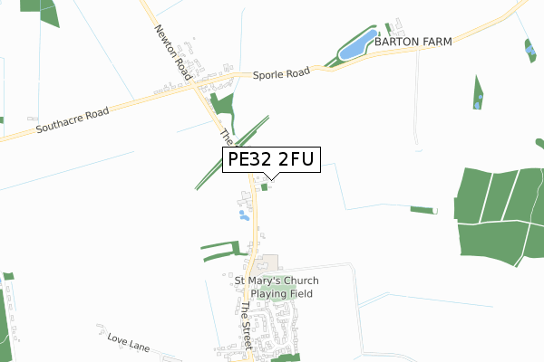
PE32 2FU is located in the Nar Valley electoral ward, within the local authority district of Breckland and the English Parliamentary constituency of South West Norfolk. The Sub Integrated Care Board (ICB) Location is NHS Norfolk and Waveney ICB - 26A and the police force is Norfolk. This postcode has been in use since August 2019.


GetTheData
Source: OS Open Zoomstack (Ordnance Survey)
Licence: Open Government Licence (requires attribution)
Attribution: Contains OS data © Crown copyright and database right 2025
Source: Open Postcode Geo
Licence: Open Government Licence (requires attribution)
Attribution: Contains OS data © Crown copyright and database right 2025; Contains Royal Mail data © Royal Mail copyright and database right 2025; Source: Office for National Statistics licensed under the Open Government Licence v.3.0
| Easting | 584964 |
| Northing | 311939 |
| Latitude | 52.673606 |
| Longitude | 0.734308 |
GetTheData
Source: Open Postcode Geo
Licence: Open Government Licence
| Country | England |
| Postcode District | PE32 |
➜ See where PE32 is on a map ➜ Where is Sporle? | |
GetTheData
Source: Land Registry Price Paid Data
Licence: Open Government Licence
| Ward | Nar Valley |
| Constituency | South West Norfolk |
GetTheData
Source: ONS Postcode Database
Licence: Open Government Licence
5, BEECH CLOSE, SPORLE, KING'S LYNN, PE32 2FU 2021 15 APR £350,000 |
3, BEECH CLOSE, SPORLE, KING'S LYNN, PE32 2FU 2021 5 FEB £340,000 |
7, BEECH CLOSE, SPORLE, KING'S LYNN, PE32 2FU 2020 30 OCT £347,500 |
11, BEECH CLOSE, SPORLE, KING'S LYNN, PE32 2FU 2020 29 OCT £388,000 |
9, BEECH CLOSE, SPORLE, KING'S LYNN, PE32 2FU 2019 18 SEP £405,000 |
GetTheData
Source: HM Land Registry Price Paid Data
Licence: Contains HM Land Registry data © Crown copyright and database right 2025. This data is licensed under the Open Government Licence v3.0.
| Bus Shelter (The Street) | Sporle | 493m |
| Bus Shelter (The Street) | Sporle | 497m |
| Priory Place (The Street) | Sporle | 607m |
| Priory Place (The Street) | Sporle | 611m |
| Bunkers Hill | Sporle | 848m |
GetTheData
Source: NaPTAN
Licence: Open Government Licence
GetTheData
Source: ONS Postcode Database
Licence: Open Government Licence


➜ Get more ratings from the Food Standards Agency
GetTheData
Source: Food Standards Agency
Licence: FSA terms & conditions
| Last Collection | |||
|---|---|---|---|
| Location | Mon-Fri | Sat | Distance |
| St Guthlac Close | 17:30 | 11:45 | 3,545m |
| Manor Way | 17:30 | 11:45 | 3,631m |
| Chantry Court Post Office | 16:30 | 10:00 | 3,979m |
GetTheData
Source: Dracos
Licence: Creative Commons Attribution-ShareAlike
The below table lists the International Territorial Level (ITL) codes (formerly Nomenclature of Territorial Units for Statistics (NUTS) codes) and Local Administrative Units (LAU) codes for PE32 2FU:
| ITL 1 Code | Name |
|---|---|
| TLH | East |
| ITL 2 Code | Name |
| TLH1 | East Anglia |
| ITL 3 Code | Name |
| TLH17 | Breckland and South Norfolk |
| LAU 1 Code | Name |
| E07000143 | Breckland |
GetTheData
Source: ONS Postcode Directory
Licence: Open Government Licence
The below table lists the Census Output Area (OA), Lower Layer Super Output Area (LSOA), and Middle Layer Super Output Area (MSOA) for PE32 2FU:
| Code | Name | |
|---|---|---|
| OA | E00134383 | |
| LSOA | E01026445 | Breckland 002C |
| MSOA | E02005504 | Breckland 002 |
GetTheData
Source: ONS Postcode Directory
Licence: Open Government Licence
| PE32 2DR | The Street | 373m |
| PE32 2DD | Dunham Road | 502m |
| PE32 2DS | The Street | 551m |
| PE32 2UG | St Marys View | 593m |
| PE32 2ES | Millfield | 603m |
| PE32 2EH | South Acre Road | 616m |
| PE32 2DT | Priory Place | 649m |
| PE32 2DB | Newton Road | 656m |
| PE32 2DU | Priory Close | 737m |
| PE32 2FH | Down Mill Drive | 814m |
GetTheData
Source: Open Postcode Geo; Land Registry Price Paid Data
Licence: Open Government Licence