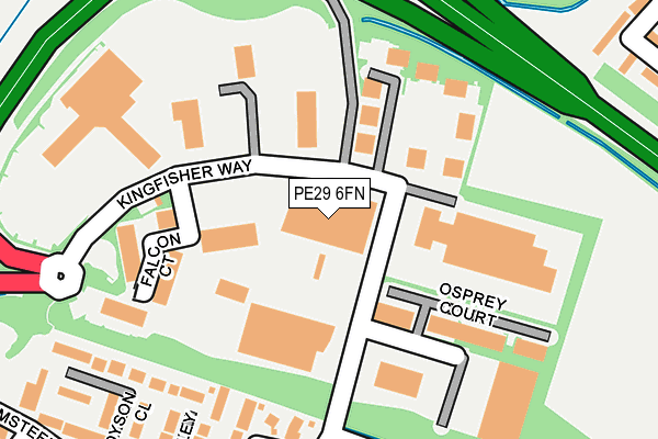
PE29 6FN lies on Kingfisher Way in Hinchingbrooke Business Park, Huntingdon. PE29 6FN is located in the Brampton electoral ward, within the local authority district of Huntingdonshire and the English Parliamentary constituency of Huntingdon. The Sub Integrated Care Board (ICB) Location is NHS Cambridgeshire and Peterborough ICB - 06H and the police force is Cambridgeshire. This postcode has been in use since June 2000.


GetTheData
Source: OS OpenMap – Local (Ordnance Survey)
Source: OS VectorMap District (Ordnance Survey)
Licence: Open Government Licence (requires attribution)
| Easting | 522202 |
| Northing | 272576 |
| Latitude | 52.337677 |
| Longitude | -0.207797 |
GetTheData
Source: Open Postcode Geo
Licence: Open Government Licence
| Street | Kingfisher Way |
| Locality | Hinchingbrooke Business Park |
| Town/City | Huntingdon |
| Country | England |
| Postcode District | PE29 |
➜ See where PE29 is on a map ➜ Where is Huntingdon? | |
GetTheData
Source: Land Registry Price Paid Data
Licence: Open Government Licence
Elevation or altitude of PE29 6FN as distance above sea level:
| Metres | Feet | |
|---|---|---|
| Elevation | 20m | 66ft |
Elevation is measured from the approximate centre of the postcode, to the nearest point on an OS contour line from OS Terrain 50, which has contour spacing of ten vertical metres.
➜ How high above sea level am I? Find the elevation of your current position using your device's GPS.
GetTheData
Source: Open Postcode Elevation
Licence: Open Government Licence
| Ward | Brampton |
| Constituency | Huntingdon |
GetTheData
Source: ONS Postcode Database
Licence: Open Government Licence
| Hinchingbrooke Business Park (Kingfisher Way) | Huntingdon | 87m |
| Hinchingbrooke Business Park (Kingfisher Way) | Huntingdon | 119m |
| Hinchingbrooke Hospital (Hinchingbrooke Park Road) | Hinchingbrooke Park | 584m |
| Snowdonia Way (Hinchingbrooke Park Road) | Hinchingbrooke Park | 873m |
| Snowdonia Way (Hinchingbrooke Park Rd) | Hinchingbrooke Park | 904m |
| Huntingdon Station | 1.5km |
GetTheData
Source: NaPTAN
Licence: Open Government Licence
| Median download speed | 80.0Mbps |
| Average download speed | 77.5Mbps |
| Maximum download speed | 80.00Mbps |
| Median upload speed | 20.0Mbps |
| Average upload speed | 19.4Mbps |
| Maximum upload speed | 20.00Mbps |
GetTheData
Source: Ofcom
Licence: Ofcom Terms of Use (requires attribution)
GetTheData
Source: ONS Postcode Database
Licence: Open Government Licence


➜ Get more ratings from the Food Standards Agency
GetTheData
Source: Food Standards Agency
Licence: FSA terms & conditions
| Last Collection | |||
|---|---|---|---|
| Location | Mon-Fri | Sat | Distance |
| Hinchingbrooke Parkway | 17:30 | 12:00 | 196m |
| Seathwaite | 17:30 | 11:30 | 521m |
| Werthen Way | 17:30 | 11:30 | 848m |
GetTheData
Source: Dracos
Licence: Creative Commons Attribution-ShareAlike
The below table lists the International Territorial Level (ITL) codes (formerly Nomenclature of Territorial Units for Statistics (NUTS) codes) and Local Administrative Units (LAU) codes for PE29 6FN:
| ITL 1 Code | Name |
|---|---|
| TLH | East |
| ITL 2 Code | Name |
| TLH1 | East Anglia |
| ITL 3 Code | Name |
| TLH12 | Cambridgeshire CC |
| LAU 1 Code | Name |
| E07000011 | Huntingdonshire |
GetTheData
Source: ONS Postcode Directory
Licence: Open Government Licence
The below table lists the Census Output Area (OA), Lower Layer Super Output Area (LSOA), and Middle Layer Super Output Area (MSOA) for PE29 6FN:
| Code | Name | |
|---|---|---|
| OA | E00173791 | |
| LSOA | E01018148 | Huntingdonshire 012B |
| MSOA | E02003764 | Huntingdonshire 012 |
GetTheData
Source: ONS Postcode Directory
Licence: Open Government Licence
| PE29 6FH | Kingfisher Way | 94m |
| PE29 6FY | Ramsay Court | 99m |
| PE29 6JB | Parkway | 198m |
| PE29 6JE | Halley Close | 228m |
| PE29 6GQ | Dyson Close | 252m |
| PE29 6JA | Parkway | 269m |
| PE29 6LB | Cromwell Drive | 291m |
| PE29 6JG | Flamsteed Drive | 299m |
| PE29 6GB | Beacon Close | 323m |
| PE29 6GA | Greendale | 326m |
GetTheData
Source: Open Postcode Geo; Land Registry Price Paid Data
Licence: Open Government Licence