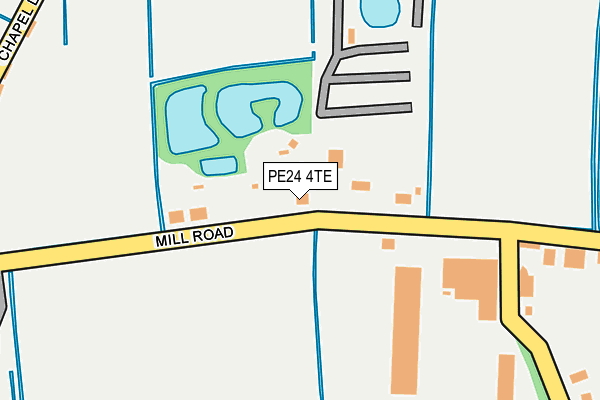
PE24 4TE lies on Mill Road in Addlethorpe, Skegness. PE24 4TE is located in the Ingoldmells electoral ward, within the local authority district of East Lindsey and the English Parliamentary constituency of Boston and Skegness. The Sub Integrated Care Board (ICB) Location is NHS Lincolnshire ICB - 71E and the police force is Lincolnshire. This postcode has been in use since January 1980.


GetTheData
Source: OS OpenMap – Local (Ordnance Survey)
Source: OS VectorMap District (Ordnance Survey)
Licence: Open Government Licence (requires attribution)
| Easting | 554892 |
| Northing | 367691 |
| Latitude | 53.183769 |
| Longitude | 0.316525 |
GetTheData
Source: Open Postcode Geo
Licence: Open Government Licence
| Street | Mill Road |
| Locality | Addlethorpe |
| Town/City | Skegness |
| Country | England |
| Postcode District | PE24 |
➜ See where PE24 is on a map ➜ Where is Addlethorpe? | |
GetTheData
Source: Land Registry Price Paid Data
Licence: Open Government Licence
Elevation or altitude of PE24 4TE as distance above sea level:
| Metres | Feet | |
|---|---|---|
| Elevation | 0m | 0ft |
Elevation is measured from the approximate centre of the postcode, to the nearest point on an OS contour line from OS Terrain 50, which has contour spacing of ten vertical metres.
➜ How high above sea level am I? Find the elevation of your current position using your device's GPS.
GetTheData
Source: Open Postcode Elevation
Licence: Open Government Licence
| Ward | Ingoldmells |
| Constituency | Boston And Skegness |
GetTheData
Source: ONS Postcode Database
Licence: Open Government Licence
| Mill Road (Chapel Lane) | Addlethorpe | 331m |
| Chapel Lane (Ingoldmells Road) | Addlethorpe | 367m |
| Hide's Lane (Ingoldmells Road) | Ashington End | 1,181m |
| Demand Responsive Area | Ashington End | 1,196m |
| Hide's Lane (Ingoldmells Road) | Ashington End | 1,211m |
| Skegness Station | 4.7km |
GetTheData
Source: NaPTAN
Licence: Open Government Licence
| Percentage of properties with Next Generation Access | 100.0% |
| Percentage of properties with Superfast Broadband | 0.0% |
| Percentage of properties with Ultrafast Broadband | 0.0% |
| Percentage of properties with Full Fibre Broadband | 0.0% |
Superfast Broadband is between 30Mbps and 300Mbps
Ultrafast Broadband is > 300Mbps
| Median download speed | 11.3Mbps |
| Average download speed | 11.6Mbps |
| Maximum download speed | 22.44Mbps |
| Median upload speed | 1.2Mbps |
| Average upload speed | 1.0Mbps |
| Maximum upload speed | 1.60Mbps |
| Percentage of properties unable to receive 2Mbps | 0.0% |
| Percentage of properties unable to receive 5Mbps | 0.0% |
| Percentage of properties unable to receive 10Mbps | 0.0% |
| Percentage of properties unable to receive 30Mbps | 100.0% |
GetTheData
Source: Ofcom
Licence: Ofcom Terms of Use (requires attribution)
GetTheData
Source: ONS Postcode Database
Licence: Open Government Licence


➜ Get more ratings from the Food Standards Agency
GetTheData
Source: Food Standards Agency
Licence: FSA terms & conditions
| Last Collection | |||
|---|---|---|---|
| Location | Mon-Fri | Sat | Distance |
| Lumley Road-lloyds Bank | 17:30 | 11:45 | 4,790m |
| South Parade | 17:30 | 11:45 | 5,293m |
GetTheData
Source: Dracos
Licence: Creative Commons Attribution-ShareAlike
| Risk of PE24 4TE flooding from rivers and sea | Low |
| ➜ PE24 4TE flood map | |
GetTheData
Source: Open Flood Risk by Postcode
Licence: Open Government Licence
The below table lists the International Territorial Level (ITL) codes (formerly Nomenclature of Territorial Units for Statistics (NUTS) codes) and Local Administrative Units (LAU) codes for PE24 4TE:
| ITL 1 Code | Name |
|---|---|
| TLF | East Midlands (England) |
| ITL 2 Code | Name |
| TLF3 | Lincolnshire |
| ITL 3 Code | Name |
| TLF30 | Lincolnshire CC |
| LAU 1 Code | Name |
| E07000137 | East Lindsey |
GetTheData
Source: ONS Postcode Directory
Licence: Open Government Licence
The below table lists the Census Output Area (OA), Lower Layer Super Output Area (LSOA), and Middle Layer Super Output Area (MSOA) for PE24 4TE:
| Code | Name | |
|---|---|---|
| OA | E00132296 | |
| LSOA | E01026069 | East Lindsey 010D |
| MSOA | E02005433 | East Lindsey 010 |
GetTheData
Source: ONS Postcode Directory
Licence: Open Government Licence
| PE24 4TD | Mill Road | 306m |
| PE24 4TB | Mill Lane | 425m |
| PE24 4TG | Chapel Lane | 1020m |
| PE25 1JH | Walls Lane | 1030m |
| PE24 4TU | 1079m | |
| PE24 4TX | 1157m | |
| PE25 1PQ | Hawthorn Way | 1283m |
| PE24 4TL | Orby Road | 1287m |
| PE24 4TR | Orby Road | 1302m |
| PE25 1QH | Lime Grove | 1350m |
GetTheData
Source: Open Postcode Geo; Land Registry Price Paid Data
Licence: Open Government Licence