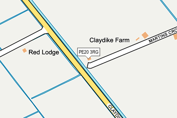
PE20 3RG is located in the Swineshead and Holland Fen electoral ward, within the local authority district of Boston and the English Parliamentary constituency of Boston and Skegness. The Sub Integrated Care Board (ICB) Location is NHS Lincolnshire ICB - 71E and the police force is Lincolnshire. This postcode has been in use since January 1980.


GetTheData
Source: OS OpenMap – Local (Ordnance Survey)
Source: OS VectorMap District (Ordnance Survey)
Licence: Open Government Licence (requires attribution)
| Easting | 524028 |
| Northing | 344785 |
| Latitude | 52.986057 |
| Longitude | -0.153891 |
GetTheData
Source: Open Postcode Geo
Licence: Open Government Licence
| Country | England |
| Postcode District | PE20 |
➜ See where PE20 is on a map | |
GetTheData
Source: Land Registry Price Paid Data
Licence: Open Government Licence
Elevation or altitude of PE20 3RG as distance above sea level:
| Metres | Feet | |
|---|---|---|
| Elevation | 0m | 0ft |
Elevation is measured from the approximate centre of the postcode, to the nearest point on an OS contour line from OS Terrain 50, which has contour spacing of ten vertical metres.
➜ How high above sea level am I? Find the elevation of your current position using your device's GPS.
GetTheData
Source: Open Postcode Elevation
Licence: Open Government Licence
| Ward | Swineshead And Holland Fen |
| Constituency | Boston And Skegness |
GetTheData
Source: ONS Postcode Database
Licence: Open Government Licence
| Ullyatt's Drove (Claydike Bank) | Amber Hill | 171m |
| Ullyatt's Drove (Claydike Bank) | Amber Hill | 175m |
| Council Houses (Claydike Bank) | Amber Hill | 656m |
| Council Houses (Claydike Bank) | Amber Hill | 658m |
| Chapel Lane (Claydike Bank) | Amber Hill | 1,257m |
| Swineshead Station | 2.9km |
| Hubberts Bridge Station | 3.1km |
GetTheData
Source: NaPTAN
Licence: Open Government Licence
| Percentage of properties with Next Generation Access | 100.0% |
| Percentage of properties with Superfast Broadband | 0.0% |
| Percentage of properties with Ultrafast Broadband | 0.0% |
| Percentage of properties with Full Fibre Broadband | 0.0% |
Superfast Broadband is between 30Mbps and 300Mbps
Ultrafast Broadband is > 300Mbps
| Percentage of properties unable to receive 2Mbps | 0.0% |
| Percentage of properties unable to receive 5Mbps | 0.0% |
| Percentage of properties unable to receive 10Mbps | 100.0% |
| Percentage of properties unable to receive 30Mbps | 100.0% |
GetTheData
Source: Ofcom
Licence: Ofcom Terms of Use (requires attribution)
GetTheData
Source: ONS Postcode Database
Licence: Open Government Licence
| Last Collection | |||
|---|---|---|---|
| Location | Mon-Fri | Sat | Distance |
| Broadsides | 16:45 | 10:00 | 1,428m |
| Swineshead Station | 17:00 | 08:00 | 2,930m |
| Toft Tunnel | 16:00 | 10:15 | 3,027m |
GetTheData
Source: Dracos
Licence: Creative Commons Attribution-ShareAlike
| Risk of PE20 3RG flooding from rivers and sea | Medium |
| ➜ PE20 3RG flood map | |
GetTheData
Source: Open Flood Risk by Postcode
Licence: Open Government Licence
The below table lists the International Territorial Level (ITL) codes (formerly Nomenclature of Territorial Units for Statistics (NUTS) codes) and Local Administrative Units (LAU) codes for PE20 3RG:
| ITL 1 Code | Name |
|---|---|
| TLF | East Midlands (England) |
| ITL 2 Code | Name |
| TLF3 | Lincolnshire |
| ITL 3 Code | Name |
| TLF30 | Lincolnshire CC |
| LAU 1 Code | Name |
| E07000136 | Boston |
GetTheData
Source: ONS Postcode Directory
Licence: Open Government Licence
The below table lists the Census Output Area (OA), Lower Layer Super Output Area (LSOA), and Middle Layer Super Output Area (MSOA) for PE20 3RG:
| Code | Name | |
|---|---|---|
| OA | E00132111 | |
| LSOA | E01026033 | Boston 006B |
| MSOA | E02005422 | Boston 006 |
GetTheData
Source: ONS Postcode Directory
Licence: Open Government Licence
| PE20 3RL | Claydyke Bank | 699m |
| PE20 3RF | Sutterton Drove | 931m |
| PE20 3RB | Claydyke Bank | 934m |
| PE20 3RJ | Chapel Lane | 1355m |
| PE20 3RA | Lineside | 1441m |
| PE20 1TP | South Forty Foot Bank | 1451m |
| PE20 3QZ | Lineside | 1574m |
| PE20 3RN | Claydyke Bank | 1660m |
| PE20 3SZ | 1825m | |
| PE20 3QY | Lineside | 2294m |
GetTheData
Source: Open Postcode Geo; Land Registry Price Paid Data
Licence: Open Government Licence