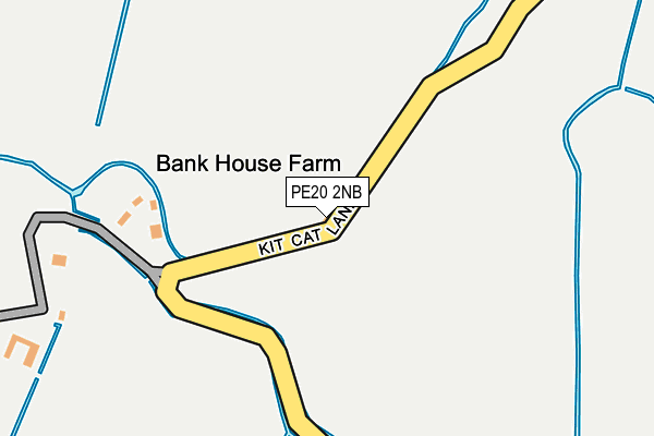
PE20 2NB is located in the Five Village electoral ward, within the local authority district of Boston and the English Parliamentary constituency of Boston and Skegness. The Sub Integrated Care Board (ICB) Location is NHS Lincolnshire ICB - 71E and the police force is Lincolnshire. This postcode has been in use since January 1980.


GetTheData
Source: OS OpenMap – Local (Ordnance Survey)
Source: OS VectorMap District (Ordnance Survey)
Licence: Open Government Licence (requires attribution)
| Easting | 526871 |
| Northing | 333430 |
| Latitude | 52.883374 |
| Longitude | -0.116002 |
GetTheData
Source: Open Postcode Geo
Licence: Open Government Licence
| Country | England |
| Postcode District | PE20 |
➜ See where PE20 is on a map | |
GetTheData
Source: Land Registry Price Paid Data
Licence: Open Government Licence
Elevation or altitude of PE20 2NB as distance above sea level:
| Metres | Feet | |
|---|---|---|
| Elevation | 0m | 0ft |
Elevation is measured from the approximate centre of the postcode, to the nearest point on an OS contour line from OS Terrain 50, which has contour spacing of ten vertical metres.
➜ How high above sea level am I? Find the elevation of your current position using your device's GPS.
GetTheData
Source: Open Postcode Elevation
Licence: Open Government Licence
| Ward | Five Village |
| Constituency | Boston And Skegness |
GetTheData
Source: ONS Postcode Database
Licence: Open Government Licence
| Burtoft Lane (Spalding Road) | Burtoft | 1,079m |
| Burtoft Lane (Spalding Road) | Burtoft | 1,081m |
| Cooks Road (Boston Road) | Gosberton Bank | 1,336m |
| Cooks Road (Boston Road) | Gosberton Bank | 1,378m |
| Willow Tree Farm (Dowdyke Road) | Sutterton Dowdyke | 1,452m |
GetTheData
Source: NaPTAN
Licence: Open Government Licence
| Percentage of properties with Next Generation Access | 100.0% |
| Percentage of properties with Superfast Broadband | 0.0% |
| Percentage of properties with Ultrafast Broadband | 0.0% |
| Percentage of properties with Full Fibre Broadband | 0.0% |
Superfast Broadband is between 30Mbps and 300Mbps
Ultrafast Broadband is > 300Mbps
| Percentage of properties unable to receive 2Mbps | 0.0% |
| Percentage of properties unable to receive 5Mbps | 66.7% |
| Percentage of properties unable to receive 10Mbps | 66.7% |
| Percentage of properties unable to receive 30Mbps | 100.0% |
GetTheData
Source: Ofcom
Licence: Ofcom Terms of Use (requires attribution)
GetTheData
Source: ONS Postcode Database
Licence: Open Government Licence
| Last Collection | |||
|---|---|---|---|
| Location | Mon-Fri | Sat | Distance |
| Waggoners Rest Public House | 16:00 | 07:45 | 2,305m |
| Moulton Marsh | 10:30 | 10:30 | 5,567m |
GetTheData
Source: Dracos
Licence: Creative Commons Attribution-ShareAlike
| Risk of PE20 2NB flooding from rivers and sea | Medium |
| ➜ PE20 2NB flood map | |
GetTheData
Source: Open Flood Risk by Postcode
Licence: Open Government Licence
The below table lists the International Territorial Level (ITL) codes (formerly Nomenclature of Territorial Units for Statistics (NUTS) codes) and Local Administrative Units (LAU) codes for PE20 2NB:
| ITL 1 Code | Name |
|---|---|
| TLF | East Midlands (England) |
| ITL 2 Code | Name |
| TLF3 | Lincolnshire |
| ITL 3 Code | Name |
| TLF30 | Lincolnshire CC |
| LAU 1 Code | Name |
| E07000136 | Boston |
GetTheData
Source: ONS Postcode Directory
Licence: Open Government Licence
The below table lists the Census Output Area (OA), Lower Layer Super Output Area (LSOA), and Middle Layer Super Output Area (MSOA) for PE20 2NB:
| Code | Name | |
|---|---|---|
| OA | E00132019 | |
| LSOA | E01026017 | Boston 007A |
| MSOA | E02005423 | Boston 007 |
GetTheData
Source: ONS Postcode Directory
Licence: Open Government Licence
| PE20 2PG | Old Spalding Road | 626m |
| PE11 4PE | Cooks Road | 902m |
| PE20 2PF | Burtoft Lane South | 1144m |
| PE20 2LB | Dowdyke Road | 1199m |
| PE11 4PD | Cook Road | 1305m |
| PE20 2LA | Broad Lane | 1344m |
| PE20 2LY | Dowdyke Road | 1427m |
| PE20 2EW | Spalding Road | 1654m |
| PE20 2LD | Waterbelly Lane | 1699m |
| PE11 4PB | Gosberton Bank | 1790m |
GetTheData
Source: Open Postcode Geo; Land Registry Price Paid Data
Licence: Open Government Licence