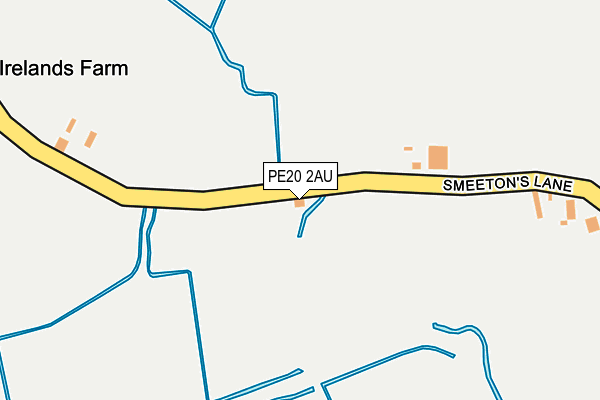
PE20 2AU lies on Smeetons Lane in Fosdyke, Boston. PE20 2AU is located in the Five Village electoral ward, within the local authority district of Boston and the English Parliamentary constituency of Boston and Skegness. The Sub Integrated Care Board (ICB) Location is NHS Lincolnshire ICB - 71E and the police force is Lincolnshire. This postcode has been in use since January 1980.


GetTheData
Source: OS OpenMap – Local (Ordnance Survey)
Source: OS VectorMap District (Ordnance Survey)
Licence: Open Government Licence (requires attribution)
| Easting | 530691 |
| Northing | 332293 |
| Latitude | 52.872246 |
| Longitude | -0.059723 |
GetTheData
Source: Open Postcode Geo
Licence: Open Government Licence
| Street | Smeetons Lane |
| Locality | Fosdyke |
| Town/City | Boston |
| Country | England |
| Postcode District | PE20 |
➜ See where PE20 is on a map | |
GetTheData
Source: Land Registry Price Paid Data
Licence: Open Government Licence
Elevation or altitude of PE20 2AU as distance above sea level:
| Metres | Feet | |
|---|---|---|
| Elevation | 0m | 0ft |
Elevation is measured from the approximate centre of the postcode, to the nearest point on an OS contour line from OS Terrain 50, which has contour spacing of ten vertical metres.
➜ How high above sea level am I? Find the elevation of your current position using your device's GPS.
GetTheData
Source: Open Postcode Elevation
Licence: Open Government Licence
| Ward | Five Village |
| Constituency | Boston And Skegness |
GetTheData
Source: ONS Postcode Database
Licence: Open Government Licence
| Wash Road (A17 Layby) | Fosdyke Bridge | 1,082m |
| Cropley Garage (A17) | Fosdyke | 1,160m |
| Demand Responsive Area | Fosdyke | 1,230m |
| Waste Green Lane (A17) | Fosdyke | 1,248m |
| Waste Green Lane (A17) | Fosdyke | 1,271m |
GetTheData
Source: NaPTAN
Licence: Open Government Licence
| Percentage of properties with Next Generation Access | 100.0% |
| Percentage of properties with Superfast Broadband | 83.3% |
| Percentage of properties with Ultrafast Broadband | 0.0% |
| Percentage of properties with Full Fibre Broadband | 0.0% |
Superfast Broadband is between 30Mbps and 300Mbps
Ultrafast Broadband is > 300Mbps
| Percentage of properties unable to receive 2Mbps | 0.0% |
| Percentage of properties unable to receive 5Mbps | 0.0% |
| Percentage of properties unable to receive 10Mbps | 0.0% |
| Percentage of properties unable to receive 30Mbps | 16.7% |
GetTheData
Source: Ofcom
Licence: Ofcom Terms of Use (requires attribution)
GetTheData
Source: ONS Postcode Database
Licence: Open Government Licence


➜ Get more ratings from the Food Standards Agency
GetTheData
Source: Food Standards Agency
Licence: FSA terms & conditions
| Last Collection | |||
|---|---|---|---|
| Location | Mon-Fri | Sat | Distance |
| Waggoners Rest Public House | 16:00 | 07:45 | 2,702m |
| Moulton Marsh | 10:30 | 10:30 | 2,724m |
| Leadenhall | 15:15 | 09:00 | 4,931m |
GetTheData
Source: Dracos
Licence: Creative Commons Attribution-ShareAlike
| Risk of PE20 2AU flooding from rivers and sea | Medium |
| ➜ PE20 2AU flood map | |
GetTheData
Source: Open Flood Risk by Postcode
Licence: Open Government Licence
The below table lists the International Territorial Level (ITL) codes (formerly Nomenclature of Territorial Units for Statistics (NUTS) codes) and Local Administrative Units (LAU) codes for PE20 2AU:
| ITL 1 Code | Name |
|---|---|
| TLF | East Midlands (England) |
| ITL 2 Code | Name |
| TLF3 | Lincolnshire |
| ITL 3 Code | Name |
| TLF30 | Lincolnshire CC |
| LAU 1 Code | Name |
| E07000136 | Boston |
GetTheData
Source: ONS Postcode Directory
Licence: Open Government Licence
The below table lists the Census Output Area (OA), Lower Layer Super Output Area (LSOA), and Middle Layer Super Output Area (MSOA) for PE20 2AU:
| Code | Name | |
|---|---|---|
| OA | E00132014 | |
| LSOA | E01026017 | Boston 007A |
| MSOA | E02005423 | Boston 007 |
GetTheData
Source: ONS Postcode Directory
Licence: Open Government Licence
| PE20 2DB | Main Road | 1009m |
| PE20 2BH | Main Road | 1111m |
| PE20 2AY | Marsh Lane | 1112m |
| PE20 2AP | Waste Green Lane | 1127m |
| PE20 2BB | Marsh Lane | 1140m |
| PE20 2DA | Snaith Avenue | 1212m |
| PE20 2BU | Old Main Road | 1250m |
| PE20 2BX | Puttock Gate | 1289m |
| PE20 2AZ | Roman Bank | 1317m |
| PE20 2DD | Coastguard Station | 1321m |
GetTheData
Source: Open Postcode Geo; Land Registry Price Paid Data
Licence: Open Government Licence