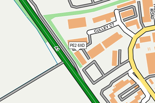
PE2 6XD lies on Culley Court in Orton Southgate, Peterborough. PE2 6XD is located in the Orton Waterville electoral ward, within the unitary authority of Peterborough and the English Parliamentary constituency of North West Cambridgeshire. The Sub Integrated Care Board (ICB) Location is NHS Cambridgeshire and Peterborough ICB - 06H and the police force is Cambridgeshire. This postcode has been in use since February 2008.


GetTheData
Source: OS OpenMap – Local (Ordnance Survey)
Source: OS VectorMap District (Ordnance Survey)
Licence: Open Government Licence (requires attribution)
| Easting | 513840 |
| Northing | 294795 |
| Latitude | 52.539142 |
| Longitude | -0.322911 |
GetTheData
Source: Open Postcode Geo
Licence: Open Government Licence
| Street | Culley Court |
| Locality | Orton Southgate |
| Town/City | Peterborough |
| Country | England |
| Postcode District | PE2 |
➜ See where PE2 is on a map ➜ Where is Peterborough? | |
GetTheData
Source: Land Registry Price Paid Data
Licence: Open Government Licence
Elevation or altitude of PE2 6XD as distance above sea level:
| Metres | Feet | |
|---|---|---|
| Elevation | 20m | 66ft |
Elevation is measured from the approximate centre of the postcode, to the nearest point on an OS contour line from OS Terrain 50, which has contour spacing of ten vertical metres.
➜ How high above sea level am I? Find the elevation of your current position using your device's GPS.
GetTheData
Source: Open Postcode Elevation
Licence: Open Government Licence
| Ward | Orton Waterville |
| Constituency | North West Cambridgeshire |
GetTheData
Source: ONS Postcode Database
Licence: Open Government Licence
| Cappuco Pumps (Bakewell Road) | Orton Southgate | 169m |
| Southgate Park (Bakewell Road) | Orton Southgate | 463m |
| Finemere Road (Southgate Way) | Orton Southgate | 549m |
| Rnib Headquarters (Bakewell Road) | Orton Southgate | 572m |
| Bakewell Road (Orton Southgate) | Orton Southgate | 697m |
| Peterborough Station | 6.4km |
GetTheData
Source: NaPTAN
Licence: Open Government Licence
GetTheData
Source: ONS Postcode Database
Licence: Open Government Licence

➜ Get more ratings from the Food Standards Agency
GetTheData
Source: Food Standards Agency
Licence: FSA terms & conditions
| Last Collection | |||
|---|---|---|---|
| Location | Mon-Fri | Sat | Distance |
| Newcombe Way | 946m | ||
| Newcombe Way | 18:15 | 12:45 | 946m |
| Dunblane Drive | 18:00 | 13:00 | 1,103m |
GetTheData
Source: Dracos
Licence: Creative Commons Attribution-ShareAlike
The below table lists the International Territorial Level (ITL) codes (formerly Nomenclature of Territorial Units for Statistics (NUTS) codes) and Local Administrative Units (LAU) codes for PE2 6XD:
| ITL 1 Code | Name |
|---|---|
| TLH | East |
| ITL 2 Code | Name |
| TLH1 | East Anglia |
| ITL 3 Code | Name |
| TLH11 | Peterborough |
| LAU 1 Code | Name |
| E06000031 | Peterborough |
GetTheData
Source: ONS Postcode Directory
Licence: Open Government Licence
The below table lists the Census Output Area (OA), Lower Layer Super Output Area (LSOA), and Middle Layer Super Output Area (MSOA) for PE2 6XD:
| Code | Name | |
|---|---|---|
| OA | E00079119 | |
| LSOA | E01015644 | Peterborough 018B |
| MSOA | E02003254 | Peterborough 018 |
GetTheData
Source: ONS Postcode Directory
Licence: Open Government Licence
| PE2 6XJ | B G L Park | 129m |
| PE2 6WA | Culley Court | 174m |
| PE2 6BW | Routeco Business Park | 295m |
| PE2 6XS | Accent Park | 345m |
| PE2 6XU | Bakewell Road | 424m |
| PE7 3UH | Great North Road | 465m |
| PE2 6UP | Manasty Road | 765m |
| PE2 6YG | Southgate Way | 789m |
| PE7 3UJ | Great North Road | 798m |
| PE2 6HB | Arena Drive | 991m |
GetTheData
Source: Open Postcode Geo; Land Registry Price Paid Data
Licence: Open Government Licence