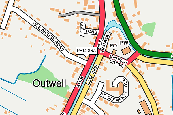
PE14 8RA is located in the Emneth & Outwell electoral ward, within the local authority district of King's Lynn and West Norfolk and the English Parliamentary constituency of South West Norfolk. The Sub Integrated Care Board (ICB) Location is NHS Norfolk and Waveney ICB - 26A and the police force is Norfolk. This postcode has been in use since January 1980.


GetTheData
Source: OS OpenMap – Local (Ordnance Survey)
Source: OS VectorMap District (Ordnance Survey)
Licence: Open Government Licence (requires attribution)
| Easting | 551238 |
| Northing | 303642 |
| Latitude | 52.609506 |
| Longitude | 0.232121 |
GetTheData
Source: Open Postcode Geo
Licence: Open Government Licence
| Country | England |
| Postcode District | PE14 |
➜ See where PE14 is on a map ➜ Where is Outwell? | |
GetTheData
Source: Land Registry Price Paid Data
Licence: Open Government Licence
Elevation or altitude of PE14 8RA as distance above sea level:
| Metres | Feet | |
|---|---|---|
| Elevation | 0m | 0ft |
Elevation is measured from the approximate centre of the postcode, to the nearest point on an OS contour line from OS Terrain 50, which has contour spacing of ten vertical metres.
➜ How high above sea level am I? Find the elevation of your current position using your device's GPS.
GetTheData
Source: Open Postcode Elevation
Licence: Open Government Licence
| Ward | Emneth & Outwell |
| Constituency | South West Norfolk |
GetTheData
Source: ONS Postcode Database
Licence: Open Government Licence
| Isle Bridge Road (Rectory Road) | Outwell | 14m |
| Isle Bridge Road (Rectory Road) | Outwell | 22m |
| Isle Road | Outwell | 210m |
| Pius Drove (Town Street) | Outwell | 685m |
| Pius Drove (Town Street) | Outwell | 709m |
GetTheData
Source: NaPTAN
Licence: Open Government Licence
GetTheData
Source: ONS Postcode Database
Licence: Open Government Licence


➜ Get more ratings from the Food Standards Agency
GetTheData
Source: Food Standards Agency
Licence: FSA terms & conditions
| Last Collection | |||
|---|---|---|---|
| Location | Mon-Fri | Sat | Distance |
| Outwell Post Office | 16:15 | 09:30 | 91m |
| Lister Road Upwell | 16:00 | 08:00 | 1,061m |
| Small Lode Upwell | 09:00 | 07:15 | 1,293m |
GetTheData
Source: Dracos
Licence: Creative Commons Attribution-ShareAlike
| Risk of PE14 8RA flooding from rivers and sea | Medium |
| ➜ PE14 8RA flood map | |
GetTheData
Source: Open Flood Risk by Postcode
Licence: Open Government Licence
The below table lists the International Territorial Level (ITL) codes (formerly Nomenclature of Territorial Units for Statistics (NUTS) codes) and Local Administrative Units (LAU) codes for PE14 8RA:
| ITL 1 Code | Name |
|---|---|
| TLH | East |
| ITL 2 Code | Name |
| TLH1 | East Anglia |
| ITL 3 Code | Name |
| TLH16 | North and West Norfolk |
| LAU 1 Code | Name |
| E07000146 | King's Lynn and West Norfolk |
GetTheData
Source: ONS Postcode Directory
Licence: Open Government Licence
The below table lists the Census Output Area (OA), Lower Layer Super Output Area (LSOA), and Middle Layer Super Output Area (MSOA) for PE14 8RA:
| Code | Name | |
|---|---|---|
| OA | E00135491 | |
| LSOA | E01026659 | King's Lynn and West Norfolk 016A |
| MSOA | E02005566 | King's Lynn and West Norfolk 016 |
GetTheData
Source: ONS Postcode Directory
Licence: Open Government Licence
| PE14 8RE | Lowside | 81m |
| PE14 8PZ | The Tramway | 95m |
| PE14 8RQ | Church Terrace | 98m |
| PE14 8TA | Suttons Close | 107m |
| PE14 8RG | The Mews | 137m |
| PE14 8TB | Robbs Chase | 207m |
| PE14 8RF | Lowside | 215m |
| PE14 8RD | Rectory Road | 217m |
| PE14 8RB | Isle Bridge Road | 222m |
| PE14 8PA | Wisbech Road | 223m |
GetTheData
Source: Open Postcode Geo; Land Registry Price Paid Data
Licence: Open Government Licence