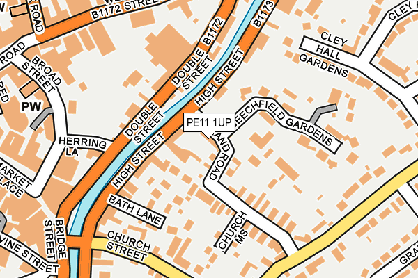
PE11 1UP lies on Holland Road in Spalding. PE11 1UP is located in the Spalding St Mary's electoral ward, within the local authority district of South Holland and the English Parliamentary constituency of South Holland and The Deepings. The Sub Integrated Care Board (ICB) Location is NHS Lincolnshire ICB - 71E and the police force is Lincolnshire. This postcode has been in use since April 2016.


GetTheData
Source: OS OpenMap – Local (Ordnance Survey)
Source: OS VectorMap District (Ordnance Survey)
Licence: Open Government Licence (requires attribution)
| Easting | 525059 |
| Northing | 322689 |
| Latitude | 52.787314 |
| Longitude | -0.147016 |
GetTheData
Source: Open Postcode Geo
Licence: Open Government Licence
| Street | Holland Road |
| Town/City | Spalding |
| Country | England |
| Postcode District | PE11 |
➜ See where PE11 is on a map ➜ Where is Spalding? | |
GetTheData
Source: Land Registry Price Paid Data
Licence: Open Government Licence
Elevation or altitude of PE11 1UP as distance above sea level:
| Metres | Feet | |
|---|---|---|
| Elevation | 10m | 33ft |
Elevation is measured from the approximate centre of the postcode, to the nearest point on an OS contour line from OS Terrain 50, which has contour spacing of ten vertical metres.
➜ How high above sea level am I? Find the elevation of your current position using your device's GPS.
GetTheData
Source: Open Postcode Elevation
Licence: Open Government Licence
| Ward | Spalding St Mary's |
| Constituency | South Holland And The Deepings |
GetTheData
Source: ONS Postcode Database
Licence: Open Government Licence
| Holland Road (High Street) | Spalding | 52m |
| Grange Drive (Halmer Gate) | Spalding | 225m |
| Grange Drive (Halmer Gate) | Spalding | 232m |
| Oak Court (Stonegate) | Spalding | 302m |
| Broad Street (New Road) | Spalding | 314m |
| Spalding Station | 0.7km |
GetTheData
Source: NaPTAN
Licence: Open Government Licence
| Percentage of properties with Next Generation Access | 100.0% |
| Percentage of properties with Superfast Broadband | 100.0% |
| Percentage of properties with Ultrafast Broadband | 0.0% |
| Percentage of properties with Full Fibre Broadband | 0.0% |
Superfast Broadband is between 30Mbps and 300Mbps
Ultrafast Broadband is > 300Mbps
| Median download speed | 58.1Mbps |
| Average download speed | 51.6Mbps |
| Maximum download speed | 79.70Mbps |
| Median upload speed | 14.7Mbps |
| Average upload speed | 11.9Mbps |
| Maximum upload speed | 20.00Mbps |
| Percentage of properties unable to receive 2Mbps | 0.0% |
| Percentage of properties unable to receive 5Mbps | 0.0% |
| Percentage of properties unable to receive 10Mbps | 0.0% |
| Percentage of properties unable to receive 30Mbps | 0.0% |
GetTheData
Source: Ofcom
Licence: Ofcom Terms of Use (requires attribution)
GetTheData
Source: ONS Postcode Database
Licence: Open Government Licence


➜ Get more ratings from the Food Standards Agency
GetTheData
Source: Food Standards Agency
Licence: FSA terms & conditions
| Last Collection | |||
|---|---|---|---|
| Location | Mon-Fri | Sat | Distance |
| Westlode Street | 17:45 | 12:00 | 371m |
| Horseshoe Road Bridge | 16:00 | 11:00 | 901m |
| Springfields | 17:40 | 12:00 | 1,815m |
GetTheData
Source: Dracos
Licence: Creative Commons Attribution-ShareAlike
| Risk of PE11 1UP flooding from rivers and sea | Medium |
| ➜ PE11 1UP flood map | |
GetTheData
Source: Open Flood Risk by Postcode
Licence: Open Government Licence
The below table lists the International Territorial Level (ITL) codes (formerly Nomenclature of Territorial Units for Statistics (NUTS) codes) and Local Administrative Units (LAU) codes for PE11 1UP:
| ITL 1 Code | Name |
|---|---|
| TLF | East Midlands (England) |
| ITL 2 Code | Name |
| TLF3 | Lincolnshire |
| ITL 3 Code | Name |
| TLF30 | Lincolnshire CC |
| LAU 1 Code | Name |
| E07000140 | South Holland |
GetTheData
Source: ONS Postcode Directory
Licence: Open Government Licence
The below table lists the Census Output Area (OA), Lower Layer Super Output Area (LSOA), and Middle Layer Super Output Area (MSOA) for PE11 1UP:
| Code | Name | |
|---|---|---|
| OA | E00133440 | |
| LSOA | E01026272 | South Holland 007E |
| MSOA | E02005471 | South Holland 007 |
GetTheData
Source: ONS Postcode Directory
Licence: Open Government Licence
| PE11 1UG | High Street | 71m |
| PE11 1TW | High Street | 85m |
| PE11 1UD | High Street | 89m |
| PE11 1XW | High Street | 104m |
| PE11 1UL | Holland Road | 109m |
| PE11 1XP | Bath Lane | 110m |
| PE11 2AA | Double Street | 120m |
| PE11 1UN | Beechfield Gardens | 136m |
| PE11 2AB | Double Street | 157m |
| PE11 1JP | Church Mews | 159m |
GetTheData
Source: Open Postcode Geo; Land Registry Price Paid Data
Licence: Open Government Licence