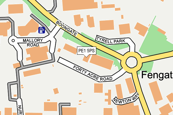
PE1 5PS lies on Forty Acre Road in Peterborough. PE1 5PS is located in the East electoral ward, within the unitary authority of Peterborough and the English Parliamentary constituency of Peterborough. The Sub Integrated Care Board (ICB) Location is NHS Cambridgeshire and Peterborough ICB - 06H and the police force is Cambridgeshire. This postcode has been in use since January 1980.


GetTheData
Source: OS OpenMap – Local (Ordnance Survey)
Source: OS VectorMap District (Ordnance Survey)
Licence: Open Government Licence (requires attribution)
| Easting | 520814 |
| Northing | 298772 |
| Latitude | 52.573359 |
| Longitude | -0.218705 |
GetTheData
Source: Open Postcode Geo
Licence: Open Government Licence
| Street | Forty Acre Road |
| Town/City | Peterborough |
| Country | England |
| Postcode District | PE1 |
➜ See where PE1 is on a map ➜ Where is Peterborough? | |
GetTheData
Source: Land Registry Price Paid Data
Licence: Open Government Licence
Elevation or altitude of PE1 5PS as distance above sea level:
| Metres | Feet | |
|---|---|---|
| Elevation | 10m | 33ft |
Elevation is measured from the approximate centre of the postcode, to the nearest point on an OS contour line from OS Terrain 50, which has contour spacing of ten vertical metres.
➜ How high above sea level am I? Find the elevation of your current position using your device's GPS.
GetTheData
Source: Open Postcode Elevation
Licence: Open Government Licence
| Ward | East |
| Constituency | Peterborough |
GetTheData
Source: ONS Postcode Database
Licence: Open Government Licence
| Second Drove (Fengate) | Fengate | 257m |
| Second Drove (Fengate) | Fengate | 295m |
| First Drove (Fengate) | Fengate | 339m |
| First Drove (Fengate) | Fengate | 356m |
| Showcase Cinema (Mallory Road) | Eastern Industry | 369m |
| Peterborough Station | 2.1km |
GetTheData
Source: NaPTAN
Licence: Open Government Licence
GetTheData
Source: ONS Postcode Database
Licence: Open Government Licence


➜ Get more ratings from the Food Standards Agency
GetTheData
Source: Food Standards Agency
Licence: FSA terms & conditions
| Last Collection | |||
|---|---|---|---|
| Location | Mon-Fri | Sat | Distance |
| Second Drove | 17:45 | 12:15 | 293m |
| Vicarage Farm Road | 494m | ||
| Vicarage Farm Road | 18:15 | 12:15 | 499m |
GetTheData
Source: Dracos
Licence: Creative Commons Attribution-ShareAlike
The below table lists the International Territorial Level (ITL) codes (formerly Nomenclature of Territorial Units for Statistics (NUTS) codes) and Local Administrative Units (LAU) codes for PE1 5PS:
| ITL 1 Code | Name |
|---|---|
| TLH | East |
| ITL 2 Code | Name |
| TLH1 | East Anglia |
| ITL 3 Code | Name |
| TLH11 | Peterborough |
| LAU 1 Code | Name |
| E06000031 | Peterborough |
GetTheData
Source: ONS Postcode Directory
Licence: Open Government Licence
The below table lists the Census Output Area (OA), Lower Layer Super Output Area (LSOA), and Middle Layer Super Output Area (MSOA) for PE1 5PS:
| Code | Name | |
|---|---|---|
| OA | E00078965 | |
| LSOA | E01015611 | Peterborough 013B |
| MSOA | E02003249 | Peterborough 013 |
GetTheData
Source: ONS Postcode Directory
Licence: Open Government Licence
| PE1 5PT | Tyrrell Park | 124m |
| PE1 5AU | Mallory Road | 225m |
| PE1 5BH | Fengate | 294m |
| PE1 5XB | Fengate | 393m |
| PE1 5BB | Fengate | 430m |
| PE1 5BA | Fengate | 454m |
| PE1 5XL | Padholme Road East | 462m |
| PE1 5XA | Second Drove | 477m |
| PE1 5BJ | First Drove | 553m |
| PE1 5GY | Monksfield Mews | 566m |
GetTheData
Source: Open Postcode Geo; Land Registry Price Paid Data
Licence: Open Government Licence