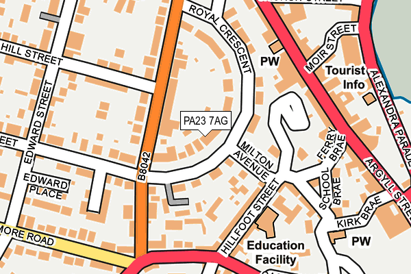
PA23 7AG is located in the Dunoon electoral ward, within the council area of Argyll and Bute and the Scottish Parliamentary constituency of Argyll and Bute. The Community Health Partnership is Argyll & Bute Community Health Partnership and the police force is Scotland. This postcode has been in use since January 1980.


GetTheData
Source: OS OpenMap – Local (Ordnance Survey)
Source: OS VectorMap District (Ordnance Survey)
Licence: Open Government Licence (requires attribution)
| Easting | 217241 |
| Northing | 676690 |
| Latitude | 55.948378 |
| Longitude | -4.928386 |
GetTheData
Source: Open Postcode Geo
Licence: Open Government Licence
| Country | Scotland |
| Postcode District | PA23 |
➜ See where PA23 is on a map ➜ Where is Dunoon? | |
GetTheData
Source: Land Registry Price Paid Data
Licence: Open Government Licence
| Ward | Dunoon |
| Constituency | Argyll And Bute |
GetTheData
Source: ONS Postcode Database
Licence: Open Government Licence
| Dunoon Primary School (Hillfoot Street) | Dunoon | 126m |
| Auchamore Road | Dunoon | 166m |
| Moir Street (Argyll Street) | Dunoon | 168m |
| Auchamore Road | Dunoon | 177m |
| Roberts Terrace (Tom-a-mhoid Road) | Dunoon | 221m |
| Inverkip Station | 5.9km |
GetTheData
Source: NaPTAN
Licence: Open Government Licence
| Percentage of properties with Next Generation Access | 100.0% |
| Percentage of properties with Superfast Broadband | 100.0% |
| Percentage of properties with Ultrafast Broadband | 0.0% |
| Percentage of properties with Full Fibre Broadband | 0.0% |
Superfast Broadband is between 30Mbps and 300Mbps
Ultrafast Broadband is > 300Mbps
| Median download speed | 32.4Mbps |
| Average download speed | 34.4Mbps |
| Maximum download speed | 53.02Mbps |
| Median upload speed | 3.9Mbps |
| Average upload speed | 3.7Mbps |
| Maximum upload speed | 6.79Mbps |
| Percentage of properties unable to receive 2Mbps | 0.0% |
| Percentage of properties unable to receive 5Mbps | 0.0% |
| Percentage of properties unable to receive 10Mbps | 0.0% |
| Percentage of properties unable to receive 30Mbps | 0.0% |
GetTheData
Source: Ofcom
Licence: Ofcom Terms of Use (requires attribution)
Estimated total energy consumption in PA23 7AG by fuel type, 2015.
| Consumption (kWh) | 131,157 |
|---|---|
| Meter count | 6 |
| Mean (kWh/meter) | 21,859 |
| Median (kWh/meter) | 20,388 |
GetTheData
Source: Postcode level gas estimates: 2015 (experimental)
Source: Postcode level electricity estimates: 2015 (experimental)
Licence: Open Government Licence
GetTheData
Source: ONS Postcode Database
Licence: Open Government Licence


➜ Get more ratings from the Food Standards Agency
GetTheData
Source: Food Standards Agency
Licence: FSA terms & conditions
| Last Collection | |||
|---|---|---|---|
| Location | Mon-Fri | Sat | Distance |
| Victoria Road | 16:00 | 12:00 | 123m |
| Post Office | 16:00 | 12:00 | 132m |
| Moir Street | 16:00 | 12:00 | 179m |
GetTheData
Source: Dracos
Licence: Creative Commons Attribution-ShareAlike
The below table lists the International Territorial Level (ITL) codes (formerly Nomenclature of Territorial Units for Statistics (NUTS) codes) and Local Administrative Units (LAU) codes for PA23 7AG:
| ITL 1 Code | Name |
|---|---|
| TLM | Scotland |
| ITL 2 Code | Name |
| TLM6 | Highlands and Islands |
| ITL 3 Code | Name |
| TLM63 | Lochaber, Skye and Lochalsh, Arran and Cumbrae, and Argyll and Bute |
| LAU 1 Code | Name |
| S30000036 | Argyll and Bute Mainland |
GetTheData
Source: ONS Postcode Directory
Licence: Open Government Licence
The below table lists the Census Output Area (OA), Lower Layer Super Output Area (LSOA), and Middle Layer Super Output Area (MSOA) for PA23 7AG:
| Code | Name | |
|---|---|---|
| OA | S00094276 | |
| LSOA | S01007370 | Dunoon - 05 |
| MSOA | S02001386 | Dunoon |
GetTheData
Source: ONS Postcode Directory
Licence: Open Government Licence