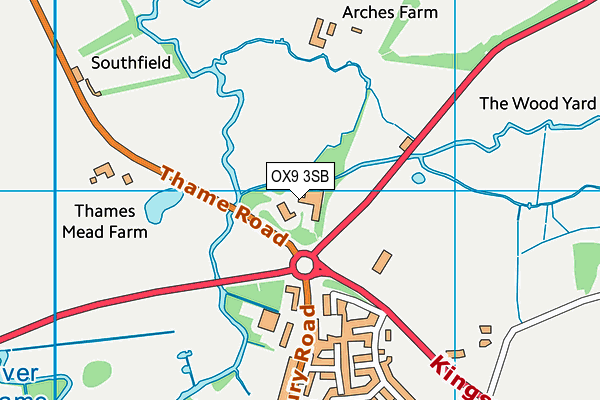
OX9 3SB lies on Long Crendon Road in Thame. OX9 3SB is located in the Thame electoral ward, within the local authority district of South Oxfordshire and the English Parliamentary constituency of Henley. The Sub Integrated Care Board (ICB) Location is NHS Buckinghamshire, Oxfordshire and Berkshire West ICB - 10Q and the police force is Thames Valley. This postcode has been in use since December 1995.


GetTheData
Source: OS OpenMap – Local (Ordnance Survey)
Source: OS VectorMap District (Ordnance Survey)
Licence: Open Government Licence (requires attribution)
| Easting | 470581 |
| Northing | 206954 |
| Latitude | 51.756842 |
| Longitude | -0.978808 |
GetTheData
Source: Open Postcode Geo
Licence: Open Government Licence
| Street | Long Crendon Road |
| Town/City | Thame |
| Country | England |
| Postcode District | OX9 |
➜ See where OX9 is on a map ➜ Where is Thame? | |
GetTheData
Source: Land Registry Price Paid Data
Licence: Open Government Licence
Elevation or altitude of OX9 3SB as distance above sea level:
| Metres | Feet | |
|---|---|---|
| Elevation | 70m | 230ft |
Elevation is measured from the approximate centre of the postcode, to the nearest point on an OS contour line from OS Terrain 50, which has contour spacing of ten vertical metres.
➜ How high above sea level am I? Find the elevation of your current position using your device's GPS.
GetTheData
Source: Open Postcode Elevation
Licence: Open Government Licence
| Ward | Thame |
| Constituency | Henley |
GetTheData
Source: ONS Postcode Database
Licence: Open Government Licence
| Queens Close (Aylesbury Road) | Thame | 372m |
| Queens Close (Aylesbury Road) | Thame | 387m |
| Southfield (Thame Road) | Long Crendon | 630m |
| Southfield (Thame Road) | Long Crendon | 634m |
| Cricket Ground (Aylesbury Road) | Thame | 742m |
| Haddenham & Thame Parkway Station | 3km |
GetTheData
Source: NaPTAN
Licence: Open Government Licence
GetTheData
Source: ONS Postcode Database
Licence: Open Government Licence


➜ Get more ratings from the Food Standards Agency
GetTheData
Source: Food Standards Agency
Licence: FSA terms & conditions
| Last Collection | |||
|---|---|---|---|
| Location | Mon-Fri | Sat | Distance |
| Queens Close | 16:45 | 08:30 | 393m |
| Greenway | 16:45 | 08:30 | 694m |
| Roundhead Drive | 16:00 | 08:45 | 713m |
GetTheData
Source: Dracos
Licence: Creative Commons Attribution-ShareAlike
| Risk of OX9 3SB flooding from rivers and sea | Low |
| ➜ OX9 3SB flood map | |
GetTheData
Source: Open Flood Risk by Postcode
Licence: Open Government Licence
The below table lists the International Territorial Level (ITL) codes (formerly Nomenclature of Territorial Units for Statistics (NUTS) codes) and Local Administrative Units (LAU) codes for OX9 3SB:
| ITL 1 Code | Name |
|---|---|
| TLJ | South East (England) |
| ITL 2 Code | Name |
| TLJ1 | Berkshire, Buckinghamshire and Oxfordshire |
| ITL 3 Code | Name |
| TLJ14 | Oxfordshire CC |
| LAU 1 Code | Name |
| E07000179 | South Oxfordshire |
GetTheData
Source: ONS Postcode Directory
Licence: Open Government Licence
The below table lists the Census Output Area (OA), Lower Layer Super Output Area (LSOA), and Middle Layer Super Output Area (MSOA) for OX9 3SB:
| Code | Name | |
|---|---|---|
| OA | E00146011 | |
| LSOA | E01028669 | South Oxfordshire 001D |
| MSOA | E02005958 | South Oxfordshire 001 |
GetTheData
Source: ONS Postcode Directory
Licence: Open Government Licence
| OX9 3TZ | Edgehill | 288m |
| OX9 3AY | Aylesbury Road | 293m |
| OX9 3DF | Fleetwood Way | 329m |
| OX9 3DQ | Roundhead Drive | 394m |
| OX9 3AZ | Queens Close | 401m |
| OX9 3DW | Skippon Way | 421m |
| OX9 3DG | Roundhead Drive | 429m |
| OX9 3AU | Aylesbury Road | 463m |
| OX9 3DT | Lambert Walk | 513m |
| OX9 3DL | Roundhead Drive | 546m |
GetTheData
Source: Open Postcode Geo; Land Registry Price Paid Data
Licence: Open Government Licence