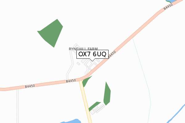
OX7 6UQ is located in the Chadlington and Churchill electoral ward, within the local authority district of West Oxfordshire and the English Parliamentary constituency of Witney. The Sub Integrated Care Board (ICB) Location is NHS Buckinghamshire, Oxfordshire and Berkshire West ICB - 10Q and the police force is Thames Valley. This postcode has been in use since April 2020.


GetTheData
Source: OS Open Zoomstack (Ordnance Survey)
Licence: Open Government Licence (requires attribution)
Attribution: Contains OS data © Crown copyright and database right 2025
Source: Open Postcode Geo
Licence: Open Government Licence (requires attribution)
Attribution: Contains OS data © Crown copyright and database right 2025; Contains Royal Mail data © Royal Mail copyright and database right 2025; Source: Office for National Statistics licensed under the Open Government Licence v.3.0
| Easting | 427034 |
| Northing | 222758 |
| Latitude | 51.902721 |
| Longitude | -1.608464 |
GetTheData
Source: Open Postcode Geo
Licence: Open Government Licence
| Country | England |
| Postcode District | OX7 |
➜ See where OX7 is on a map | |
GetTheData
Source: Land Registry Price Paid Data
Licence: Open Government Licence
| Ward | Chadlington And Churchill |
| Constituency | Witney |
GetTheData
Source: ONS Postcode Database
Licence: Open Government Licence
| Railway Station (Forecourt) | Kingham | 1,393m |
| Railway Station (Station Road) | Kingham | 1,430m |
| Railway Station (Station Road) | Kingham | 1,431m |
| New Road (Station Road) | Kingham | 1,437m |
| New Road (Station Road) | Kingham | 1,446m |
| Kingham Station | 1.4km |
| Shipton Station | 4.3km |
| Ascott-under-Wychwood Station | 5km |
GetTheData
Source: NaPTAN
Licence: Open Government Licence
GetTheData
Source: ONS Postcode Database
Licence: Open Government Licence


➜ Get more ratings from the Food Standards Agency
GetTheData
Source: Food Standards Agency
Licence: FSA terms & conditions
| Last Collection | |||
|---|---|---|---|
| Location | Mon-Fri | Sat | Distance |
| Bledington Mill | 16:00 | 09:20 | 1,965m |
| Foscot | 16:00 | 09:15 | 2,255m |
| Church Lane, Bledington | 16:00 | 09:15 | 2,348m |
GetTheData
Source: Dracos
Licence: Creative Commons Attribution-ShareAlike
The below table lists the International Territorial Level (ITL) codes (formerly Nomenclature of Territorial Units for Statistics (NUTS) codes) and Local Administrative Units (LAU) codes for OX7 6UQ:
| ITL 1 Code | Name |
|---|---|
| TLJ | South East (England) |
| ITL 2 Code | Name |
| TLJ1 | Berkshire, Buckinghamshire and Oxfordshire |
| ITL 3 Code | Name |
| TLJ14 | Oxfordshire CC |
| LAU 1 Code | Name |
| E07000181 | West Oxfordshire |
GetTheData
Source: ONS Postcode Directory
Licence: Open Government Licence
The below table lists the Census Output Area (OA), Lower Layer Super Output Area (LSOA), and Middle Layer Super Output Area (MSOA) for OX7 6UQ:
| Code | Name | |
|---|---|---|
| OA | E00146571 | |
| LSOA | E01028776 | West Oxfordshire 003B |
| MSOA | E02005995 | West Oxfordshire 003 |
GetTheData
Source: ONS Postcode Directory
Licence: Open Government Licence
| OX7 6UL | Rynehill Farm Cottage | 22m |
| OX7 6UN | Lyneham Road | 535m |
| OX7 6UJ | 821m | |
| OX7 6PT | Sarsden Lodge Cottages | 998m |
| OX7 6UW | Langston Villas | 1189m |
| OX7 6UP | Station Road | 1244m |
| OX7 6UH | Station Road | 1346m |
| OX7 6YU | Fowlers Road | 1425m |
| OX7 6PS | 1448m | |
| OX7 6YR | Field Road | 1468m |
GetTheData
Source: Open Postcode Geo; Land Registry Price Paid Data
Licence: Open Government Licence