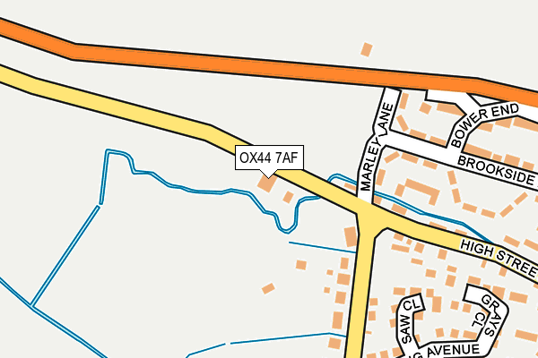
OX44 7AF is located in the Chalgrove electoral ward, within the local authority district of South Oxfordshire and the English Parliamentary constituency of Henley. The Sub Integrated Care Board (ICB) Location is NHS Buckinghamshire, Oxfordshire and Berkshire West ICB - 10Q and the police force is Thames Valley. This postcode has been in use since April 2003.


GetTheData
Source: OS OpenMap – Local (Ordnance Survey)
Source: OS VectorMap District (Ordnance Survey)
Licence: Open Government Licence (requires attribution)
| Easting | 463041 |
| Northing | 197285 |
| Latitude | 51.670810 |
| Longitude | -1.089799 |
GetTheData
Source: Open Postcode Geo
Licence: Open Government Licence
| Country | England |
| Postcode District | OX44 |
➜ See where OX44 is on a map ➜ Where is Chalgrove? | |
GetTheData
Source: Land Registry Price Paid Data
Licence: Open Government Licence
Elevation or altitude of OX44 7AF as distance above sea level:
| Metres | Feet | |
|---|---|---|
| Elevation | 70m | 230ft |
Elevation is measured from the approximate centre of the postcode, to the nearest point on an OS contour line from OS Terrain 50, which has contour spacing of ten vertical metres.
➜ How high above sea level am I? Find the elevation of your current position using your device's GPS.
GetTheData
Source: Open Postcode Elevation
Licence: Open Government Licence
| Ward | Chalgrove |
| Constituency | Henley |
GetTheData
Source: ONS Postcode Database
Licence: Open Government Licence
| The Lamb Ph (High Street) | Chalgrove | 121m |
| The Lamb Ph (High Street) | Chalgrove | 148m |
| Quartermain Road (High Street) | Chalgrove | 444m |
| Quartermain Road (High Street) | Chalgrove | 446m |
| The Red Lion Ph (High Street) | Chalgrove | 725m |
GetTheData
Source: NaPTAN
Licence: Open Government Licence
GetTheData
Source: ONS Postcode Database
Licence: Open Government Licence


➜ Get more ratings from the Food Standards Agency
GetTheData
Source: Food Standards Agency
Licence: FSA terms & conditions
| Last Collection | |||
|---|---|---|---|
| Location | Mon-Fri | Sat | Distance |
| Brookside | 17:30 | 11:25 | 114m |
| Chalgrove Post Office | 17:30 | 11:20 | 675m |
| Monumont Road | 17:30 | 09:15 | 1,328m |
GetTheData
Source: Dracos
Licence: Creative Commons Attribution-ShareAlike
| Risk of OX44 7AF flooding from rivers and sea | Medium |
| ➜ OX44 7AF flood map | |
GetTheData
Source: Open Flood Risk by Postcode
Licence: Open Government Licence
The below table lists the International Territorial Level (ITL) codes (formerly Nomenclature of Territorial Units for Statistics (NUTS) codes) and Local Administrative Units (LAU) codes for OX44 7AF:
| ITL 1 Code | Name |
|---|---|
| TLJ | South East (England) |
| ITL 2 Code | Name |
| TLJ1 | Berkshire, Buckinghamshire and Oxfordshire |
| ITL 3 Code | Name |
| TLJ14 | Oxfordshire CC |
| LAU 1 Code | Name |
| E07000179 | South Oxfordshire |
GetTheData
Source: ONS Postcode Directory
Licence: Open Government Licence
The below table lists the Census Output Area (OA), Lower Layer Super Output Area (LSOA), and Middle Layer Super Output Area (MSOA) for OX44 7AF:
| Code | Name | |
|---|---|---|
| OA | E00145735 | |
| LSOA | E01028610 | South Oxfordshire 007E |
| MSOA | E02005964 | South Oxfordshire 007 |
GetTheData
Source: ONS Postcode Directory
Licence: Open Government Licence
| OX44 7TF | Marley Lane | 134m |
| OX44 7TW | Saw Close | 221m |
| OX44 7SN | Flemming Avenue | 263m |
| OX44 7SQ | Brookside Estate | 269m |
| OX44 7SR | High Street | 279m |
| OX44 7TN | Grays Close | 281m |
| OX44 7SH | Brookside Estate | 285m |
| OX44 7SP | Millers Close | 289m |
| OX44 7SJ | High Street | 305m |
| OX44 7SW | Flemming Avenue | 309m |
GetTheData
Source: Open Postcode Geo; Land Registry Price Paid Data
Licence: Open Government Licence