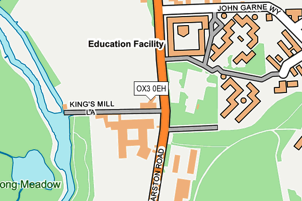
OX3 0EH is located in the Marston electoral ward, within the local authority district of Oxford and the English Parliamentary constituency of Oxford East. The Sub Integrated Care Board (ICB) Location is NHS Buckinghamshire, Oxfordshire and Berkshire West ICB - 10Q and the police force is Thames Valley. This postcode has been in use since January 1980.


GetTheData
Source: OS OpenMap – Local (Ordnance Survey)
Source: OS VectorMap District (Ordnance Survey)
Licence: Open Government Licence (requires attribution)
| Easting | 452835 |
| Northing | 206686 |
| Latitude | 51.756379 |
| Longitude | -1.235945 |
GetTheData
Source: Open Postcode Geo
Licence: Open Government Licence
| Country | England |
| Postcode District | OX3 |
➜ See where OX3 is on a map ➜ Where is Oxford? | |
GetTheData
Source: Land Registry Price Paid Data
Licence: Open Government Licence
Elevation or altitude of OX3 0EH as distance above sea level:
| Metres | Feet | |
|---|---|---|
| Elevation | 60m | 197ft |
Elevation is measured from the approximate centre of the postcode, to the nearest point on an OS contour line from OS Terrain 50, which has contour spacing of ten vertical metres.
➜ How high above sea level am I? Find the elevation of your current position using your device's GPS.
GetTheData
Source: Open Postcode Elevation
Licence: Open Government Licence
| Ward | Marston |
| Constituency | Oxford East |
GetTheData
Source: ONS Postcode Database
Licence: Open Government Licence
| Kings Mill Lane (Marston Road) | New Marston | 32m |
| Clive Booth Hall (Marston Road) | New Marston | 55m |
| Clive Booth Hall (Marston Road) | New Marston | 104m |
| The Somerset Ph (Marston Road) | New Marston | 345m |
| Edgeway Road (Marston Road) | New Marston | 434m |
| Oxford Station | 2.4km |
GetTheData
Source: NaPTAN
Licence: Open Government Licence
GetTheData
Source: ONS Postcode Database
Licence: Open Government Licence


➜ Get more ratings from the Food Standards Agency
GetTheData
Source: Food Standards Agency
Licence: FSA terms & conditions
| Last Collection | |||
|---|---|---|---|
| Location | Mon-Fri | Sat | Distance |
| New Marston Post Office | 17:15 | 12:00 | 333m |
| Headington Hill | 17:30 | 11:30 | 555m |
| Cheney Lane | 16:15 | 11:30 | 584m |
GetTheData
Source: Dracos
Licence: Creative Commons Attribution-ShareAlike
The below table lists the International Territorial Level (ITL) codes (formerly Nomenclature of Territorial Units for Statistics (NUTS) codes) and Local Administrative Units (LAU) codes for OX3 0EH:
| ITL 1 Code | Name |
|---|---|
| TLJ | South East (England) |
| ITL 2 Code | Name |
| TLJ1 | Berkshire, Buckinghamshire and Oxfordshire |
| ITL 3 Code | Name |
| TLJ14 | Oxfordshire CC |
| LAU 1 Code | Name |
| E07000178 | Oxford |
GetTheData
Source: ONS Postcode Directory
Licence: Open Government Licence
The below table lists the Census Output Area (OA), Lower Layer Super Output Area (LSOA), and Middle Layer Super Output Area (MSOA) for OX3 0EH:
| Code | Name | |
|---|---|---|
| OA | E00145504 | |
| LSOA | E01028563 | Oxford 004D |
| MSOA | E02005943 | Oxford 004 |
GetTheData
Source: ONS Postcode Directory
Licence: Open Government Licence
| OX3 0TX | John Garne Way | 232m |
| OX3 0EE | Marston Road | 238m |
| OX3 0EJ | Marston Road | 293m |
| OX3 0HA | Ferry Road | 317m |
| OX3 0EL | Marston Road | 353m |
| OX3 0ET | Ferry Road | 370m |
| OX3 0EN | Marston Road | 372m |
| OX3 0ER | William Street | 374m |
| OX3 0ED | Headington Road | 381m |
| OX3 0EB | Headington Road | 387m |
GetTheData
Source: Open Postcode Geo; Land Registry Price Paid Data
Licence: Open Government Licence