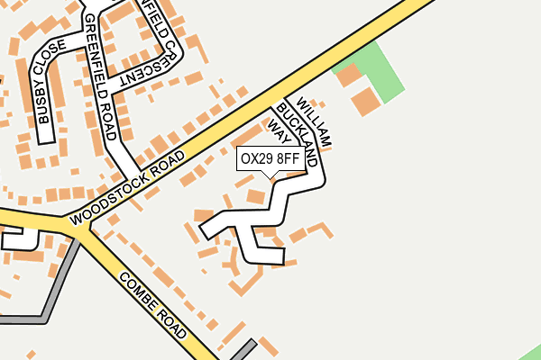
OX29 8FF is located in the Stonesfield and Tackley electoral ward, within the local authority district of West Oxfordshire and the English Parliamentary constituency of Witney. The Sub Integrated Care Board (ICB) Location is NHS Buckinghamshire, Oxfordshire and Berkshire West ICB - 10Q and the police force is Thames Valley. This postcode has been in use since April 2017.


GetTheData
Source: OS OpenMap – Local (Ordnance Survey)
Source: OS VectorMap District (Ordnance Survey)
Licence: Open Government Licence (requires attribution)
| Easting | 439756 |
| Northing | 217215 |
| Latitude | 51.852126 |
| Longitude | -1.424196 |
GetTheData
Source: Open Postcode Geo
Licence: Open Government Licence
| Country | England |
| Postcode District | OX29 |
➜ See where OX29 is on a map ➜ Where is Stonesfield? | |
GetTheData
Source: Land Registry Price Paid Data
Licence: Open Government Licence
| Ward | Stonesfield And Tackley |
| Constituency | Witney |
GetTheData
Source: ONS Postcode Database
Licence: Open Government Licence
2021 2 JUN £750,000 |
9, WILLIAM BUCKLAND WAY, STONESFIELD, WITNEY, OX29 8FF 2020 10 NOV £622,500 |
11, WILLIAM BUCKLAND WAY, STONESFIELD, WITNEY, OX29 8FF 2019 12 AUG £520,000 |
3, WILLIAM BUCKLAND WAY, STONESFIELD, WITNEY, OX29 8FF 2018 23 NOV £972,500 |
5, WILLIAM BUCKLAND WAY, STONESFIELD, WITNEY, OX29 8FF 2018 9 NOV £850,000 |
7, WILLIAM BUCKLAND WAY, STONESFIELD, WITNEY, OX29 8FF 2018 24 OCT £835,000 |
22, WILLIAM BUCKLAND WAY, STONESFIELD, WITNEY, OX29 8FF 2018 4 MAY £860,000 |
2018 19 MAR £675,000 |
20, WILLIAM BUCKLAND WAY, STONESFIELD, WITNEY, OX29 8FF 2017 14 NOV £725,000 |
1, WILLIAM BUCKLAND WAY, STONESFIELD, WITNEY, OX29 8FF 2017 31 JUL £765,000 |
GetTheData
Source: HM Land Registry Price Paid Data
Licence: Contains HM Land Registry data © Crown copyright and database right 2025. This data is licensed under the Open Government Licence v3.0.
| Combe Road | Stonesfield | 181m |
| Combe Road | Stonesfield | 203m |
| Prospect Close (Woodstock Road) | Stonesfield | 255m |
| Prospect Close (Woodstock Road) | Stonesfield | 277m |
| Green (Pond Hill) | Stonesfield | 546m |
| Combe (Oxon) Station | 3km |
| Finstock Station | 3.1km |
| Hanborough Station | 4.6km |
GetTheData
Source: NaPTAN
Licence: Open Government Licence
| Percentage of properties with Next Generation Access | 100.0% |
| Percentage of properties with Superfast Broadband | 100.0% |
| Percentage of properties with Ultrafast Broadband | 0.0% |
| Percentage of properties with Full Fibre Broadband | 0.0% |
Superfast Broadband is between 30Mbps and 300Mbps
Ultrafast Broadband is > 300Mbps
| Median download speed | 66.7Mbps |
| Average download speed | 57.9Mbps |
| Maximum download speed | 80.00Mbps |
| Median upload speed | 15.6Mbps |
| Average upload speed | 13.7Mbps |
| Maximum upload speed | 20.00Mbps |
| Percentage of properties unable to receive 2Mbps | 0.0% |
| Percentage of properties unable to receive 5Mbps | 0.0% |
| Percentage of properties unable to receive 10Mbps | 0.0% |
| Percentage of properties unable to receive 30Mbps | 0.0% |
GetTheData
Source: Ofcom
Licence: Ofcom Terms of Use (requires attribution)
GetTheData
Source: ONS Postcode Database
Licence: Open Government Licence


➜ Get more ratings from the Food Standards Agency
GetTheData
Source: Food Standards Agency
Licence: FSA terms & conditions
| Last Collection | |||
|---|---|---|---|
| Location | Mon-Fri | Sat | Distance |
| Stonefield Post Office | 16:15 | 09:00 | 397m |
| Churchfields | 16:15 | 09:15 | 542m |
| Fawler | 16:00 | 07:00 | 2,695m |
GetTheData
Source: Dracos
Licence: Creative Commons Attribution-ShareAlike
The below table lists the International Territorial Level (ITL) codes (formerly Nomenclature of Territorial Units for Statistics (NUTS) codes) and Local Administrative Units (LAU) codes for OX29 8FF:
| ITL 1 Code | Name |
|---|---|
| TLJ | South East (England) |
| ITL 2 Code | Name |
| TLJ1 | Berkshire, Buckinghamshire and Oxfordshire |
| ITL 3 Code | Name |
| TLJ14 | Oxfordshire CC |
| LAU 1 Code | Name |
| E07000181 | West Oxfordshire |
GetTheData
Source: ONS Postcode Directory
Licence: Open Government Licence
The below table lists the Census Output Area (OA), Lower Layer Super Output Area (LSOA), and Middle Layer Super Output Area (MSOA) for OX29 8FF:
| Code | Name | |
|---|---|---|
| OA | E00146709 | |
| LSOA | E01028804 | West Oxfordshire 004B |
| MSOA | E02005996 | West Oxfordshire 004 |
GetTheData
Source: ONS Postcode Directory
Licence: Open Government Licence
| OX29 8EJ | Woodstock Road | 113m |
| OX29 8QB | Combe Road | 140m |
| OX29 8QD | Combe Road | 159m |
| OX29 8EH | Greenfield Crescent | 216m |
| OX29 8EQ | Greenfield Road | 234m |
| OX29 8QA | Woodstock Road | 244m |
| OX29 8EU | Busby Close | 248m |
| OX29 8QE | Prospect Close | 264m |
| OX29 8QW | St James Court | 303m |
| OX29 8QN | Pond Hill | 334m |
GetTheData
Source: Open Postcode Geo; Land Registry Price Paid Data
Licence: Open Government Licence