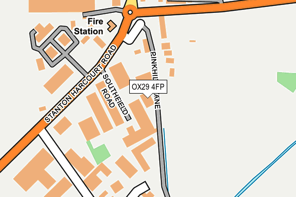
OX29 4FP is located in the Eynsham and Cassington electoral ward, within the local authority district of West Oxfordshire and the English Parliamentary constituency of Witney. The Sub Integrated Care Board (ICB) Location is NHS Buckinghamshire, Oxfordshire and Berkshire West ICB - 10Q and the police force is Thames Valley. This postcode has been in use since June 2017.


GetTheData
Source: OS OpenMap – Local (Ordnance Survey)
Source: OS VectorMap District (Ordnance Survey)
Licence: Open Government Licence (requires attribution)
| Easting | 443070 |
| Northing | 208667 |
| Latitude | 51.775028 |
| Longitude | -1.377145 |
GetTheData
Source: Open Postcode Geo
Licence: Open Government Licence
| Country | England |
| Postcode District | OX29 |
➜ See where OX29 is on a map ➜ Where is Eynsham? | |
GetTheData
Source: Land Registry Price Paid Data
Licence: Open Government Licence
| Ward | Eynsham And Cassington |
| Constituency | Witney |
GetTheData
Source: ONS Postcode Database
Licence: Open Government Licence
| Oakfields Industrial Estate (B4449) | Eynsham | 186m |
| Oakfields Industrial Estate (B4449) | Eynsham | 203m |
| Swan Street (Station Road) | Eynsham | 528m |
| Swan Street (Station Road) | Eynsham | 544m |
| Swan Hotel (Acre End Street) | Eynsham | 613m |
GetTheData
Source: NaPTAN
Licence: Open Government Licence
| Percentage of properties with Next Generation Access | 0.0% |
| Percentage of properties with Superfast Broadband | 0.0% |
| Percentage of properties with Ultrafast Broadband | 0.0% |
| Percentage of properties with Full Fibre Broadband | 0.0% |
Superfast Broadband is between 30Mbps and 300Mbps
Ultrafast Broadband is > 300Mbps
| Percentage of properties unable to receive 2Mbps | 0.0% |
| Percentage of properties unable to receive 5Mbps | 0.0% |
| Percentage of properties unable to receive 10Mbps | 0.0% |
| Percentage of properties unable to receive 30Mbps | 100.0% |
GetTheData
Source: Ofcom
Licence: Ofcom Terms of Use (requires attribution)
GetTheData
Source: ONS Postcode Database
Licence: Open Government Licence


➜ Get more ratings from the Food Standards Agency
GetTheData
Source: Food Standards Agency
Licence: FSA terms & conditions
| Last Collection | |||
|---|---|---|---|
| Location | Mon-Fri | Sat | Distance |
| Acre End Street | 17:00 | 09:45 | 622m |
| The Square | 17:00 | 09:45 | 632m |
| Eynsham Post Office | 18:30 | 11:20 | 790m |
GetTheData
Source: Dracos
Licence: Creative Commons Attribution-ShareAlike
The below table lists the International Territorial Level (ITL) codes (formerly Nomenclature of Territorial Units for Statistics (NUTS) codes) and Local Administrative Units (LAU) codes for OX29 4FP:
| ITL 1 Code | Name |
|---|---|
| TLJ | South East (England) |
| ITL 2 Code | Name |
| TLJ1 | Berkshire, Buckinghamshire and Oxfordshire |
| ITL 3 Code | Name |
| TLJ14 | Oxfordshire CC |
| LAU 1 Code | Name |
| E07000181 | West Oxfordshire |
GetTheData
Source: ONS Postcode Directory
Licence: Open Government Licence
The below table lists the Census Output Area (OA), Lower Layer Super Output Area (LSOA), and Middle Layer Super Output Area (MSOA) for OX29 4FP:
| Code | Name | |
|---|---|---|
| OA | E00146623 | |
| LSOA | E01028787 | West Oxfordshire 011C |
| MSOA | E02006003 | West Oxfordshire 011 |
GetTheData
Source: ONS Postcode Directory
Licence: Open Government Licence
| OX29 4JB | Southfield Road | 77m |
| OX29 4JG | Pink Hill Lane | 113m |
| OX29 4TH | Oakfield Industrial Estate | 264m |
| OX29 4XH | Station Road | 271m |
| OX29 4HX | Station Road | 297m |
| OX29 4FA | Station Road | 479m |
| OX29 4HR | Abbey Street | 531m |
| OX29 4HZ | Hey Croft | 543m |
| OX29 4NX | Acre End Street | 565m |
| OX29 4HD | Swan Street | 574m |
GetTheData
Source: Open Postcode Geo; Land Registry Price Paid Data
Licence: Open Government Licence