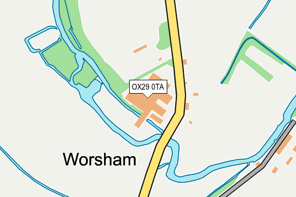
OX29 0TA is located in the Brize Norton and Shilton electoral ward, within the local authority district of West Oxfordshire and the English Parliamentary constituency of Witney. The Sub Integrated Care Board (ICB) Location is NHS Buckinghamshire, Oxfordshire and Berkshire West ICB - 10Q and the police force is Thames Valley. This postcode has been in use since June 2001.


GetTheData
Source: OS OpenMap – Local (Ordnance Survey)
Source: OS VectorMap District (Ordnance Survey)
Licence: Open Government Licence (requires attribution)
| Easting | 429869 |
| Northing | 210712 |
| Latitude | 51.794267 |
| Longitude | -1.568310 |
GetTheData
Source: Open Postcode Geo
Licence: Open Government Licence
| Country | England |
| Postcode District | OX29 |
➜ See where OX29 is on a map ➜ Where is Worsham? | |
GetTheData
Source: Land Registry Price Paid Data
Licence: Open Government Licence
Elevation or altitude of OX29 0TA as distance above sea level:
| Metres | Feet | |
|---|---|---|
| Elevation | 100m | 328ft |
Elevation is measured from the approximate centre of the postcode, to the nearest point on an OS contour line from OS Terrain 50, which has contour spacing of ten vertical metres.
➜ How high above sea level am I? Find the elevation of your current position using your device's GPS.
GetTheData
Source: Open Postcode Elevation
Licence: Open Government Licence
| Ward | Brize Norton And Shilton |
| Constituency | Witney |
GetTheData
Source: ONS Postcode Database
Licence: Open Government Licence
| Worsham Turn (Burford Road) | Worsham | 560m |
| Worsham Turn (Burford Road) | Worsham | 562m |
| Asthall Turn (Burford Road) | Asthall | 991m |
| Asthall Turn (Burford Road) | Asthall | 994m |
| The Maytime Ph (Unclassified) | Asthall | 1,203m |
GetTheData
Source: NaPTAN
Licence: Open Government Licence
GetTheData
Source: ONS Postcode Database
Licence: Open Government Licence


➜ Get more ratings from the Food Standards Agency
GetTheData
Source: Food Standards Agency
Licence: FSA terms & conditions
| Last Collection | |||
|---|---|---|---|
| Location | Mon-Fri | Sat | Distance |
| Brize Norton Road | 16:45 | 08:15 | 1,371m |
| Minster Lovell Post Office | 16:45 | 09:45 | 1,576m |
| Asthall Leigh | 16:00 | 09:00 | 2,148m |
GetTheData
Source: Dracos
Licence: Creative Commons Attribution-ShareAlike
| Risk of OX29 0TA flooding from rivers and sea | Medium |
| ➜ OX29 0TA flood map | |
GetTheData
Source: Open Flood Risk by Postcode
Licence: Open Government Licence
The below table lists the International Territorial Level (ITL) codes (formerly Nomenclature of Territorial Units for Statistics (NUTS) codes) and Local Administrative Units (LAU) codes for OX29 0TA:
| ITL 1 Code | Name |
|---|---|
| TLJ | South East (England) |
| ITL 2 Code | Name |
| TLJ1 | Berkshire, Buckinghamshire and Oxfordshire |
| ITL 3 Code | Name |
| TLJ14 | Oxfordshire CC |
| LAU 1 Code | Name |
| E07000181 | West Oxfordshire |
GetTheData
Source: ONS Postcode Directory
Licence: Open Government Licence
The below table lists the Census Output Area (OA), Lower Layer Super Output Area (LSOA), and Middle Layer Super Output Area (MSOA) for OX29 0TA:
| Code | Name | |
|---|---|---|
| OA | E00146516 | |
| LSOA | E01028766 | West Oxfordshire 012B |
| MSOA | E02006004 | West Oxfordshire 012 |
GetTheData
Source: ONS Postcode Directory
Licence: Open Government Licence
| OX29 0RX | 81m | |
| OX29 0AD | 288m | |
| OX29 0RU | Burford Road | 878m |
| OX18 4HH | 1091m | |
| OX29 0SB | Whitehall Close | 1109m |
| OX18 4HN | Walkers Close | 1132m |
| OX29 0SA | Lovell Close | 1151m |
| OX29 0RQ | Wenrisc Drive | 1164m |
| OX18 4HW | 1210m | |
| OX29 0RP | Ripley Avenue | 1214m |
GetTheData
Source: Open Postcode Geo; Land Registry Price Paid Data
Licence: Open Government Licence