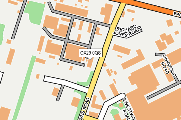
OX29 0QS lies on Minster Industrial Estate in Witney. OX29 0QS is located in the Ducklington electoral ward, within the local authority district of West Oxfordshire and the English Parliamentary constituency of Witney. The Sub Integrated Care Board (ICB) Location is NHS Buckinghamshire, Oxfordshire and Berkshire West ICB - 10Q and the police force is Thames Valley. This postcode has been in use since June 2001.


GetTheData
Source: OS OpenMap – Local (Ordnance Survey)
Source: OS VectorMap District (Ordnance Survey)
Licence: Open Government Licence (requires attribution)
| Easting | 432993 |
| Northing | 210438 |
| Latitude | 51.791634 |
| Longitude | -1.523025 |
GetTheData
Source: Open Postcode Geo
Licence: Open Government Licence
| Street | Minster Industrial Estate |
| Town/City | Witney |
| Country | England |
| Postcode District | OX29 |
➜ See where OX29 is on a map ➜ Where is Witney? | |
GetTheData
Source: Land Registry Price Paid Data
Licence: Open Government Licence
Elevation or altitude of OX29 0QS as distance above sea level:
| Metres | Feet | |
|---|---|---|
| Elevation | 110m | 361ft |
Elevation is measured from the approximate centre of the postcode, to the nearest point on an OS contour line from OS Terrain 50, which has contour spacing of ten vertical metres.
➜ How high above sea level am I? Find the elevation of your current position using your device's GPS.
GetTheData
Source: Open Postcode Elevation
Licence: Open Government Licence
| Ward | Ducklington |
| Constituency | Witney |
GetTheData
Source: ONS Postcode Database
Licence: Open Government Licence
| Downs Road (Burford Road B4074) | Witney | 235m |
| Downs Road (Burford Road B4074) | Witney | 264m |
| Abbott Diabetes Care (Range Road) | Witney | 499m |
| Windrush Industrial Park (Burford Road) | Witney | 598m |
| Windrush Industrial Park (Burford Road) | Witney | 654m |
GetTheData
Source: NaPTAN
Licence: Open Government Licence
GetTheData
Source: ONS Postcode Database
Licence: Open Government Licence


➜ Get more ratings from the Food Standards Agency
GetTheData
Source: Food Standards Agency
Licence: FSA terms & conditions
| Last Collection | |||
|---|---|---|---|
| Location | Mon-Fri | Sat | Distance |
| Minster Lovell Post Office | 16:45 | 09:45 | 1,636m |
| Brize Norton Road | 16:45 | 08:15 | 1,769m |
| Burwell Farm Post Office | 17:00 | 12:00 | 2,250m |
GetTheData
Source: Dracos
Licence: Creative Commons Attribution-ShareAlike
The below table lists the International Territorial Level (ITL) codes (formerly Nomenclature of Territorial Units for Statistics (NUTS) codes) and Local Administrative Units (LAU) codes for OX29 0QS:
| ITL 1 Code | Name |
|---|---|
| TLJ | South East (England) |
| ITL 2 Code | Name |
| TLJ1 | Berkshire, Buckinghamshire and Oxfordshire |
| ITL 3 Code | Name |
| TLJ14 | Oxfordshire CC |
| LAU 1 Code | Name |
| E07000181 | West Oxfordshire |
GetTheData
Source: ONS Postcode Directory
Licence: Open Government Licence
The below table lists the Census Output Area (OA), Lower Layer Super Output Area (LSOA), and Middle Layer Super Output Area (MSOA) for OX29 0QS:
| Code | Name | |
|---|---|---|
| OA | E00146610 | |
| LSOA | E01028784 | West Oxfordshire 007A |
| MSOA | E02005999 | West Oxfordshire 007 |
GetTheData
Source: ONS Postcode Directory
Licence: Open Government Licence
| OX29 0RF | Downs Road | 101m |
| OX29 0RB | Burford Road | 284m |
| OX29 0AA | 319m | |
| OX29 0RD | Burford Road | 343m |
| OX29 0YN | Range Road | 420m |
| OX28 5FT | Valence Crescent | 916m |
| OX28 5GS | Snowshill Drive | 922m |
| OX28 5GG | Broadway Close | 931m |
| OX28 5GT | Snowshill Drive | 932m |
| OX28 5GA | Stanway Close | 945m |
GetTheData
Source: Open Postcode Geo; Land Registry Price Paid Data
Licence: Open Government Licence