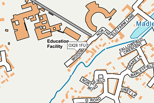
OX28 1FU is located in the Witney East electoral ward, within the local authority district of West Oxfordshire and the English Parliamentary constituency of Witney. The Sub Integrated Care Board (ICB) Location is NHS Buckinghamshire, Oxfordshire and Berkshire West ICB - 10Q and the police force is Thames Valley. This postcode has been in use since February 2017.


GetTheData
Source: OS OpenMap – Local (Ordnance Survey)
Source: OS VectorMap District (Ordnance Survey)
Licence: Open Government Licence (requires attribution)
| Easting | 436762 |
| Northing | 210408 |
| Latitude | 51.791130 |
| Longitude | -1.468383 |
GetTheData
Source: Open Postcode Geo
Licence: Open Government Licence
| Country | England |
| Postcode District | OX28 |
➜ See where OX28 is on a map ➜ Where is Witney? | |
GetTheData
Source: Land Registry Price Paid Data
Licence: Open Government Licence
| Ward | Witney East |
| Constituency | Witney |
GetTheData
Source: ONS Postcode Database
Licence: Open Government Licence
2024 15 MAR £695,000 |
2021 4 FEB £690,000 |
2020 23 MAR £595,000 |
2017 5 SEP £600,000 |
9, WOODBANK, WITNEY, OX28 1FU 2017 15 AUG £579,000 |
6, WOODBANK, WITNEY, OX28 1FU 2017 21 APR £649,000 |
2, WOODBANK, WITNEY, OX28 1FU 2017 13 APR £695,000 |
4, WOODBANK, WITNEY, OX28 1FU 2017 12 APR £625,000 |
2017 31 MAR £587,850 |
11, WOODBANK, WITNEY, OX28 1FU 2017 24 MAR £600,000 |
GetTheData
Source: HM Land Registry Price Paid Data
Licence: Contains HM Land Registry data © Crown copyright and database right 2025. This data is licensed under the Open Government Licence v3.0.
| Co-op (Harvest Way) | Madley Park | 280m |
| The Bridge (Harvest Way) | Madley Park | 321m |
| Cedar Drive (Harvest Way) | Madley Park | 347m |
| Cedar Drive (Harvest Way) | Madley Park | 357m |
| Woodgreen School (Woodstock Road) | Witney | 379m |
GetTheData
Source: NaPTAN
Licence: Open Government Licence
| Percentage of properties with Next Generation Access | 100.0% |
| Percentage of properties with Superfast Broadband | 100.0% |
| Percentage of properties with Ultrafast Broadband | 0.0% |
| Percentage of properties with Full Fibre Broadband | 0.0% |
Superfast Broadband is between 30Mbps and 300Mbps
Ultrafast Broadband is > 300Mbps
| Median download speed | 35.9Mbps |
| Average download speed | 36.9Mbps |
| Maximum download speed | 63.86Mbps |
| Median upload speed | 10.0Mbps |
| Average upload speed | 8.8Mbps |
| Maximum upload speed | 15.52Mbps |
| Percentage of properties unable to receive 2Mbps | 0.0% |
| Percentage of properties unable to receive 5Mbps | 0.0% |
| Percentage of properties unable to receive 10Mbps | 0.0% |
| Percentage of properties unable to receive 30Mbps | 0.0% |
GetTheData
Source: Ofcom
Licence: Ofcom Terms of Use (requires attribution)
GetTheData
Source: ONS Postcode Database
Licence: Open Government Licence


➜ Get more ratings from the Food Standards Agency
GetTheData
Source: Food Standards Agency
Licence: FSA terms & conditions
| Last Collection | |||
|---|---|---|---|
| Location | Mon-Fri | Sat | Distance |
| Madley Park | 16:45 | 09:00 | 283m |
| Woodstock Road | 16:45 | 07:30 | 404m |
| Newlands Post Office | 16:45 | 11:30 | 615m |
GetTheData
Source: Dracos
Licence: Creative Commons Attribution-ShareAlike
The below table lists the International Territorial Level (ITL) codes (formerly Nomenclature of Territorial Units for Statistics (NUTS) codes) and Local Administrative Units (LAU) codes for OX28 1FU:
| ITL 1 Code | Name |
|---|---|
| TLJ | South East (England) |
| ITL 2 Code | Name |
| TLJ1 | Berkshire, Buckinghamshire and Oxfordshire |
| ITL 3 Code | Name |
| TLJ14 | Oxfordshire CC |
| LAU 1 Code | Name |
| E07000181 | West Oxfordshire |
GetTheData
Source: ONS Postcode Directory
Licence: Open Government Licence
The below table lists the Census Output Area (OA), Lower Layer Super Output Area (LSOA), and Middle Layer Super Output Area (MSOA) for OX28 1FU:
| Code | Name | |
|---|---|---|
| OA | E00169066 | |
| LSOA | E01032947 | West Oxfordshire 008G |
| MSOA | E02006000 | West Oxfordshire 008 |
GetTheData
Source: ONS Postcode Directory
Licence: Open Government Licence
| OX28 1FA | Northfield Farm Lane | 81m |
| OX28 1UA | Northfield Farm Lane | 106m |
| OX28 1DW | Northfield Square | 114m |
| OX28 1GB | Waterford Lane | 155m |
| OX28 1FG | Northfield Row | 155m |
| OX28 1FE | Northfield Road | 173m |
| OX28 1FY | Northfield Road | 181m |
| OX28 1BN | Drake Lane | 210m |
| OX28 1FZ | Park View Lane | 219m |
| OX28 1AS | Barleyfield Way | 227m |
GetTheData
Source: Open Postcode Geo; Land Registry Price Paid Data
Licence: Open Government Licence