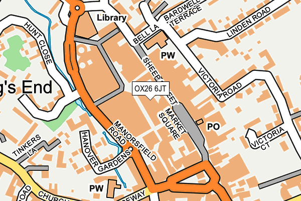
OX26 6JT is located in the Bicester East electoral ward, within the local authority district of Cherwell and the English Parliamentary constituency of Banbury. The Sub Integrated Care Board (ICB) Location is NHS Buckinghamshire, Oxfordshire and Berkshire West ICB - 10Q and the police force is Thames Valley. This postcode has been in use since October 2000.


GetTheData
Source: OS OpenMap – Local (Ordnance Survey)
Source: OS VectorMap District (Ordnance Survey)
Licence: Open Government Licence (requires attribution)
| Easting | 458453 |
| Northing | 222526 |
| Latitude | 51.898223 |
| Longitude | -1.151892 |
GetTheData
Source: Open Postcode Geo
Licence: Open Government Licence
| Country | England |
| Postcode District | OX26 |
➜ See where OX26 is on a map ➜ Where is Bicester? | |
GetTheData
Source: Land Registry Price Paid Data
Licence: Open Government Licence
Elevation or altitude of OX26 6JT as distance above sea level:
| Metres | Feet | |
|---|---|---|
| Elevation | 70m | 230ft |
Elevation is measured from the approximate centre of the postcode, to the nearest point on an OS contour line from OS Terrain 50, which has contour spacing of ten vertical metres.
➜ How high above sea level am I? Find the elevation of your current position using your device's GPS.
GetTheData
Source: Open Postcode Elevation
Licence: Open Government Licence
| Ward | Bicester East |
| Constituency | Banbury |
GetTheData
Source: ONS Postcode Database
Licence: Open Government Licence
| Manorsfield Road | Bicester Town Centre | 109m |
| Queens Avenue | King's End | 368m |
| Queens Avenue | King's End | 382m |
| Community Hospital (Kings End) | King's End | 470m |
| Bicester North Station (Buckingham Road) | Bicester | 536m |
| Bicester North Station | 0.6km |
| Bicester Village Station | 0.6km |
GetTheData
Source: NaPTAN
Licence: Open Government Licence
GetTheData
Source: ONS Postcode Database
Licence: Open Government Licence


➜ Get more ratings from the Food Standards Agency
GetTheData
Source: Food Standards Agency
Licence: FSA terms & conditions
| Last Collection | |||
|---|---|---|---|
| Location | Mon-Fri | Sat | Distance |
| Market Square | 18:30 | 12:00 | 152m |
| Tesco Store | 17:30 | 11:00 | 244m |
| Victoria Road | 17:00 | 11:00 | 247m |
GetTheData
Source: Dracos
Licence: Creative Commons Attribution-ShareAlike
The below table lists the International Territorial Level (ITL) codes (formerly Nomenclature of Territorial Units for Statistics (NUTS) codes) and Local Administrative Units (LAU) codes for OX26 6JT:
| ITL 1 Code | Name |
|---|---|
| TLJ | South East (England) |
| ITL 2 Code | Name |
| TLJ1 | Berkshire, Buckinghamshire and Oxfordshire |
| ITL 3 Code | Name |
| TLJ14 | Oxfordshire CC |
| LAU 1 Code | Name |
| E07000177 | Cherwell |
GetTheData
Source: ONS Postcode Directory
Licence: Open Government Licence
The below table lists the Census Output Area (OA), Lower Layer Super Output Area (LSOA), and Middle Layer Super Output Area (MSOA) for OX26 6JT:
| Code | Name | |
|---|---|---|
| OA | E00145058 | |
| LSOA | E01028468 | Cherwell 015D |
| MSOA | E02005935 | Cherwell 015 |
GetTheData
Source: ONS Postcode Directory
Licence: Open Government Licence
| OX26 6FA | Bure Place | 43m |
| OX26 6JF | Sheep Street | 44m |
| OX26 6LG | Sheep Street | 51m |
| OX26 6HY | Crown Walk | 97m |
| OX26 6JW | Sheep Street | 111m |
| OX26 6JD | Sheep Street | 112m |
| OX26 6EH | Manorsfield Road | 145m |
| OX26 6AD | Market Square | 145m |
| OX26 6PB | Victoria Road | 147m |
| OX26 6PR | Bath Terrace | 169m |
GetTheData
Source: Open Postcode Geo; Land Registry Price Paid Data
Licence: Open Government Licence