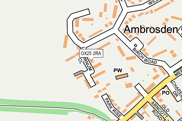
OX25 2RA lies on Chestnut Row in Ambrosden, Bicester. OX25 2RA is located in the Bicester South and Ambrosden electoral ward, within the local authority district of Cherwell and the English Parliamentary constituency of Banbury. The Sub Integrated Care Board (ICB) Location is NHS Buckinghamshire, Oxfordshire and Berkshire West ICB - 10Q and the police force is Thames Valley. This postcode has been in use since February 2007.


GetTheData
Source: OS OpenMap – Local (Ordnance Survey)
Source: OS VectorMap District (Ordnance Survey)
Licence: Open Government Licence (requires attribution)
| Easting | 460202 |
| Northing | 219465 |
| Latitude | 51.870519 |
| Longitude | -1.127010 |
GetTheData
Source: Open Postcode Geo
Licence: Open Government Licence
| Street | Chestnut Row |
| Locality | Ambrosden |
| Town/City | Bicester |
| Country | England |
| Postcode District | OX25 |
➜ See where OX25 is on a map ➜ Where is Ambrosden? | |
GetTheData
Source: Land Registry Price Paid Data
Licence: Open Government Licence
Elevation or altitude of OX25 2RA as distance above sea level:
| Metres | Feet | |
|---|---|---|
| Elevation | 70m | 230ft |
Elevation is measured from the approximate centre of the postcode, to the nearest point on an OS contour line from OS Terrain 50, which has contour spacing of ten vertical metres.
➜ How high above sea level am I? Find the elevation of your current position using your device's GPS.
GetTheData
Source: Open Postcode Elevation
Licence: Open Government Licence
| Ward | Bicester South And Ambrosden |
| Constituency | Banbury |
GetTheData
Source: ONS Postcode Database
Licence: Open Government Licence
| Birch Road (Merton Road) | Ambrosden | 263m |
| Birch Road (Merton Road) | Ambrosden | 277m |
| Ploughley Road Garage (Ploughley Road) | Ambrosden | 375m |
| Ploughley Road Garage (Ploughley Road) | Ambrosden | 382m |
| Willow Road (Ploughley Road) | Ambrosden | 434m |
| Bicester Village Station | 2.9km |
| Bicester North Station | 4km |
GetTheData
Source: NaPTAN
Licence: Open Government Licence
| Percentage of properties with Next Generation Access | 100.0% |
| Percentage of properties with Superfast Broadband | 100.0% |
| Percentage of properties with Ultrafast Broadband | 0.0% |
| Percentage of properties with Full Fibre Broadband | 0.0% |
Superfast Broadband is between 30Mbps and 300Mbps
Ultrafast Broadband is > 300Mbps
| Percentage of properties unable to receive 2Mbps | 0.0% |
| Percentage of properties unable to receive 5Mbps | 0.0% |
| Percentage of properties unable to receive 10Mbps | 0.0% |
| Percentage of properties unable to receive 30Mbps | 0.0% |
GetTheData
Source: Ofcom
Licence: Ofcom Terms of Use (requires attribution)
GetTheData
Source: ONS Postcode Database
Licence: Open Government Licence


➜ Get more ratings from the Food Standards Agency
GetTheData
Source: Food Standards Agency
Licence: FSA terms & conditions
| Last Collection | |||
|---|---|---|---|
| Location | Mon-Fri | Sat | Distance |
| Ambrosden Post Office | 16:30 | 09:15 | 249m |
| Willow Road | 16:30 | 09:30 | 409m |
| Graven Hill | 15:15 | 09:30 | 1,387m |
GetTheData
Source: Dracos
Licence: Creative Commons Attribution-ShareAlike
The below table lists the International Territorial Level (ITL) codes (formerly Nomenclature of Territorial Units for Statistics (NUTS) codes) and Local Administrative Units (LAU) codes for OX25 2RA:
| ITL 1 Code | Name |
|---|---|
| TLJ | South East (England) |
| ITL 2 Code | Name |
| TLJ1 | Berkshire, Buckinghamshire and Oxfordshire |
| ITL 3 Code | Name |
| TLJ14 | Oxfordshire CC |
| LAU 1 Code | Name |
| E07000177 | Cherwell |
GetTheData
Source: ONS Postcode Directory
Licence: Open Government Licence
The below table lists the Census Output Area (OA), Lower Layer Super Output Area (LSOA), and Middle Layer Super Output Area (MSOA) for OX25 2RA:
| Code | Name | |
|---|---|---|
| OA | E00169028 | |
| LSOA | E01028425 | Cherwell 011A |
| MSOA | E02005931 | Cherwell 011 |
GetTheData
Source: ONS Postcode Directory
Licence: Open Government Licence
| OX25 2RT | Willow Road | 22m |
| OX25 2RE | Laburnum Close | 51m |
| OX25 2RW | Rowan Close | 71m |
| OX25 2RU | Willow Road | 106m |
| OX25 2LY | Park Rise | 128m |
| OX25 2RR | Willow Road | 136m |
| OX25 2UJ | Church Walk | 155m |
| OX25 2RF | Willow End | 171m |
| OX25 2RX | Birch Road | 174m |
| OX25 2LW | New Row | 214m |
GetTheData
Source: Open Postcode Geo; Land Registry Price Paid Data
Licence: Open Government Licence