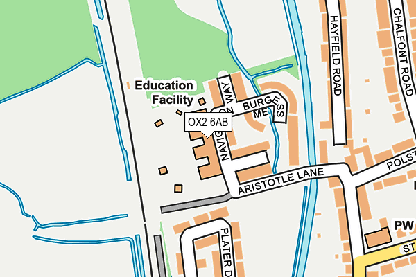
OX2 6AB is located in the Summertown electoral ward, within the local authority district of Oxford and the English Parliamentary constituency of Oxford West and Abingdon. The Sub Integrated Care Board (ICB) Location is NHS Buckinghamshire, Oxfordshire and Berkshire West ICB - 10Q and the police force is Thames Valley. This postcode has been in use since January 2003.


GetTheData
Source: OS OpenMap – Local (Ordnance Survey)
Source: OS VectorMap District (Ordnance Survey)
Licence: Open Government Licence (requires attribution)
| Easting | 450331 |
| Northing | 207956 |
| Latitude | 51.768027 |
| Longitude | -1.272035 |
GetTheData
Source: Open Postcode Geo
Licence: Open Government Licence
| Country | England |
| Postcode District | OX2 |
➜ See where OX2 is on a map ➜ Where is Oxford? | |
GetTheData
Source: Land Registry Price Paid Data
Licence: Open Government Licence
Elevation or altitude of OX2 6AB as distance above sea level:
| Metres | Feet | |
|---|---|---|
| Elevation | 60m | 197ft |
Elevation is measured from the approximate centre of the postcode, to the nearest point on an OS contour line from OS Terrain 50, which has contour spacing of ten vertical metres.
➜ How high above sea level am I? Find the elevation of your current position using your device's GPS.
GetTheData
Source: Open Postcode Elevation
Licence: Open Government Licence
| Ward | Summertown |
| Constituency | Oxford West And Abingdon |
GetTheData
Source: ONS Postcode Database
Licence: Open Government Licence
| Farndon Road (Kingston Road) | Walton Manor | 295m |
| Stone Meadow South (Stone Meadow) | Waterways | 297m |
| Farndon Road (Kingston Road) | Walton Manor | 335m |
| Stone Meadow | Waterways | 407m |
| Stone Meadow | Waterways | 411m |
| Oxford Station | 1.6km |
| Oxford Parkway Station | 4km |
GetTheData
Source: NaPTAN
Licence: Open Government Licence
GetTheData
Source: ONS Postcode Database
Licence: Open Government Licence


➜ Get more ratings from the Food Standards Agency
GetTheData
Source: Food Standards Agency
Licence: FSA terms & conditions
| Last Collection | |||
|---|---|---|---|
| Location | Mon-Fri | Sat | Distance |
| Hayfield Road Post Office | 17:15 | 12:00 | 190m |
| Chalfont Road | 17:15 | 12:00 | 370m |
| Farndon Road | 17:20 | 12:00 | 418m |
GetTheData
Source: Dracos
Licence: Creative Commons Attribution-ShareAlike
The below table lists the International Territorial Level (ITL) codes (formerly Nomenclature of Territorial Units for Statistics (NUTS) codes) and Local Administrative Units (LAU) codes for OX2 6AB:
| ITL 1 Code | Name |
|---|---|
| TLJ | South East (England) |
| ITL 2 Code | Name |
| TLJ1 | Berkshire, Buckinghamshire and Oxfordshire |
| ITL 3 Code | Name |
| TLJ14 | Oxfordshire CC |
| LAU 1 Code | Name |
| E07000178 | Oxford |
GetTheData
Source: ONS Postcode Directory
Licence: Open Government Licence
The below table lists the Census Output Area (OA), Lower Layer Super Output Area (LSOA), and Middle Layer Super Output Area (MSOA) for OX2 6AB:
| Code | Name | |
|---|---|---|
| OA | E00172596 | |
| LSOA | E01028584 | Oxford 003C |
| MSOA | E02005942 | Oxford 003 |
GetTheData
Source: ONS Postcode Directory
Licence: Open Government Licence
| OX2 6XW | Navigation Way | 40m |
| OX2 6XN | Brindley Close | 58m |
| OX2 6XP | Burgess Mead | 128m |
| OX2 6QU | Plater Drive | 155m |
| OX2 6UA | Aristotle Lane | 188m |
| OX2 6QT | Plater Drive | 191m |
| OX2 6TT | Hayfield Road | 200m |
| OX2 6TX | Hayfield Road | 206m |
| OX2 6RL | Kingston Road | 242m |
| OX2 6TU | Hayfield Road | 249m |
GetTheData
Source: Open Postcode Geo; Land Registry Price Paid Data
Licence: Open Government Licence