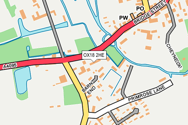
OX18 2HE lies on Mill Green Close in Bampton. OX18 2HE is located in the Bampton and Clanfield electoral ward, within the local authority district of West Oxfordshire and the English Parliamentary constituency of Witney. The Sub Integrated Care Board (ICB) Location is NHS Buckinghamshire, Oxfordshire and Berkshire West ICB - 10Q and the police force is Thames Valley. This postcode has been in use since September 1991.


GetTheData
Source: OS OpenMap – Local (Ordnance Survey)
Source: OS VectorMap District (Ordnance Survey)
Licence: Open Government Licence (requires attribution)
| Easting | 431196 |
| Northing | 202901 |
| Latitude | 51.723968 |
| Longitude | -1.549768 |
GetTheData
Source: Open Postcode Geo
Licence: Open Government Licence
| Street | Mill Green Close |
| Town/City | Bampton |
| Country | England |
| Postcode District | OX18 |
➜ See where OX18 is on a map ➜ Where is Bampton? | |
GetTheData
Source: Land Registry Price Paid Data
Licence: Open Government Licence
Elevation or altitude of OX18 2HE as distance above sea level:
| Metres | Feet | |
|---|---|---|
| Elevation | 70m | 230ft |
Elevation is measured from the approximate centre of the postcode, to the nearest point on an OS contour line from OS Terrain 50, which has contour spacing of ten vertical metres.
➜ How high above sea level am I? Find the elevation of your current position using your device's GPS.
GetTheData
Source: Open Postcode Elevation
Licence: Open Government Licence
| Ward | Bampton And Clanfield |
| Constituency | Witney |
GetTheData
Source: ONS Postcode Database
Licence: Open Government Licence
2019 6 SEP £350,000 |
2000 2 MAR £135,000 |
1997 29 MAY £119,950 |
GetTheData
Source: HM Land Registry Price Paid Data
Licence: Contains HM Land Registry data © Crown copyright and database right 2025. This data is licensed under the Open Government Licence v3.0.
| Bridge Street | Bampton | 325m |
| Bridge Street | Bampton | 347m |
| Market Square | Bampton | 436m |
| Church View (Broad Street) | Bampton | 565m |
| Church View (Broad Street) | Bampton | 580m |
GetTheData
Source: NaPTAN
Licence: Open Government Licence
| Percentage of properties with Next Generation Access | 100.0% |
| Percentage of properties with Superfast Broadband | 100.0% |
| Percentage of properties with Ultrafast Broadband | 71.4% |
| Percentage of properties with Full Fibre Broadband | 0.0% |
Superfast Broadband is between 30Mbps and 300Mbps
Ultrafast Broadband is > 300Mbps
| Median download speed | 41.9Mbps |
| Average download speed | 52.4Mbps |
| Maximum download speed | 100.00Mbps |
| Median upload speed | 6.3Mbps |
| Average upload speed | 5.5Mbps |
| Maximum upload speed | 6.67Mbps |
| Percentage of properties unable to receive 2Mbps | 0.0% |
| Percentage of properties unable to receive 5Mbps | 0.0% |
| Percentage of properties unable to receive 10Mbps | 0.0% |
| Percentage of properties unable to receive 30Mbps | 0.0% |
GetTheData
Source: Ofcom
Licence: Ofcom Terms of Use (requires attribution)
Estimated total energy consumption in OX18 2HE by fuel type, 2015.
| Consumption (kWh) | 111,478 |
|---|---|
| Meter count | 7 |
| Mean (kWh/meter) | 15,925 |
| Median (kWh/meter) | 15,253 |
| Consumption (kWh) | 27,968 |
|---|---|
| Meter count | 7 |
| Mean (kWh/meter) | 3,995 |
| Median (kWh/meter) | 3,003 |
GetTheData
Source: Postcode level gas estimates: 2015 (experimental)
Source: Postcode level electricity estimates: 2015 (experimental)
Licence: Open Government Licence
GetTheData
Source: ONS Postcode Database
Licence: Open Government Licence


➜ Get more ratings from the Food Standards Agency
GetTheData
Source: Food Standards Agency
Licence: FSA terms & conditions
| Last Collection | |||
|---|---|---|---|
| Location | Mon-Fri | Sat | Distance |
| Lew | 16:00 | 07:30 | 3,785m |
| Thorney Leys | 17:15 | 08:00 | 4,047m |
| Carterton Sorting Office | 18:00 | 11:30 | 4,793m |
GetTheData
Source: Dracos
Licence: Creative Commons Attribution-ShareAlike
| Risk of OX18 2HE flooding from rivers and sea | Medium |
| ➜ OX18 2HE flood map | |
GetTheData
Source: Open Flood Risk by Postcode
Licence: Open Government Licence
The below table lists the International Territorial Level (ITL) codes (formerly Nomenclature of Territorial Units for Statistics (NUTS) codes) and Local Administrative Units (LAU) codes for OX18 2HE:
| ITL 1 Code | Name |
|---|---|
| TLJ | South East (England) |
| ITL 2 Code | Name |
| TLJ1 | Berkshire, Buckinghamshire and Oxfordshire |
| ITL 3 Code | Name |
| TLJ14 | Oxfordshire CC |
| LAU 1 Code | Name |
| E07000181 | West Oxfordshire |
GetTheData
Source: ONS Postcode Directory
Licence: Open Government Licence
The below table lists the Census Output Area (OA), Lower Layer Super Output Area (LSOA), and Middle Layer Super Output Area (MSOA) for OX18 2HE:
| Code | Name | |
|---|---|---|
| OA | E00146504 | |
| LSOA | E01028764 | West Oxfordshire 015A |
| MSOA | E02006007 | West Oxfordshire 015 |
GetTheData
Source: ONS Postcode Directory
Licence: Open Government Licence
| OX18 2HF | Mill Green | 61m |
| OX18 2HG | Ham Court Cottages | 90m |
| OX18 2HY | 118m | |
| OX18 2HH | Weald Manor Cottages | 148m |
| OX18 2HA | Bridge Street | 207m |
| OX18 2JA | Primrose Cottages | 226m |
| OX18 2NT | Shrewsbury Place | 256m |
| OX18 2HL | Weald Street | 267m |
| OX18 2NE | Church View | 302m |
| OX18 2HB | Cheyne Lane | 308m |
GetTheData
Source: Open Postcode Geo; Land Registry Price Paid Data
Licence: Open Government Licence