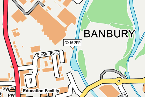
OX16 2PP is located in the Banbury Cross and Neithrop electoral ward, within the local authority district of Cherwell and the English Parliamentary constituency of Banbury. The Sub Integrated Care Board (ICB) Location is NHS Buckinghamshire, Oxfordshire and Berkshire West ICB - 10Q and the police force is Thames Valley. This postcode has been in use since June 2000.


GetTheData
Source: OS OpenMap – Local (Ordnance Survey)
Source: OS VectorMap District (Ordnance Survey)
Licence: Open Government Licence (requires attribution)
| Easting | 445589 |
| Northing | 241095 |
| Latitude | 52.066370 |
| Longitude | -1.336356 |
GetTheData
Source: Open Postcode Geo
Licence: Open Government Licence
| Country | England |
| Postcode District | OX16 |
➜ See where OX16 is on a map ➜ Where is Banbury? | |
GetTheData
Source: Land Registry Price Paid Data
Licence: Open Government Licence
Elevation or altitude of OX16 2PP as distance above sea level:
| Metres | Feet | |
|---|---|---|
| Elevation | 90m | 295ft |
Elevation is measured from the approximate centre of the postcode, to the nearest point on an OS contour line from OS Terrain 50, which has contour spacing of ten vertical metres.
➜ How high above sea level am I? Find the elevation of your current position using your device's GPS.
GetTheData
Source: Open Postcode Elevation
Licence: Open Government Licence
| Ward | Banbury Cross And Neithrop |
| Constituency | Banbury |
GetTheData
Source: ONS Postcode Database
Licence: Open Government Licence
| Coopers Gate (Southam Road) | Banbury | 252m |
| Coopers Gate (Southam Road) | Banbury | 258m |
| Cemetery (Southam Road) | Banbury | 297m |
| Cemetery (Southam Road) | Banbury | 318m |
| Bolton Road (Castle Street) | Banbury Town Centre | 337m |
| Banbury Station | 0.9km |
| Kings Sutton Station | 6.3km |
GetTheData
Source: NaPTAN
Licence: Open Government Licence
GetTheData
Source: ONS Postcode Database
Licence: Open Government Licence


➜ Get more ratings from the Food Standards Agency
GetTheData
Source: Food Standards Agency
Licence: FSA terms & conditions
| Last Collection | |||
|---|---|---|---|
| Location | Mon-Fri | Sat | Distance |
| Market Place | 18:20 | 11:00 | 474m |
| Bridge Street | 18:15 | 11:00 | 519m |
| Banbury Delivery Office | 18:30 | 12:00 | 799m |
GetTheData
Source: Dracos
Licence: Creative Commons Attribution-ShareAlike
| Risk of OX16 2PP flooding from rivers and sea | Medium |
| ➜ OX16 2PP flood map | |
GetTheData
Source: Open Flood Risk by Postcode
Licence: Open Government Licence
The below table lists the International Territorial Level (ITL) codes (formerly Nomenclature of Territorial Units for Statistics (NUTS) codes) and Local Administrative Units (LAU) codes for OX16 2PP:
| ITL 1 Code | Name |
|---|---|
| TLJ | South East (England) |
| ITL 2 Code | Name |
| TLJ1 | Berkshire, Buckinghamshire and Oxfordshire |
| ITL 3 Code | Name |
| TLJ14 | Oxfordshire CC |
| LAU 1 Code | Name |
| E07000177 | Cherwell |
GetTheData
Source: ONS Postcode Directory
Licence: Open Government Licence
The below table lists the Census Output Area (OA), Lower Layer Super Output Area (LSOA), and Middle Layer Super Output Area (MSOA) for OX16 2PP:
| Code | Name | |
|---|---|---|
| OA | E00144900 | |
| LSOA | E01028438 | Cherwell 004D |
| MSOA | E02005924 | Cherwell 004 |
GetTheData
Source: ONS Postcode Directory
Licence: Open Government Licence
| OX16 2WD | Coopers Gate | 113m |
| OX16 2EP | Southam Road | 236m |
| OX16 2EQ | Coopers Gate | 254m |
| OX16 2AZ | School Lane | 260m |
| OX16 2EW | Southam Road | 267m |
| OX16 2AU | School Lane | 277m |
| OX16 5NX | Castle Street | 316m |
| OX16 2AT | School Lane | 318m |
| OX16 5NU | Castle Street | 327m |
| OX16 2EH | Cope Road | 335m |
GetTheData
Source: Open Postcode Geo; Land Registry Price Paid Data
Licence: Open Government Licence