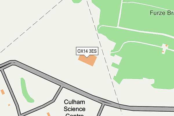
OX14 3ES is located in the Sandford & the Wittenhams electoral ward, within the local authority district of South Oxfordshire and the English Parliamentary constituency of Henley. The Sub Integrated Care Board (ICB) Location is NHS Buckinghamshire, Oxfordshire and Berkshire West ICB - 10Q and the police force is Thames Valley. This postcode has been in use since March 2017.


GetTheData
Source: OS OpenMap – Local (Ordnance Survey)
Source: OS VectorMap District (Ordnance Survey)
Licence: Open Government Licence (requires attribution)
| Easting | 453305 |
| Northing | 196344 |
| Latitude | 51.663360 |
| Longitude | -1.230696 |
GetTheData
Source: Open Postcode Geo
Licence: Open Government Licence
| Country | England |
| Postcode District | OX14 |
➜ See where OX14 is on a map | |
GetTheData
Source: Land Registry Price Paid Data
Licence: Open Government Licence
| Ward | Sandford & The Wittenhams |
| Constituency | Henley |
GetTheData
Source: ONS Postcode Database
Licence: Open Government Licence
| Science Centre (Abingdon Road) | Culham | 1,154m |
| Science Centre (Abingdon Road) | Culham | 1,170m |
| Village Hall (High Street) | Clifton Hampden | 1,519m |
| Village Hall (High Street) | Clifton Hampden | 1,544m |
| Post Office (High Street) | Clifton Hampden | 1,605m |
| Culham Station | 1.1km |
| Radley Station | 2.6km |
| Appleford Station | 2.8km |
GetTheData
Source: NaPTAN
Licence: Open Government Licence
GetTheData
Source: ONS Postcode Database
Licence: Open Government Licence


➜ Get more ratings from the Food Standards Agency
GetTheData
Source: Food Standards Agency
Licence: FSA terms & conditions
| Last Collection | |||
|---|---|---|---|
| Location | Mon-Fri | Sat | Distance |
| Culham Station | 16:00 | 07:30 | 1,116m |
| Clifton Hampden Post Office | 16:15 | 09:30 | 1,634m |
| Thame Lane | 16:00 | 08:15 | 1,961m |
GetTheData
Source: Dracos
Licence: Creative Commons Attribution-ShareAlike
The below table lists the International Territorial Level (ITL) codes (formerly Nomenclature of Territorial Units for Statistics (NUTS) codes) and Local Administrative Units (LAU) codes for OX14 3ES:
| ITL 1 Code | Name |
|---|---|
| TLJ | South East (England) |
| ITL 2 Code | Name |
| TLJ1 | Berkshire, Buckinghamshire and Oxfordshire |
| ITL 3 Code | Name |
| TLJ14 | Oxfordshire CC |
| LAU 1 Code | Name |
| E07000179 | South Oxfordshire |
GetTheData
Source: ONS Postcode Directory
Licence: Open Government Licence
The below table lists the Census Output Area (OA), Lower Layer Super Output Area (LSOA), and Middle Layer Super Output Area (MSOA) for OX14 3ES:
| Code | Name | |
|---|---|---|
| OA | E00145971 | |
| LSOA | E01028658 | South Oxfordshire 006F |
| MSOA | E02005963 | South Oxfordshire 006 |
GetTheData
Source: ONS Postcode Directory
Licence: Open Government Licence
| OX14 3DD | 1109m | |
| OX14 3BT | Station Road | 1134m |
| OX44 9PH | Nuneham Park | 1219m |
| OX14 3DT | Thame Lane | 1373m |
| OX14 3EL | Watery Lane | 1433m |
| OX14 3EN | Courtiers Green | 1434m |
| OX14 3DF | 1475m | |
| OX14 3EJ | Watery Lane | 1499m |
| OX14 3EW | Oxford Road | 1522m |
| OX14 3EQ | High Street | 1523m |
GetTheData
Source: Open Postcode Geo; Land Registry Price Paid Data
Licence: Open Government Licence