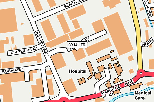
OX14 1TR is located in the Abingdon Fitzharris electoral ward, within the local authority district of Vale of White Horse and the English Parliamentary constituency of Oxford West and Abingdon. The Sub Integrated Care Board (ICB) Location is NHS Buckinghamshire, Oxfordshire and Berkshire West ICB - 10Q and the police force is Thames Valley. This postcode has been in use since February 1984.


GetTheData
Source: OS OpenMap – Local (Ordnance Survey)
Source: OS VectorMap District (Ordnance Survey)
Licence: Open Government Licence (requires attribution)
| Easting | 448283 |
| Northing | 197103 |
| Latitude | 51.670633 |
| Longitude | -1.303212 |
GetTheData
Source: Open Postcode Geo
Licence: Open Government Licence
| Country | England |
| Postcode District | OX14 |
➜ See where OX14 is on a map ➜ Where is Abingdon-on-Thames? | |
GetTheData
Source: Land Registry Price Paid Data
Licence: Open Government Licence
Elevation or altitude of OX14 1TR as distance above sea level:
| Metres | Feet | |
|---|---|---|
| Elevation | 60m | 197ft |
Elevation is measured from the approximate centre of the postcode, to the nearest point on an OS contour line from OS Terrain 50, which has contour spacing of ten vertical metres.
➜ How high above sea level am I? Find the elevation of your current position using your device's GPS.
GetTheData
Source: Open Postcode Elevation
Licence: Open Government Licence
| Ward | Abingdon Fitzharris |
| Constituency | Oxford West And Abingdon |
GetTheData
Source: ONS Postcode Database
Licence: Open Government Licence
| Community Hospital (Marcham Road) | Abingdon | 207m |
| Colwell Drive | Abingdon | 235m |
| Community Hospital (Marcham Road) | Abingdon | 249m |
| Colwell Drive | Abingdon | 261m |
| Abingdon Business Park (Wyndyke Furlong) | Abingdon | 326m |
| Radley Station | 4.7km |
| Culham Station | 5km |
| Appleford Station | 5.5km |
GetTheData
Source: NaPTAN
Licence: Open Government Licence
| Median download speed | 26.3Mbps |
| Average download speed | 38.4Mbps |
| Maximum download speed | 80.00Mbps |
| Median upload speed | 5.6Mbps |
| Average upload speed | 8.9Mbps |
| Maximum upload speed | 20.00Mbps |
GetTheData
Source: Ofcom
Licence: Ofcom Terms of Use (requires attribution)
Estimated total energy consumption in OX14 1TR by fuel type, 2015.
| Consumption (kWh) | 204,695 |
|---|---|
| Meter count | 9 |
| Mean (kWh/meter) | 22,744 |
| Median (kWh/meter) | 17,533 |
GetTheData
Source: Postcode level gas estimates: 2015 (experimental)
Source: Postcode level electricity estimates: 2015 (experimental)
Licence: Open Government Licence
GetTheData
Source: ONS Postcode Database
Licence: Open Government Licence


➜ Get more ratings from the Food Standards Agency
GetTheData
Source: Food Standards Agency
Licence: FSA terms & conditions
| Last Collection | |||
|---|---|---|---|
| Location | Mon-Fri | Sat | Distance |
| Nuffield Way | 18:00 | 08:30 | 116m |
| Abingdon Business Park | 18:00 | 262m | |
| Blacklands Way | 18:00 | 08:30 | 267m |
GetTheData
Source: Dracos
Licence: Creative Commons Attribution-ShareAlike
The below table lists the International Territorial Level (ITL) codes (formerly Nomenclature of Territorial Units for Statistics (NUTS) codes) and Local Administrative Units (LAU) codes for OX14 1TR:
| ITL 1 Code | Name |
|---|---|
| TLJ | South East (England) |
| ITL 2 Code | Name |
| TLJ1 | Berkshire, Buckinghamshire and Oxfordshire |
| ITL 3 Code | Name |
| TLJ14 | Oxfordshire CC |
| LAU 1 Code | Name |
| E07000180 | Vale of White Horse |
GetTheData
Source: ONS Postcode Directory
Licence: Open Government Licence
The below table lists the Census Output Area (OA), Lower Layer Super Output Area (LSOA), and Middle Layer Super Output Area (MSOA) for OX14 1TR:
| Code | Name | |
|---|---|---|
| OA | E00146158 | |
| LSOA | E01028698 | Vale of White Horse 006D |
| MSOA | E02005983 | Vale of White Horse 006 |
GetTheData
Source: ONS Postcode Directory
Licence: Open Government Licence
| OX14 1AF | Marcham Road | 226m |
| OX14 1SG | Kimber Road | 278m |
| OX14 1UW | Willow Brook | 288m |
| OX14 1TB | Willow Brook | 321m |
| OX14 1GQ | Thornley Close | 321m |
| OX14 1TD | Willow Brook | 349m |
| OX14 1UL | Willow Brook | 351m |
| OX14 1TF | Anna Pavlova Close | 418m |
| OX14 1GN | Cemetery Road | 419m |
| OX14 1TE | Anna Pavlova Close | 430m |
GetTheData
Source: Open Postcode Geo; Land Registry Price Paid Data
Licence: Open Government Licence