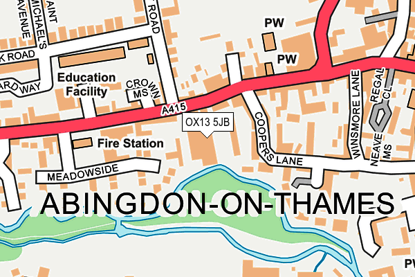
OX13 5JB is located in the Abingdon Caldecott electoral ward, within the local authority district of Vale of White Horse and the English Parliamentary constituency of Oxford West and Abingdon. The Sub Integrated Care Board (ICB) Location is NHS Buckinghamshire, Oxfordshire and Berkshire West ICB - 10Q and the police force is Thames Valley. This postcode has been in use since June 2001.


GetTheData
Source: OS OpenMap – Local (Ordnance Survey)
Source: OS VectorMap District (Ordnance Survey)
Licence: Open Government Licence (requires attribution)
| Easting | 449357 |
| Northing | 196955 |
| Latitude | 51.669210 |
| Longitude | -1.287703 |
GetTheData
Source: Open Postcode Geo
Licence: Open Government Licence
| Country | England |
| Postcode District | OX13 |
➜ See where OX13 is on a map ➜ Where is Abingdon-on-Thames? | |
GetTheData
Source: Land Registry Price Paid Data
Licence: Open Government Licence
Elevation or altitude of OX13 5JB as distance above sea level:
| Metres | Feet | |
|---|---|---|
| Elevation | 50m | 164ft |
Elevation is measured from the approximate centre of the postcode, to the nearest point on an OS contour line from OS Terrain 50, which has contour spacing of ten vertical metres.
➜ How high above sea level am I? Find the elevation of your current position using your device's GPS.
GetTheData
Source: Open Postcode Elevation
Licence: Open Government Licence
| Ward | Abingdon Caldecott |
| Constituency | Oxford West And Abingdon |
GetTheData
Source: ONS Postcode Database
Licence: Open Government Licence
| Conduit Road (Ock Street) | Abingdon | 62m |
| Conduit Road (Ock Street) | Abingdon | 86m |
| Coxeters (Ock Street) | Abingdon Town Centre | 150m |
| Stratton Way | Abingdon Town Centre | 264m |
| Stratton Way | Abingdon Town Centre | 276m |
| Radley Station | 3.8km |
| Culham Station | 3.9km |
| Appleford Station | 4.6km |
GetTheData
Source: NaPTAN
Licence: Open Government Licence
GetTheData
Source: ONS Postcode Database
Licence: Open Government Licence


➜ Get more ratings from the Food Standards Agency
GetTheData
Source: Food Standards Agency
Licence: FSA terms & conditions
| Last Collection | |||
|---|---|---|---|
| Location | Mon-Fri | Sat | Distance |
| Abingdon Delivery Office | 18:30 | 12:15 | 25m |
| Conduit Road | 17:30 | 08:30 | 91m |
| Co-op Stores | 18:15 | 12:15 | 323m |
GetTheData
Source: Dracos
Licence: Creative Commons Attribution-ShareAlike
The below table lists the International Territorial Level (ITL) codes (formerly Nomenclature of Territorial Units for Statistics (NUTS) codes) and Local Administrative Units (LAU) codes for OX13 5JB:
| ITL 1 Code | Name |
|---|---|
| TLJ | South East (England) |
| ITL 2 Code | Name |
| TLJ1 | Berkshire, Buckinghamshire and Oxfordshire |
| ITL 3 Code | Name |
| TLJ14 | Oxfordshire CC |
| LAU 1 Code | Name |
| E07000180 | Vale of White Horse |
GetTheData
Source: ONS Postcode Directory
Licence: Open Government Licence
The below table lists the Census Output Area (OA), Lower Layer Super Output Area (LSOA), and Middle Layer Super Output Area (MSOA) for OX13 5JB:
| Code | Name | |
|---|---|---|
| OA | E00146195 | |
| LSOA | E01028703 | Vale of White Horse 006F |
| MSOA | E02005983 | Vale of White Horse 006 |
GetTheData
Source: ONS Postcode Directory
Licence: Open Government Licence
| OX14 5GW | Coopers Lane | 68m |
| OX14 5AU | Ock Mews | 86m |
| OX14 5AG | Ock Street | 98m |
| OX14 5SL | Meadowside | 99m |
| OX14 5BZ | Ock Street | 102m |
| OX14 5DX | Meadowside | 113m |
| OX14 5GU | Coopers Lane | 116m |
| OX14 5DS | Crown Mews | 118m |
| OX14 5BN | Coopers Lane | 123m |
| OX14 5DH | Ock Street | 124m |
GetTheData
Source: Open Postcode Geo; Land Registry Price Paid Data
Licence: Open Government Licence