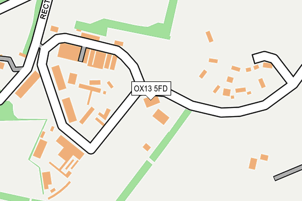
OX13 5FD is located in the Kingston Bagpuize electoral ward, within the local authority district of Vale of White Horse and the English Parliamentary constituency of Wantage. The Sub Integrated Care Board (ICB) Location is NHS Buckinghamshire, Oxfordshire and Berkshire West ICB - 10Q and the police force is Thames Valley. This postcode has been in use since February 2005.


GetTheData
Source: OS OpenMap – Local (Ordnance Survey)
Source: OS VectorMap District (Ordnance Survey)
Licence: Open Government Licence (requires attribution)
| Easting | 441092 |
| Northing | 197562 |
| Latitude | 51.675334 |
| Longitude | -1.407118 |
GetTheData
Source: Open Postcode Geo
Licence: Open Government Licence
| Country | England |
| Postcode District | OX13 |
➜ See where OX13 is on a map | |
GetTheData
Source: Land Registry Price Paid Data
Licence: Open Government Licence
Elevation or altitude of OX13 5FD as distance above sea level:
| Metres | Feet | |
|---|---|---|
| Elevation | 80m | 262ft |
Elevation is measured from the approximate centre of the postcode, to the nearest point on an OS contour line from OS Terrain 50, which has contour spacing of ten vertical metres.
➜ How high above sea level am I? Find the elevation of your current position using your device's GPS.
GetTheData
Source: Open Postcode Elevation
Licence: Open Government Licence
| Ward | Kingston Bagpuize |
| Constituency | Wantage |
GetTheData
Source: ONS Postcode Database
Licence: Open Government Licence
| Kingston Business Park (A415) | Kingston Bagpuize | 388m |
| Kingston Business Park (A415) | Kingston Bagpuize | 465m |
| Frax Close (A415) | Kingston Bagpuize | 794m |
| Frax Close (A415) | Kingston Bagpuize | 805m |
| School Lane (Faringdon Road) | Kingston Bagpuize | 867m |
GetTheData
Source: NaPTAN
Licence: Open Government Licence
GetTheData
Source: ONS Postcode Database
Licence: Open Government Licence


➜ Get more ratings from the Food Standards Agency
GetTheData
Source: Food Standards Agency
Licence: FSA terms & conditions
| Last Collection | |||
|---|---|---|---|
| Location | Mon-Fri | Sat | Distance |
| Kingston Bagpuize | 17:00 | 09:30 | 948m |
| Kingston Bagpuize Post Office | 17:00 | 09:30 | 988m |
| Cherry Tree Close | 16:30 | 08:45 | 1,396m |
GetTheData
Source: Dracos
Licence: Creative Commons Attribution-ShareAlike
The below table lists the International Territorial Level (ITL) codes (formerly Nomenclature of Territorial Units for Statistics (NUTS) codes) and Local Administrative Units (LAU) codes for OX13 5FD:
| ITL 1 Code | Name |
|---|---|
| TLJ | South East (England) |
| ITL 2 Code | Name |
| TLJ1 | Berkshire, Buckinghamshire and Oxfordshire |
| ITL 3 Code | Name |
| TLJ14 | Oxfordshire CC |
| LAU 1 Code | Name |
| E07000180 | Vale of White Horse |
GetTheData
Source: ONS Postcode Directory
Licence: Open Government Licence
The below table lists the Census Output Area (OA), Lower Layer Super Output Area (LSOA), and Middle Layer Super Output Area (MSOA) for OX13 5FD:
| Code | Name | |
|---|---|---|
| OA | E00146365 | |
| LSOA | E01028736 | Vale of White Horse 007B |
| MSOA | E02005984 | Vale of White Horse 007 |
GetTheData
Source: ONS Postcode Directory
Licence: Open Government Licence
| OX13 5AT | Rectory Lane | 271m |
| OX13 5AU | Race Farm Lane | 446m |
| OX13 5DS | Rectory Lane | 488m |
| OX13 5AR | Abingdon Road | 550m |
| OX13 5ND | 581m | |
| OX13 5AY | 756m | |
| OX13 5AZ | Frax Close | 772m |
| OX13 5FZ | Oxford Road | 774m |
| OX13 5AW | Abingdon Road | 785m |
| OX13 5AP | 804m |
GetTheData
Source: Open Postcode Geo; Land Registry Price Paid Data
Licence: Open Government Licence