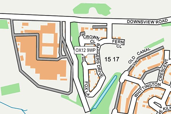
OX12 9WP is located in the Wantage & Grove Brook electoral ward, within the local authority district of Vale of White Horse and the English Parliamentary constituency of Wantage. The Sub Integrated Care Board (ICB) Location is NHS Buckinghamshire, Oxfordshire and Berkshire West ICB - 10Q and the police force is Thames Valley. This postcode has been in use since April 2017.


GetTheData
Source: OS OpenMap – Local (Ordnance Survey)
Source: OS VectorMap District (Ordnance Survey)
Licence: Open Government Licence (requires attribution)
| Easting | 439059 |
| Northing | 188923 |
| Latitude | 51.597805 |
| Longitude | -1.437479 |
GetTheData
Source: Open Postcode Geo
Licence: Open Government Licence
| Country | England |
| Postcode District | OX12 |
➜ See where OX12 is on a map ➜ Where is Wantage? | |
GetTheData
Source: Land Registry Price Paid Data
Licence: Open Government Licence
| Ward | Wantage & Grove Brook |
| Constituency | Wantage |
GetTheData
Source: ONS Postcode Database
Licence: Open Government Licence
| Stockham Primary School (Stockham Way) | Wantage | 504m |
| Stockham Primary School (Stockham Way) | Wantage | 515m |
| Fitzwaryn School (Denchworth Road) | Wantage | 553m |
| Fitzwaryn School (Denchworth Road) | Wantage | 560m |
| Dean Butler Close (Winchester Way) | Wantage | 699m |
GetTheData
Source: NaPTAN
Licence: Open Government Licence
| Percentage of properties with Next Generation Access | 100.0% |
| Percentage of properties with Superfast Broadband | 100.0% |
| Percentage of properties with Ultrafast Broadband | 100.0% |
| Percentage of properties with Full Fibre Broadband | 100.0% |
Superfast Broadband is between 30Mbps and 300Mbps
Ultrafast Broadband is > 300Mbps
| Median download speed | 8.2Mbps |
| Average download speed | 8.0Mbps |
| Maximum download speed | 12.94Mbps |
| Median upload speed | 0.8Mbps |
| Average upload speed | 0.8Mbps |
| Maximum upload speed | 1.11Mbps |
| Percentage of properties unable to receive 2Mbps | 0.0% |
| Percentage of properties unable to receive 5Mbps | 0.0% |
| Percentage of properties unable to receive 10Mbps | 0.0% |
| Percentage of properties unable to receive 30Mbps | 0.0% |
GetTheData
Source: Ofcom
Licence: Ofcom Terms of Use (requires attribution)
GetTheData
Source: ONS Postcode Database
Licence: Open Government Licence


➜ Get more ratings from the Food Standards Agency
GetTheData
Source: Food Standards Agency
Licence: FSA terms & conditions
| Last Collection | |||
|---|---|---|---|
| Location | Mon-Fri | Sat | Distance |
| Roman Way | 17:00 | 08:30 | 426m |
| Naldertown | 17:00 | 09:00 | 833m |
| Mill Street | 17:00 | 09:00 | 1,050m |
GetTheData
Source: Dracos
Licence: Creative Commons Attribution-ShareAlike
The below table lists the International Territorial Level (ITL) codes (formerly Nomenclature of Territorial Units for Statistics (NUTS) codes) and Local Administrative Units (LAU) codes for OX12 9WP:
| ITL 1 Code | Name |
|---|---|
| TLJ | South East (England) |
| ITL 2 Code | Name |
| TLJ1 | Berkshire, Buckinghamshire and Oxfordshire |
| ITL 3 Code | Name |
| TLJ14 | Oxfordshire CC |
| LAU 1 Code | Name |
| E07000180 | Vale of White Horse |
GetTheData
Source: ONS Postcode Directory
Licence: Open Government Licence
The below table lists the Census Output Area (OA), Lower Layer Super Output Area (LSOA), and Middle Layer Super Output Area (MSOA) for OX12 9WP:
| Code | Name | |
|---|---|---|
| OA | E00146292 | |
| LSOA | E01028725 | Vale of White Horse 011E |
| MSOA | E02005988 | Vale of White Horse 011 |
GetTheData
Source: ONS Postcode Directory
Licence: Open Government Licence
| OX12 9GE | Lime Kiln | 268m |
| OX12 9GB | Whittington Crescent | 279m |
| OX12 9GJ | Fitzwaryn Place | 368m |
| OX12 9ET | Denchworth Road | 376m |
| OX12 9HG | Stockham Park | 410m |
| OX12 9YH | Canal Court | 410m |
| OX12 9HH | Stockham Park | 413m |
| OX12 9HQ | Stockham Park | 417m |
| OX12 9YF | Roman Way | 446m |
| OX12 9BQ | Wasbrough Avenue | 461m |
GetTheData
Source: Open Postcode Geo; Land Registry Price Paid Data
Licence: Open Government Licence