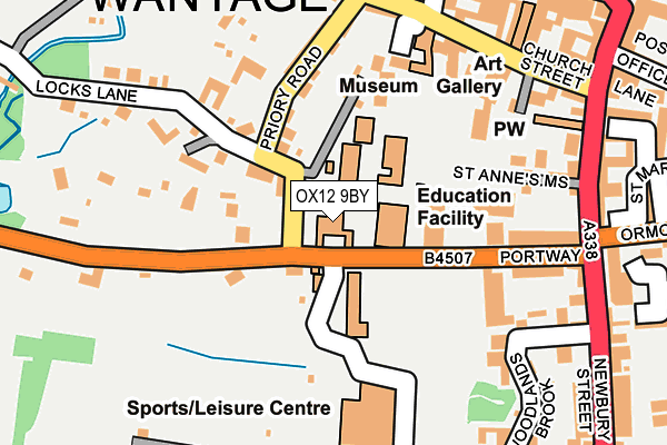
OX12 9BY is located in the Wantage Charlton electoral ward, within the local authority district of Vale of White Horse and the English Parliamentary constituency of Wantage. The Sub Integrated Care Board (ICB) Location is NHS Buckinghamshire, Oxfordshire and Berkshire West ICB - 10Q and the police force is Thames Valley. This postcode has been in use since January 1980.


GetTheData
Source: OS OpenMap – Local (Ordnance Survey)
Source: OS VectorMap District (Ordnance Survey)
Licence: Open Government Licence (requires attribution)
| Easting | 439626 |
| Northing | 187678 |
| Latitude | 51.586570 |
| Longitude | -1.429451 |
GetTheData
Source: Open Postcode Geo
Licence: Open Government Licence
| Country | England |
| Postcode District | OX12 |
➜ See where OX12 is on a map ➜ Where is Wantage? | |
GetTheData
Source: Land Registry Price Paid Data
Licence: Open Government Licence
Elevation or altitude of OX12 9BY as distance above sea level:
| Metres | Feet | |
|---|---|---|
| Elevation | 90m | 295ft |
Elevation is measured from the approximate centre of the postcode, to the nearest point on an OS contour line from OS Terrain 50, which has contour spacing of ten vertical metres.
➜ How high above sea level am I? Find the elevation of your current position using your device's GPS.
GetTheData
Source: Open Postcode Elevation
Licence: Open Government Licence
| Ward | Wantage Charlton |
| Constituency | Wantage |
GetTheData
Source: ONS Postcode Database
Licence: Open Government Licence
| King Alfreds School (Portway) | Wantage | 42m |
| Market Place | Wantage | 277m |
| Market Place | Wantage | 281m |
| Newbury Street | Wantage | 297m |
| Ham Road | Wantage | 437m |
GetTheData
Source: NaPTAN
Licence: Open Government Licence
GetTheData
Source: ONS Postcode Database
Licence: Open Government Licence


➜ Get more ratings from the Food Standards Agency
GetTheData
Source: Food Standards Agency
Licence: FSA terms & conditions
| Last Collection | |||
|---|---|---|---|
| Location | Mon-Fri | Sat | Distance |
| Wantage Sorting Office | 17:30 | 11:30 | 264m |
| Newbury Street | 17:00 | 08:15 | 295m |
| Mill Street | 17:00 | 09:00 | 398m |
GetTheData
Source: Dracos
Licence: Creative Commons Attribution-ShareAlike
The below table lists the International Territorial Level (ITL) codes (formerly Nomenclature of Territorial Units for Statistics (NUTS) codes) and Local Administrative Units (LAU) codes for OX12 9BY:
| ITL 1 Code | Name |
|---|---|
| TLJ | South East (England) |
| ITL 2 Code | Name |
| TLJ1 | Berkshire, Buckinghamshire and Oxfordshire |
| ITL 3 Code | Name |
| TLJ14 | Oxfordshire CC |
| LAU 1 Code | Name |
| E07000180 | Vale of White Horse |
GetTheData
Source: ONS Postcode Directory
Licence: Open Government Licence
The below table lists the Census Output Area (OA), Lower Layer Super Output Area (LSOA), and Middle Layer Super Output Area (MSOA) for OX12 9BY:
| Code | Name | |
|---|---|---|
| OA | E00146459 | |
| LSOA | E01028756 | Vale of White Horse 014B |
| MSOA | E02005991 | Vale of White Horse 014 |
GetTheData
Source: ONS Postcode Directory
Licence: Open Government Licence
| OX12 9DA | Priory Road | 61m |
| OX12 9BW | Portway | 92m |
| OX12 9DB | Locks Lane | 139m |
| OX12 9BU | Portway | 143m |
| OX12 9DD | Priory Road | 157m |
| OX12 9BT | Portway Mews | 157m |
| OX12 9DE | Priory Road | 159m |
| OX12 8BL | Church Street | 185m |
| OX12 8FG | St Annes Mews | 193m |
| OX12 9DF | Priory Road | 198m |
GetTheData
Source: Open Postcode Geo; Land Registry Price Paid Data
Licence: Open Government Licence