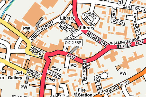
OX12 8BP is located in the Wantage Charlton electoral ward, within the local authority district of Vale of White Horse and the English Parliamentary constituency of Wantage. The Sub Integrated Care Board (ICB) Location is NHS Buckinghamshire, Oxfordshire and Berkshire West ICB - 10Q and the police force is Thames Valley. This postcode has been in use since June 2017.


GetTheData
Source: OS OpenMap – Local (Ordnance Survey)
Source: OS VectorMap District (Ordnance Survey)
Licence: Open Government Licence (requires attribution)
| Easting | 439986 |
| Northing | 187921 |
| Latitude | 51.588731 |
| Longitude | -1.424211 |
GetTheData
Source: Open Postcode Geo
Licence: Open Government Licence
| Country | England |
| Postcode District | OX12 |
➜ See where OX12 is on a map ➜ Where is Wantage? | |
GetTheData
Source: Land Registry Price Paid Data
Licence: Open Government Licence
| Ward | Wantage Charlton |
| Constituency | Wantage |
GetTheData
Source: ONS Postcode Database
Licence: Open Government Licence
| Seesen Way | Wantage | 88m |
| Seesen Way | Wantage | 99m |
| Newbury Street | Wantage | 137m |
| Market Place | Wantage | 181m |
| Market Place | Wantage | 194m |
GetTheData
Source: NaPTAN
Licence: Open Government Licence
| Percentage of properties with Next Generation Access | 100.0% |
| Percentage of properties with Superfast Broadband | 100.0% |
| Percentage of properties with Ultrafast Broadband | 0.0% |
| Percentage of properties with Full Fibre Broadband | 0.0% |
Superfast Broadband is between 30Mbps and 300Mbps
Ultrafast Broadband is > 300Mbps
| Median download speed | 24.3Mbps |
| Average download speed | 45.8Mbps |
| Maximum download speed | 79.91Mbps |
| Median upload speed | 1.3Mbps |
| Average upload speed | 8.6Mbps |
| Maximum upload speed | 20.00Mbps |
| Percentage of properties unable to receive 2Mbps | 0.0% |
| Percentage of properties unable to receive 5Mbps | 0.0% |
| Percentage of properties unable to receive 10Mbps | 0.0% |
| Percentage of properties unable to receive 30Mbps | 0.0% |
GetTheData
Source: Ofcom
Licence: Ofcom Terms of Use (requires attribution)
GetTheData
Source: ONS Postcode Database
Licence: Open Government Licence


➜ Get more ratings from the Food Standards Agency
GetTheData
Source: Food Standards Agency
Licence: FSA terms & conditions
| Last Collection | |||
|---|---|---|---|
| Location | Mon-Fri | Sat | Distance |
| Wantage Post Office | 18:30 | 11:30 | 35m |
| Wantage Sorting Office | 17:30 | 11:30 | 206m |
| Denchworth Road | 17:00 | 08:15 | 342m |
GetTheData
Source: Dracos
Licence: Creative Commons Attribution-ShareAlike
The below table lists the International Territorial Level (ITL) codes (formerly Nomenclature of Territorial Units for Statistics (NUTS) codes) and Local Administrative Units (LAU) codes for OX12 8BP:
| ITL 1 Code | Name |
|---|---|
| TLJ | South East (England) |
| ITL 2 Code | Name |
| TLJ1 | Berkshire, Buckinghamshire and Oxfordshire |
| ITL 3 Code | Name |
| TLJ14 | Oxfordshire CC |
| LAU 1 Code | Name |
| E07000180 | Vale of White Horse |
GetTheData
Source: ONS Postcode Directory
Licence: Open Government Licence
The below table lists the Census Output Area (OA), Lower Layer Super Output Area (LSOA), and Middle Layer Super Output Area (MSOA) for OX12 8BP:
| Code | Name | |
|---|---|---|
| OA | E00173204 | |
| LSOA | E01028756 | Vale of White Horse 014B |
| MSOA | E02005991 | Vale of White Horse 014 |
GetTheData
Source: ONS Postcode Directory
Licence: Open Government Licence
| OX12 8AU | Wallingford Street | 37m |
| OX12 8AX | Wallingford Street | 45m |
| OX12 8DR | Post Office Lane | 88m |
| OX12 7BB | Stirlings Road | 93m |
| OX12 8AZ | Wallingford Street | 117m |
| OX12 7AA | Grove Street | 120m |
| OX12 8BU | Newbury Street | 131m |
| OX12 8DS | Eagles Close | 131m |
| OX12 7DY | Chapel Close | 142m |
| OX12 7BX | Pickett Mews | 150m |
GetTheData
Source: Open Postcode Geo; Land Registry Price Paid Data
Licence: Open Government Licence