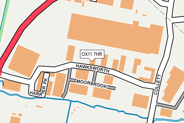
OX11 7HR is located in the Didcot North East electoral ward, within the local authority district of South Oxfordshire and the English Parliamentary constituency of Wantage. The Sub Integrated Care Board (ICB) Location is NHS Buckinghamshire, Oxfordshire and Berkshire West ICB - 10Q and the police force is Thames Valley. This postcode has been in use since January 1992.


GetTheData
Source: OS OpenMap – Local (Ordnance Survey)
Source: OS VectorMap District (Ordnance Survey)
Licence: Open Government Licence (requires attribution)
| Easting | 451933 |
| Northing | 191568 |
| Latitude | 51.620549 |
| Longitude | -1.251238 |
GetTheData
Source: Open Postcode Geo
Licence: Open Government Licence
| Country | England |
| Postcode District | OX11 |
➜ See where OX11 is on a map ➜ Where is Didcot? | |
GetTheData
Source: Land Registry Price Paid Data
Licence: Open Government Licence
Elevation or altitude of OX11 7HR as distance above sea level:
| Metres | Feet | |
|---|---|---|
| Elevation | 60m | 197ft |
Elevation is measured from the approximate centre of the postcode, to the nearest point on an OS contour line from OS Terrain 50, which has contour spacing of ten vertical metres.
➜ How high above sea level am I? Find the elevation of your current position using your device's GPS.
GetTheData
Source: Open Postcode Elevation
Licence: Open Government Licence
| Ward | Didcot North East |
| Constituency | Wantage |
GetTheData
Source: ONS Postcode Database
Licence: Open Government Licence
| Southmead Industrial Park (Hawksworth) | Didcot | 148m |
| Foxhall Manor Park (Basil Hill Road) | Didcot | 522m |
| Foxhall Manor Park (Basil Hill Road) | Didcot | 535m |
| Lyndene Road (Basil Hill Road) | Didcot | 559m |
| Lyndene Road (Basil Hill Road) | Didcot | 569m |
| Didcot Parkway Station | 1.2km |
| Appleford Station | 2.2km |
| Culham Station | 3.8km |
GetTheData
Source: NaPTAN
Licence: Open Government Licence
| Median download speed | 80.0Mbps |
| Average download speed | 67.6Mbps |
| Maximum download speed | 80.00Mbps |
| Median upload speed | 20.0Mbps |
| Average upload speed | 17.3Mbps |
| Maximum upload speed | 20.00Mbps |
GetTheData
Source: Ofcom
Licence: Ofcom Terms of Use (requires attribution)
Estimated total energy consumption in OX11 7HR by fuel type, 2015.
| Consumption (kWh) | 110,813 |
|---|---|
| Meter count | 9 |
| Mean (kWh/meter) | 12,313 |
| Median (kWh/meter) | 8,218 |
GetTheData
Source: Postcode level gas estimates: 2015 (experimental)
Source: Postcode level electricity estimates: 2015 (experimental)
Licence: Open Government Licence
GetTheData
Source: ONS Postcode Database
Licence: Open Government Licence


➜ Get more ratings from the Food Standards Agency
GetTheData
Source: Food Standards Agency
Licence: FSA terms & conditions
| Last Collection | |||
|---|---|---|---|
| Location | Mon-Fri | Sat | Distance |
| Manor Road | 17:00 | 08:30 | 1,228m |
| Tyne Avenue | 16:00 | 08:00 | 1,240m |
| Tamar Way | 17:30 | 08:00 | 1,361m |
GetTheData
Source: Dracos
Licence: Creative Commons Attribution-ShareAlike
The below table lists the International Territorial Level (ITL) codes (formerly Nomenclature of Territorial Units for Statistics (NUTS) codes) and Local Administrative Units (LAU) codes for OX11 7HR:
| ITL 1 Code | Name |
|---|---|
| TLJ | South East (England) |
| ITL 2 Code | Name |
| TLJ1 | Berkshire, Buckinghamshire and Oxfordshire |
| ITL 3 Code | Name |
| TLJ14 | Oxfordshire CC |
| LAU 1 Code | Name |
| E07000179 | South Oxfordshire |
GetTheData
Source: ONS Postcode Directory
Licence: Open Government Licence
The below table lists the Census Output Area (OA), Lower Layer Super Output Area (LSOA), and Middle Layer Super Output Area (MSOA) for OX11 7HR:
| Code | Name | |
|---|---|---|
| OA | E00145815 | |
| LSOA | E01028625 | South Oxfordshire 009A |
| MSOA | E02005966 | South Oxfordshire 009 |
GetTheData
Source: ONS Postcode Directory
Licence: Open Government Licence
| OX11 7PL | Harrier Park | 195m |
| OX11 7FG | Alphin Brook | 527m |
| OX11 7XS | Dart Drive | 531m |
| OX11 7XW | Rawthey Avenue | 544m |
| OX11 7FQ | Dudwell | 562m |
| OX11 7XJ | Old Bourne | 565m |
| OX11 7XH | Tweed Drive | 580m |
| OX11 7XD | Yealm Close | 612m |
| OX11 7FF | Sutherland Beck | 629m |
| OX11 7FE | Ouse Close | 633m |
GetTheData
Source: Open Postcode Geo; Land Registry Price Paid Data
Licence: Open Government Licence