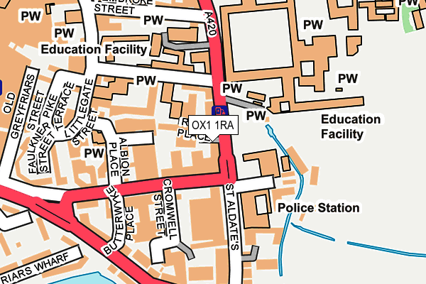
OX1 1RA lies on St Aldates in Oxford. OX1 1RA is located in the Osney & St Thomas electoral ward, within the local authority district of Oxford and the English Parliamentary constituency of Oxford East. The Sub Integrated Care Board (ICB) Location is NHS Buckinghamshire, Oxfordshire and Berkshire West ICB - 10Q and the police force is Thames Valley. This postcode has been in use since January 1980.


GetTheData
Source: OS OpenMap – Local (Ordnance Survey)
Source: OS VectorMap District (Ordnance Survey)
Licence: Open Government Licence (requires attribution)
| Easting | 451401 |
| Northing | 205857 |
| Latitude | 51.749064 |
| Longitude | -1.256822 |
GetTheData
Source: Open Postcode Geo
Licence: Open Government Licence
| Street | St Aldates |
| Town/City | Oxford |
| Country | England |
| Postcode District | OX1 |
➜ See where OX1 is on a map ➜ Where is Oxford? | |
GetTheData
Source: Land Registry Price Paid Data
Licence: Open Government Licence
Elevation or altitude of OX1 1RA as distance above sea level:
| Metres | Feet | |
|---|---|---|
| Elevation | 60m | 197ft |
Elevation is measured from the approximate centre of the postcode, to the nearest point on an OS contour line from OS Terrain 50, which has contour spacing of ten vertical metres.
➜ How high above sea level am I? Find the elevation of your current position using your device's GPS.
GetTheData
Source: Open Postcode Elevation
Licence: Open Government Licence
| Ward | Osney & St Thomas |
| Constituency | Oxford East |
GetTheData
Source: ONS Postcode Database
Licence: Open Government Licence
84, ST ALDATES, OXFORD, OX1 1RA 2000 4 SEP £395,000 |
GetTheData
Source: HM Land Registry Price Paid Data
Licence: Contains HM Land Registry data © Crown copyright and database right 2025. This data is licensed under the Open Government Licence v3.0.
| Speedwell Street | Oxford City Centre | 77m |
| Police Station (St Aldates) | Oxford City Centre | 109m |
| Speedwell Street | Oxford City Centre | 115m |
| St Aldates | Oxford City Centre | 120m |
| Police Station (St Aldates) | Oxford City Centre | 131m |
| Oxford Station | 1km |
GetTheData
Source: NaPTAN
Licence: Open Government Licence
| Percentage of properties with Next Generation Access | 83.3% |
| Percentage of properties with Superfast Broadband | 83.3% |
| Percentage of properties with Ultrafast Broadband | 50.0% |
| Percentage of properties with Full Fibre Broadband | 0.0% |
Superfast Broadband is between 30Mbps and 300Mbps
Ultrafast Broadband is > 300Mbps
| Median download speed | 62.2Mbps |
| Average download speed | 73.1Mbps |
| Maximum download speed | 200.00Mbps |
| Median upload speed | 10.5Mbps |
| Average upload speed | 10.5Mbps |
| Maximum upload speed | 20.00Mbps |
| Percentage of properties unable to receive 2Mbps | 0.0% |
| Percentage of properties unable to receive 5Mbps | 0.0% |
| Percentage of properties unable to receive 10Mbps | 0.0% |
| Percentage of properties unable to receive 30Mbps | 16.7% |
GetTheData
Source: Ofcom
Licence: Ofcom Terms of Use (requires attribution)
GetTheData
Source: ONS Postcode Database
Licence: Open Government Licence


➜ Get more ratings from the Food Standards Agency
GetTheData
Source: Food Standards Agency
Licence: FSA terms & conditions
| Last Collection | |||
|---|---|---|---|
| Location | Mon-Fri | Sat | Distance |
| St Aldates Precinct | 17:30 | 12:00 | 144m |
| Faulkner Street | 16:30 | 12:00 | 212m |
| St Aldates Post Office | 19:00 | 12:00 | 223m |
GetTheData
Source: Dracos
Licence: Creative Commons Attribution-ShareAlike
The below table lists the International Territorial Level (ITL) codes (formerly Nomenclature of Territorial Units for Statistics (NUTS) codes) and Local Administrative Units (LAU) codes for OX1 1RA:
| ITL 1 Code | Name |
|---|---|
| TLJ | South East (England) |
| ITL 2 Code | Name |
| TLJ1 | Berkshire, Buckinghamshire and Oxfordshire |
| ITL 3 Code | Name |
| TLJ14 | Oxfordshire CC |
| LAU 1 Code | Name |
| E07000178 | Oxford |
GetTheData
Source: ONS Postcode Directory
Licence: Open Government Licence
The below table lists the Census Output Area (OA), Lower Layer Super Output Area (LSOA), and Middle Layer Super Output Area (MSOA) for OX1 1RA:
| Code | Name | |
|---|---|---|
| OA | E00145308 | |
| LSOA | E01028522 | Oxford 008B |
| MSOA | E02005947 | Oxford 008 |
GetTheData
Source: ONS Postcode Directory
Licence: Open Government Licence
| OX1 1AW | Albion Place | 135m |
| OX1 1SG | Albion Place | 174m |
| OX1 1DG | St Aldates | 192m |
| OX1 1SL | Thames Street | 200m |
| OX1 1AN | Littlegate Street | 206m |
| OX1 1UA | Faulkner Street | 228m |
| OX1 1SW | Shirelake Close | 235m |
| OX1 1QL | Turn Again Lane | 240m |
| OX1 1UQ | Pike Terrace | 242m |
| OX1 1SU | Thames Street | 243m |
GetTheData
Source: Open Postcode Geo; Land Registry Price Paid Data
Licence: Open Government Licence