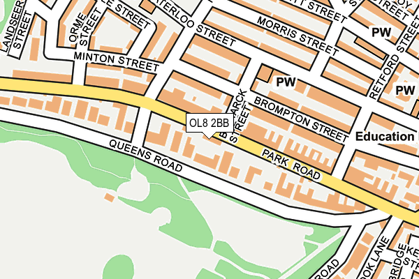
OL8 2BB is located in the Alexandra electoral ward, within the metropolitan district of Oldham and the English Parliamentary constituency of Oldham East and Saddleworth. The Sub Integrated Care Board (ICB) Location is NHS Greater Manchester ICB - 00Y and the police force is Greater Manchester. This postcode has been in use since August 1992.


GetTheData
Source: OS OpenMap – Local (Ordnance Survey)
Source: OS VectorMap District (Ordnance Survey)
Licence: Open Government Licence (requires attribution)
| Easting | 393358 |
| Northing | 404290 |
| Latitude | 53.535218 |
| Longitude | -2.101682 |
GetTheData
Source: Open Postcode Geo
Licence: Open Government Licence
| Country | England |
| Postcode District | OL8 |
➜ See where OL8 is on a map ➜ Where is Oldham? | |
GetTheData
Source: Land Registry Price Paid Data
Licence: Open Government Licence
Elevation or altitude of OL8 2BB as distance above sea level:
| Metres | Feet | |
|---|---|---|
| Elevation | 200m | 656ft |
Elevation is measured from the approximate centre of the postcode, to the nearest point on an OS contour line from OS Terrain 50, which has contour spacing of ten vertical metres.
➜ How high above sea level am I? Find the elevation of your current position using your device's GPS.
GetTheData
Source: Open Postcode Elevation
Licence: Open Government Licence
| Ward | Alexandra |
| Constituency | Oldham East And Saddleworth |
GetTheData
Source: ONS Postcode Database
Licence: Open Government Licence
| Park Rd/Woodlands (Park Rd) | Oldham | 57m |
| Park Rd/Hardy St (Park Rd) | Oldham | 122m |
| Waterloo St/Bismark St (Waterloo St) | Oldham | 135m |
| Waterloo St/Bismark St (Waterloo St) | Glodwick | 152m |
| Park Rd/Retford St (Park Rd) | Glodwick | 209m |
| Oldham Mumps (Manchester Metrolink) (Mumps) | Oldham Mumps | 806m |
| Oldham Central (Manchester Metrolink) (Union St) | Oldham | 894m |
| Oldham King Street (Manchester Metrolink) (King St) | Oldham | 1,135m |
| Mossley (Manchester) Station | 4.6km |
| Moston Station | 4.8km |
| Ashton-under-Lyne Station | 4.9km |
GetTheData
Source: NaPTAN
Licence: Open Government Licence
| Percentage of properties with Next Generation Access | 100.0% |
| Percentage of properties with Superfast Broadband | 100.0% |
| Percentage of properties with Ultrafast Broadband | 100.0% |
| Percentage of properties with Full Fibre Broadband | 0.0% |
Superfast Broadband is between 30Mbps and 300Mbps
Ultrafast Broadband is > 300Mbps
| Percentage of properties unable to receive 2Mbps | 0.0% |
| Percentage of properties unable to receive 5Mbps | 0.0% |
| Percentage of properties unable to receive 10Mbps | 0.0% |
| Percentage of properties unable to receive 30Mbps | 0.0% |
GetTheData
Source: Ofcom
Licence: Ofcom Terms of Use (requires attribution)
GetTheData
Source: ONS Postcode Database
Licence: Open Government Licence


➜ Get more ratings from the Food Standards Agency
GetTheData
Source: Food Standards Agency
Licence: FSA terms & conditions
| Last Collection | |||
|---|---|---|---|
| Location | Mon-Fri | Sat | Distance |
| 1 Chatsworth Street | 17:20 | 12:10 | 729m |
| Oldham Delivery Office | 19:00 | 734m | |
| Old Town Hall | 18:30 | 11:30 | 958m |
GetTheData
Source: Dracos
Licence: Creative Commons Attribution-ShareAlike
The below table lists the International Territorial Level (ITL) codes (formerly Nomenclature of Territorial Units for Statistics (NUTS) codes) and Local Administrative Units (LAU) codes for OL8 2BB:
| ITL 1 Code | Name |
|---|---|
| TLD | North West (England) |
| ITL 2 Code | Name |
| TLD3 | Greater Manchester |
| ITL 3 Code | Name |
| TLD37 | Greater Manchester North East |
| LAU 1 Code | Name |
| E08000004 | Oldham |
GetTheData
Source: ONS Postcode Directory
Licence: Open Government Licence
The below table lists the Census Output Area (OA), Lower Layer Super Output Area (LSOA), and Middle Layer Super Output Area (MSOA) for OL8 2BB:
| Code | Name | |
|---|---|---|
| OA | E00168617 | |
| LSOA | E01005326 | Oldham 022B |
| MSOA | E02001119 | Oldham 022 |
GetTheData
Source: ONS Postcode Directory
Licence: Open Government Licence
| OL4 1SF | Park Road | 52m |
| OL8 2BN | Alexandra Mews | 77m |
| OL4 1AB | Brompton Street | 83m |
| OL4 1AE | Bismarck Street | 88m |
| OL8 2AU | Alexandra Street | 92m |
| OL8 2BA | Queens Road | 105m |
| OL4 1AF | Brompton Street | 125m |
| OL4 1AA | Hardy Street | 138m |
| OL4 1ES | Waterloo Street | 151m |
| OL4 1SE | Grantham Street | 161m |
GetTheData
Source: Open Postcode Geo; Land Registry Price Paid Data
Licence: Open Government Licence