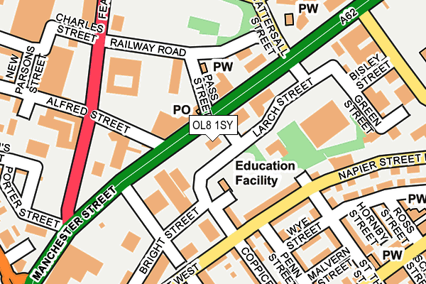
OL8 1SY is located in the Werneth electoral ward, within the metropolitan district of Oldham and the English Parliamentary constituency of Oldham West and Royton. The Sub Integrated Care Board (ICB) Location is NHS Greater Manchester ICB - 00Y and the police force is Greater Manchester. This postcode has been in use since October 1985.


GetTheData
Source: OS OpenMap – Local (Ordnance Survey)
Source: OS VectorMap District (Ordnance Survey)
Licence: Open Government Licence (requires attribution)
| Easting | 391688 |
| Northing | 404535 |
| Latitude | 53.537413 |
| Longitude | -2.126883 |
GetTheData
Source: Open Postcode Geo
Licence: Open Government Licence
| Country | England |
| Postcode District | OL8 |
➜ See where OL8 is on a map ➜ Where is Oldham? | |
GetTheData
Source: Land Registry Price Paid Data
Licence: Open Government Licence
Elevation or altitude of OL8 1SY as distance above sea level:
| Metres | Feet | |
|---|---|---|
| Elevation | 180m | 591ft |
Elevation is measured from the approximate centre of the postcode, to the nearest point on an OS contour line from OS Terrain 50, which has contour spacing of ten vertical metres.
➜ How high above sea level am I? Find the elevation of your current position using your device's GPS.
GetTheData
Source: Open Postcode Elevation
Licence: Open Government Licence
| Ward | Werneth |
| Constituency | Oldham West And Royton |
GetTheData
Source: ONS Postcode Database
Licence: Open Government Licence
| Manchester St/Alfred St (Manchester St) | Werneth | 80m |
| Manchester Steet/Alfred St (Manchester St) | Werneth | 134m |
| Napier St East/Coppice St (Napier St East) | Primrose Bank | 151m |
| Coppice St/Napier St East (Coppice St) | Primrose Bank | 192m |
| Manchester St/Lee St (Manchester St) | Werneth | 200m |
| Westwood (Manchester Metrolink) (Middleton Road) | Westwood | 550m |
| Oldham King Street (Manchester Metrolink) (King St) | Oldham | 686m |
| Freehold (Manchester Metrolink) (Block Lane) | Chadderton | 748m |
| Oldham Central (Manchester Metrolink) (Union St) | Oldham | 1,025m |
| South Chadderton (Manchester Metrolink) (Canal St) | White Gate | 1,719m |
| Moston Station | 3.3km |
| Mills Hill (Manchester) Station | 3.3km |
GetTheData
Source: NaPTAN
Licence: Open Government Licence
GetTheData
Source: ONS Postcode Database
Licence: Open Government Licence


➜ Get more ratings from the Food Standards Agency
GetTheData
Source: Food Standards Agency
Licence: FSA terms & conditions
| Last Collection | |||
|---|---|---|---|
| Location | Mon-Fri | Sat | Distance |
| Gainsborough Avenue | 17:25 | 11:55 | 600m |
| Dog Inn | 17:30 | 11:20 | 708m |
| Marland Fold | 17:05 | 11:30 | 819m |
GetTheData
Source: Dracos
Licence: Creative Commons Attribution-ShareAlike
The below table lists the International Territorial Level (ITL) codes (formerly Nomenclature of Territorial Units for Statistics (NUTS) codes) and Local Administrative Units (LAU) codes for OL8 1SY:
| ITL 1 Code | Name |
|---|---|
| TLD | North West (England) |
| ITL 2 Code | Name |
| TLD3 | Greater Manchester |
| ITL 3 Code | Name |
| TLD37 | Greater Manchester North East |
| LAU 1 Code | Name |
| E08000004 | Oldham |
GetTheData
Source: ONS Postcode Directory
Licence: Open Government Licence
The below table lists the Census Output Area (OA), Lower Layer Super Output Area (LSOA), and Middle Layer Super Output Area (MSOA) for OL8 1SY:
| Code | Name | |
|---|---|---|
| OA | E00027647 | |
| LSOA | E01032921 | Oldham 035G |
| MSOA | E02006860 | Oldham 035 |
GetTheData
Source: ONS Postcode Directory
Licence: Open Government Licence
| OL9 6HB | Manchester Street | 47m |
| OL9 6HE | Alfred Street | 98m |
| OL8 1TH | Coppice Street | 132m |
| OL8 1TS | Napier Street East | 147m |
| OL9 6HQ | Manchester Street | 167m |
| OL8 1TX | Wye Street | 176m |
| OL9 6HT | Featherstall Road South | 180m |
| OL8 4AN | Napier Street West | 196m |
| OL8 1TR | Napier Street East | 212m |
| OL8 1TY | St Thomas Street North | 217m |
GetTheData
Source: Open Postcode Geo; Land Registry Price Paid Data
Licence: Open Government Licence