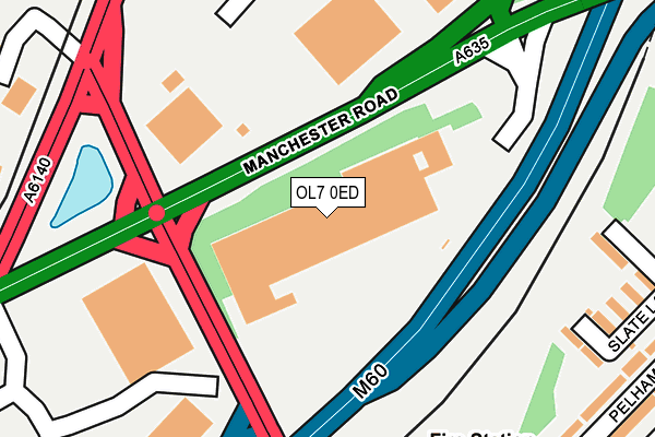
OL7 0ED is located in the Audenshaw electoral ward, within the metropolitan district of Tameside and the English Parliamentary constituency of Denton and Reddish. The Sub Integrated Care Board (ICB) Location is NHS Greater Manchester ICB - 01Y and the police force is Greater Manchester. This postcode has been in use since May 2003.


GetTheData
Source: OS OpenMap – Local (Ordnance Survey)
Source: OS VectorMap District (Ordnance Survey)
Licence: Open Government Licence (requires attribution)
| Easting | 392140 |
| Northing | 398148 |
| Latitude | 53.479995 |
| Longitude | -2.119903 |
GetTheData
Source: Open Postcode Geo
Licence: Open Government Licence
| Country | England |
| Postcode District | OL7 |
➜ See where OL7 is on a map ➜ Where is Ashton-under-Lyne? | |
GetTheData
Source: Land Registry Price Paid Data
Licence: Open Government Licence
Elevation or altitude of OL7 0ED as distance above sea level:
| Metres | Feet | |
|---|---|---|
| Elevation | 100m | 328ft |
Elevation is measured from the approximate centre of the postcode, to the nearest point on an OS contour line from OS Terrain 50, which has contour spacing of ten vertical metres.
➜ How high above sea level am I? Find the elevation of your current position using your device's GPS.
GetTheData
Source: Open Postcode Elevation
Licence: Open Government Licence
| Ward | Audenshaw |
| Constituency | Denton And Reddish |
GetTheData
Source: ONS Postcode Database
Licence: Open Government Licence
| Manchester Rd/Ashton Moss (Manchester Rd) | Ashton Moss | 94m |
| Manchester Rd/Ashton Moss (Manchester Rd) | Ashton Moss | 142m |
| Lord Sheldon Way/Garden Ctr (Lord Sheldon Wy) | Ashton Moss | 298m |
| Manchester Rd/Snipe Inn (Manchester Rd) | Ashton Moss | 426m |
| Manchester Rd/Hawthorne Gr (Manchester Rd) | Ashton Moss | 483m |
| Ashton Moss (Manchester Metrolink) (Lord Sheldon Way) | Ashton Moss | 423m |
| Audenshaw (Manchester Metrolink) (Droylesden Rd) | Audenshaw | 769m |
| Ashton West (Manchester Metrolink) (Lord Sheldon Way) | Ashton Moss | 1,323m |
| Ashton-under-lyne (Manchester Metrolink) (Wellington Rd) | Ashton Under Lyne | 1,851m |
| Guide Bridge Station | 0.7km |
| Fairfield Station | 2km |
| Ashton-under-Lyne Station | 2.1km |
GetTheData
Source: NaPTAN
Licence: Open Government Licence
GetTheData
Source: ONS Postcode Database
Licence: Open Government Licence


➜ Get more ratings from the Food Standards Agency
GetTheData
Source: Food Standards Agency
Licence: FSA terms & conditions
| Last Collection | |||
|---|---|---|---|
| Location | Mon-Fri | Sat | Distance |
| Junction P.o. | 17:30 | 12:00 | 588m |
| 2 Acresfield Avenue | 17:30 | 12:00 | 1,064m |
| Stamford Road | 17:30 | 12:00 | 1,252m |
GetTheData
Source: Dracos
Licence: Creative Commons Attribution-ShareAlike
The below table lists the International Territorial Level (ITL) codes (formerly Nomenclature of Territorial Units for Statistics (NUTS) codes) and Local Administrative Units (LAU) codes for OL7 0ED:
| ITL 1 Code | Name |
|---|---|
| TLD | North West (England) |
| ITL 2 Code | Name |
| TLD3 | Greater Manchester |
| ITL 3 Code | Name |
| TLD35 | Greater Manchester South East |
| LAU 1 Code | Name |
| E08000008 | Tameside |
GetTheData
Source: ONS Postcode Directory
Licence: Open Government Licence
The below table lists the Census Output Area (OA), Lower Layer Super Output Area (LSOA), and Middle Layer Super Output Area (MSOA) for OL7 0ED:
| Code | Name | |
|---|---|---|
| OA | E00030137 | |
| LSOA | E01005951 | Tameside 013C |
| MSOA | E02001241 | Tameside 013 |
GetTheData
Source: ONS Postcode Directory
Licence: Open Government Licence
| OL7 0DX | Durban Street | 262m |
| OL7 0DZ | Birch Street | 272m |
| OL7 0DY | Gartside Street | 277m |
| OL7 0DT | Pelham Street | 318m |
| OL7 0DU | Pelham Street | 326m |
| OL7 0DW | Sharon Close | 348m |
| M34 5RQ | Milton Road | 359m |
| OL7 0DS | Pelham Street | 378m |
| OL7 0HP | Mansfield Street | 380m |
| OL7 0HT | Marlborough Close | 382m |
GetTheData
Source: Open Postcode Geo; Land Registry Price Paid Data
Licence: Open Government Licence