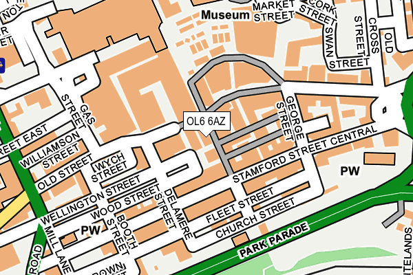
OL6 6AZ lies on Warrington Street in Ashton-under-lyne. OL6 6AZ is located in the St Peter's electoral ward, within the metropolitan district of Tameside and the English Parliamentary constituency of Ashton-under-Lyne. The Sub Integrated Care Board (ICB) Location is NHS Greater Manchester ICB - 01Y and the police force is Greater Manchester. This postcode has been in use since January 1980.


GetTheData
Source: OS OpenMap – Local (Ordnance Survey)
Source: OS VectorMap District (Ordnance Survey)
Licence: Open Government Licence (requires attribution)
| Easting | 393890 |
| Northing | 399027 |
| Latitude | 53.487919 |
| Longitude | -2.093551 |
GetTheData
Source: Open Postcode Geo
Licence: Open Government Licence
| Street | Warrington Street |
| Town/City | Ashton-under-lyne |
| Country | England |
| Postcode District | OL6 |
➜ See where OL6 is on a map ➜ Where is Ashton-under-Lyne? | |
GetTheData
Source: Land Registry Price Paid Data
Licence: Open Government Licence
Elevation or altitude of OL6 6AZ as distance above sea level:
| Metres | Feet | |
|---|---|---|
| Elevation | 110m | 361ft |
Elevation is measured from the approximate centre of the postcode, to the nearest point on an OS contour line from OS Terrain 50, which has contour spacing of ten vertical metres.
➜ How high above sea level am I? Find the elevation of your current position using your device's GPS.
GetTheData
Source: Open Postcode Elevation
Licence: Open Government Licence
| Ward | St Peter's |
| Constituency | Ashton-under-lyne |
GetTheData
Source: ONS Postcode Database
Licence: Open Government Licence
| Stamford St/Delamere St (Stamford St) | Ashton Under Lyne | 85m |
| Stamford St/Old Square (Stamford St) | Ashton Under Lyne | 195m |
| Wellington Rd/Market Hall (Wellington Rd) | Ashton Under Lyne | 221m |
| Wellington Rd/Market Hall (Wellington Rd) | Ashton Under Lyne | 232m |
| Wellington Rd/Market Hall (Wellington Rd) | Ashton Under Lyne | 239m |
| Ashton-under-lyne (Manchester Metrolink) (Wellington Rd) | Ashton Under Lyne | 400m |
| Ashton West (Manchester Metrolink) (Lord Sheldon Way) | Ashton Moss | 1,104m |
| Ashton-under-Lyne Station | 0.4km |
| Guide Bridge Station | 2km |
| Stalybridge Station | 2.1km |
GetTheData
Source: NaPTAN
Licence: Open Government Licence
GetTheData
Source: ONS Postcode Database
Licence: Open Government Licence


➜ Get more ratings from the Food Standards Agency
GetTheData
Source: Food Standards Agency
Licence: FSA terms & conditions
| Last Collection | |||
|---|---|---|---|
| Location | Mon-Fri | Sat | Distance |
| Ashton Delivery Office | 19:00 | 396m | |
| Grafton Street | 17:30 | 11:25 | 688m |
| Christchurch | 17:25 | 11:50 | 803m |
GetTheData
Source: Dracos
Licence: Creative Commons Attribution-ShareAlike
The below table lists the International Territorial Level (ITL) codes (formerly Nomenclature of Territorial Units for Statistics (NUTS) codes) and Local Administrative Units (LAU) codes for OL6 6AZ:
| ITL 1 Code | Name |
|---|---|
| TLD | North West (England) |
| ITL 2 Code | Name |
| TLD3 | Greater Manchester |
| ITL 3 Code | Name |
| TLD35 | Greater Manchester South East |
| LAU 1 Code | Name |
| E08000008 | Tameside |
GetTheData
Source: ONS Postcode Directory
Licence: Open Government Licence
The below table lists the Census Output Area (OA), Lower Layer Super Output Area (LSOA), and Middle Layer Super Output Area (MSOA) for OL6 6AZ:
| Code | Name | |
|---|---|---|
| OA | E00030150 | |
| LSOA | E01005948 | Tameside 013A |
| MSOA | E02001241 | Tameside 013 |
GetTheData
Source: ONS Postcode Directory
Licence: Open Government Licence
| OL6 6AS | Warrington Street | 32m |
| OL6 6BG | Wellington Street | 53m |
| OL6 6AT | Wood Street | 56m |
| OL6 6AB | Stamford Street Central | 64m |
| OL6 6AL | Market Avenue | 67m |
| OL6 7LR | Stamford Street Central | 68m |
| OL6 6AR | Market Avenue | 73m |
| OL6 6XW | Stamford Street Central | 92m |
| OL6 6BT | Market Avenue | 100m |
| OL6 6XB | Warrington Street | 103m |
GetTheData
Source: Open Postcode Geo; Land Registry Price Paid Data
Licence: Open Government Licence