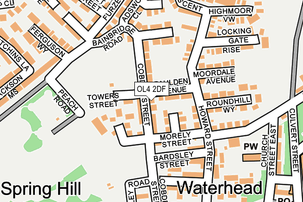
OL4 2DF lies on Cobden Street in Oldham. OL4 2DF is located in the Waterhead electoral ward, within the metropolitan district of Oldham and the English Parliamentary constituency of Oldham East and Saddleworth. The Sub Integrated Care Board (ICB) Location is NHS Greater Manchester ICB - 00Y and the police force is Greater Manchester. This postcode has been in use since June 2001.


GetTheData
Source: OS OpenMap – Local (Ordnance Survey)
Source: OS VectorMap District (Ordnance Survey)
Licence: Open Government Licence (requires attribution)
| Easting | 395006 |
| Northing | 405896 |
| Latitude | 53.549689 |
| Longitude | -2.076842 |
GetTheData
Source: Open Postcode Geo
Licence: Open Government Licence
| Street | Cobden Street |
| Town/City | Oldham |
| Country | England |
| Postcode District | OL4 |
➜ See where OL4 is on a map ➜ Where is Oldham? | |
GetTheData
Source: Land Registry Price Paid Data
Licence: Open Government Licence
Elevation or altitude of OL4 2DF as distance above sea level:
| Metres | Feet | |
|---|---|---|
| Elevation | 230m | 755ft |
Elevation is measured from the approximate centre of the postcode, to the nearest point on an OS contour line from OS Terrain 50, which has contour spacing of ten vertical metres.
➜ How high above sea level am I? Find the elevation of your current position using your device's GPS.
GetTheData
Source: Open Postcode Elevation
Licence: Open Government Licence
| Ward | Waterhead |
| Constituency | Oldham East And Saddleworth |
GetTheData
Source: ONS Postcode Database
Licence: Open Government Licence
| Cobden Street (Northbound) (Cobden Street) | Waterhead | 14m |
| Cobden St/Moss St (Cobden St) | Waterhead | 36m |
| Huddersfield Rd/Cobden St (Huddersfield Rd) | Waterhead | 49m |
| Huddersfield Rd/Heywood St (Huddersfield Rd) | Waterhead | 62m |
| Cobden Street (Southbound) (Cobden Street) | Waterhead | 86m |
| Greenfield Station | 4.3km |
| Mossley (Manchester) Station | 4.5km |
GetTheData
Source: NaPTAN
Licence: Open Government Licence
GetTheData
Source: ONS Postcode Database
Licence: Open Government Licence


➜ Get more ratings from the Food Standards Agency
GetTheData
Source: Food Standards Agency
Licence: FSA terms & conditions
| Last Collection | |||
|---|---|---|---|
| Location | Mon-Fri | Sat | Distance |
| Burnley Street | 17:45 | 11:10 | 787m |
| 50 Spring Street | 17:40 | 12:15 | 789m |
| John Street | 16:45 | 11:20 | 822m |
GetTheData
Source: Dracos
Licence: Creative Commons Attribution-ShareAlike
The below table lists the International Territorial Level (ITL) codes (formerly Nomenclature of Territorial Units for Statistics (NUTS) codes) and Local Administrative Units (LAU) codes for OL4 2DF:
| ITL 1 Code | Name |
|---|---|
| TLD | North West (England) |
| ITL 2 Code | Name |
| TLD3 | Greater Manchester |
| ITL 3 Code | Name |
| TLD37 | Greater Manchester North East |
| LAU 1 Code | Name |
| E08000004 | Oldham |
GetTheData
Source: ONS Postcode Directory
Licence: Open Government Licence
The below table lists the Census Output Area (OA), Lower Layer Super Output Area (LSOA), and Middle Layer Super Output Area (MSOA) for OL4 2DF:
| Code | Name | |
|---|---|---|
| OA | E00168623 | |
| LSOA | E01005449 | Oldham 012B |
| MSOA | E02001109 | Oldham 012 |
GetTheData
Source: ONS Postcode Directory
Licence: Open Government Licence
| OL4 2HT | Huddersfield Road | 24m |
| OL4 2SS | Violet Hill Court | 56m |
| OL4 2HP | Ann Square | 106m |
| OL4 2HB | Brideoak Street | 134m |
| OL4 2JD | Morley Street | 135m |
| OL4 2HH | Stephenson Street | 146m |
| OL4 2JE | Bardsley Street | 147m |
| OL4 2HX | Peach Road | 152m |
| OL4 2UY | Watergate Milne Court | 156m |
| OL4 2HR | Rose Hill Court | 162m |
GetTheData
Source: Open Postcode Geo; Land Registry Price Paid Data
Licence: Open Government Licence