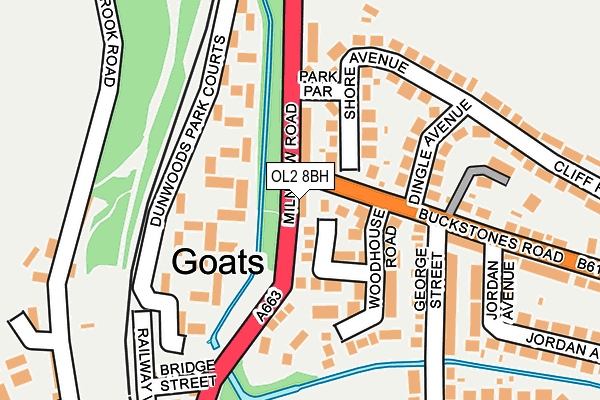
OL2 8BH lies on Goats in Shaw, Oldham. OL2 8BH is located in the Shaw electoral ward, within the metropolitan district of Oldham and the English Parliamentary constituency of Oldham East and Saddleworth. The Sub Integrated Care Board (ICB) Location is NHS Greater Manchester ICB - 00Y and the police force is Greater Manchester. This postcode has been in use since January 1980.


GetTheData
Source: OS OpenMap – Local (Ordnance Survey)
Source: OS VectorMap District (Ordnance Survey)
Licence: Open Government Licence (requires attribution)
| Easting | 394287 |
| Northing | 410129 |
| Latitude | 53.587729 |
| Longitude | -2.087773 |
GetTheData
Source: Open Postcode Geo
Licence: Open Government Licence
| Street | Goats |
| Locality | Shaw |
| Town/City | Oldham |
| Country | England |
| Postcode District | OL2 |
➜ See where OL2 is on a map ➜ Where is Shaw? | |
GetTheData
Source: Land Registry Price Paid Data
Licence: Open Government Licence
Elevation or altitude of OL2 8BH as distance above sea level:
| Metres | Feet | |
|---|---|---|
| Elevation | 170m | 558ft |
Elevation is measured from the approximate centre of the postcode, to the nearest point on an OS contour line from OS Terrain 50, which has contour spacing of ten vertical metres.
➜ How high above sea level am I? Find the elevation of your current position using your device's GPS.
GetTheData
Source: Open Postcode Elevation
Licence: Open Government Licence
| Ward | Shaw |
| Constituency | Oldham East And Saddleworth |
GetTheData
Source: ONS Postcode Database
Licence: Open Government Licence
| Milnrow Rd/Buckstones Rd (Milnrow Rd) | Shaw | 42m |
| Milnrow Rd/Buckstones Rd (Milnrow Rd) | Shaw | 45m |
| Buckstones Rd/George St (Buckstones Rd) | Buckstones Estate | 100m |
| Buckstones Rd/George St (Buckstones Rd) | Buckstones Estate | 169m |
| Milnrow Rd/Bridge St (Milnrow Rd) | Shaw | 246m |
| Shaw And Crompton (Manchester Metrolink) (Beal Lane) | Shaw | 1,292m |
| Newhey (Manchester Metrolink) (Huddersfield Road) | Newhey | 1,535m |
| Rochdale Station | 5km |
GetTheData
Source: NaPTAN
Licence: Open Government Licence
| Median download speed | 90.0Mbps |
| Average download speed | 100.6Mbps |
| Maximum download speed | 350.00Mbps |
| Median upload speed | 1.0Mbps |
| Average upload speed | 7.3Mbps |
| Maximum upload speed | 20.00Mbps |
GetTheData
Source: Ofcom
Licence: Ofcom Terms of Use (requires attribution)
Estimated total energy consumption in OL2 8BH by fuel type, 2015.
| Consumption (kWh) | 76,471 |
|---|---|
| Meter count | 7 |
| Mean (kWh/meter) | 10,924 |
| Median (kWh/meter) | 9,891 |
| Consumption (kWh) | 36,650 |
|---|---|
| Meter count | 9 |
| Mean (kWh/meter) | 4,072 |
| Median (kWh/meter) | 3,577 |
GetTheData
Source: Postcode level gas estimates: 2015 (experimental)
Source: Postcode level electricity estimates: 2015 (experimental)
Licence: Open Government Licence
GetTheData
Source: ONS Postcode Database
Licence: Open Government Licence


➜ Get more ratings from the Food Standards Agency
GetTheData
Source: Food Standards Agency
Licence: FSA terms & conditions
| Last Collection | |||
|---|---|---|---|
| Location | Mon-Fri | Sat | Distance |
| Dunwood Park Court | 17:25 | 11:50 | 503m |
| Wrens Nest | 17:15 | 11:45 | 608m |
| Lower Rushcroft P.o. | 17:30 | 11:35 | 921m |
GetTheData
Source: Dracos
Licence: Creative Commons Attribution-ShareAlike
| Risk of OL2 8BH flooding from rivers and sea | High |
| ➜ OL2 8BH flood map | |
GetTheData
Source: Open Flood Risk by Postcode
Licence: Open Government Licence
The below table lists the International Territorial Level (ITL) codes (formerly Nomenclature of Territorial Units for Statistics (NUTS) codes) and Local Administrative Units (LAU) codes for OL2 8BH:
| ITL 1 Code | Name |
|---|---|
| TLD | North West (England) |
| ITL 2 Code | Name |
| TLD3 | Greater Manchester |
| ITL 3 Code | Name |
| TLD37 | Greater Manchester North East |
| LAU 1 Code | Name |
| E08000004 | Oldham |
GetTheData
Source: ONS Postcode Directory
Licence: Open Government Licence
The below table lists the Census Output Area (OA), Lower Layer Super Output Area (LSOA), and Middle Layer Super Output Area (MSOA) for OL2 8BH:
| Code | Name | |
|---|---|---|
| OA | E00027556 | |
| LSOA | E01005441 | Oldham 002A |
| MSOA | E02001099 | Oldham 002 |
GetTheData
Source: ONS Postcode Directory
Licence: Open Government Licence
| OL2 8GB | Crossfield Close | 67m |
| OL2 8GA | Woodhouse Road | 117m |
| OL2 8ED | Dunwood Park Courts | 118m |
| OL2 8DA | Shore Avenue | 121m |
| OL2 8BL | Milnrow Road | 126m |
| OL2 8BJ | Milnrow Road | 127m |
| OL2 8GD | Compton Fold | 142m |
| OL2 8DD | Dingle Avenue | 149m |
| OL2 8DS | George Street | 191m |
| OL2 8BQ | Railway View | 211m |
GetTheData
Source: Open Postcode Geo; Land Registry Price Paid Data
Licence: Open Government Licence