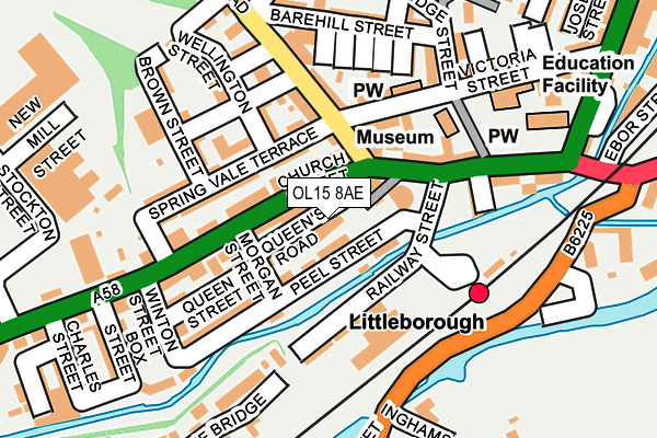
OL15 8AE is located in the Littleborough Lakeside electoral ward, within the metropolitan district of Rochdale and the English Parliamentary constituency of Rochdale. The Sub Integrated Care Board (ICB) Location is NHS Greater Manchester ICB - 01D and the police force is Greater Manchester. This postcode has been in use since January 1980.


GetTheData
Source: OS OpenMap – Local (Ordnance Survey)
Source: OS VectorMap District (Ordnance Survey)
Licence: Open Government Licence (requires attribution)
| Easting | 393690 |
| Northing | 416328 |
| Latitude | 53.643423 |
| Longitude | -2.096921 |
GetTheData
Source: Open Postcode Geo
Licence: Open Government Licence
| Country | England |
| Postcode District | OL15 |
➜ See where OL15 is on a map ➜ Where is Littleborough? | |
GetTheData
Source: Land Registry Price Paid Data
Licence: Open Government Licence
Elevation or altitude of OL15 8AE as distance above sea level:
| Metres | Feet | |
|---|---|---|
| Elevation | 150m | 492ft |
Elevation is measured from the approximate centre of the postcode, to the nearest point on an OS contour line from OS Terrain 50, which has contour spacing of ten vertical metres.
➜ How high above sea level am I? Find the elevation of your current position using your device's GPS.
GetTheData
Source: Open Postcode Elevation
Licence: Open Government Licence
| Ward | Littleborough Lakeside |
| Constituency | Rochdale |
GetTheData
Source: ONS Postcode Database
Licence: Open Government Licence
| Church St/Littleborough Square (Church Street) | Littleborough | 46m |
| Church St/Littleborough Square (Church Street) | Littleborough | 76m |
| Railway St/Church St (Railway St) | Littleborough | 98m |
| Station Rd/Littleborough Stn (Station Rd) | Littleborough | 135m |
| Hare Hill Rd/Greenwood St (Hare Hill Rd) | Littleborough | 152m |
| Littleborough Station | 0.2km |
| Smithy Bridge Station | 1.6km |
| Rochdale Station | 5.3km |
GetTheData
Source: NaPTAN
Licence: Open Government Licence
GetTheData
Source: ONS Postcode Database
Licence: Open Government Licence


➜ Get more ratings from the Food Standards Agency
GetTheData
Source: Food Standards Agency
Licence: FSA terms & conditions
| Last Collection | |||
|---|---|---|---|
| Location | Mon-Fri | Sat | Distance |
| 109 Church Street | 17:30 | 11:00 | 184m |
| 17 Todmorden Road | 17:15 | 11:00 | 314m |
| Caldermoor P.o. | 17:00 | 11:30 | 594m |
GetTheData
Source: Dracos
Licence: Creative Commons Attribution-ShareAlike
The below table lists the International Territorial Level (ITL) codes (formerly Nomenclature of Territorial Units for Statistics (NUTS) codes) and Local Administrative Units (LAU) codes for OL15 8AE:
| ITL 1 Code | Name |
|---|---|
| TLD | North West (England) |
| ITL 2 Code | Name |
| TLD3 | Greater Manchester |
| ITL 3 Code | Name |
| TLD37 | Greater Manchester North East |
| LAU 1 Code | Name |
| E08000005 | Rochdale |
GetTheData
Source: ONS Postcode Directory
Licence: Open Government Licence
The below table lists the Census Output Area (OA), Lower Layer Super Output Area (LSOA), and Middle Layer Super Output Area (MSOA) for OL15 8AE:
| Code | Name | |
|---|---|---|
| OA | E00027933 | |
| LSOA | E01005522 | Rochdale 001C |
| MSOA | E02001132 | Rochdale 001 |
GetTheData
Source: ONS Postcode Directory
Licence: Open Government Licence
| OL15 8AB | Church Street | 21m |
| OL15 8AN | Queens Road Terrace | 40m |
| OL15 8BL | Eastwood Street | 56m |
| OL15 8AU | Church Street | 65m |
| OL15 8BJ | Victoria Street | 67m |
| OL15 8AJ | Morgan Street | 86m |
| OL15 9AB | Hare Hill Road | 86m |
| OL15 8AP | Spring Gardens | 88m |
| OL15 8AQ | Peel Street | 103m |
| OL15 9AA | Church Street | 103m |
GetTheData
Source: Open Postcode Geo; Land Registry Price Paid Data
Licence: Open Government Licence