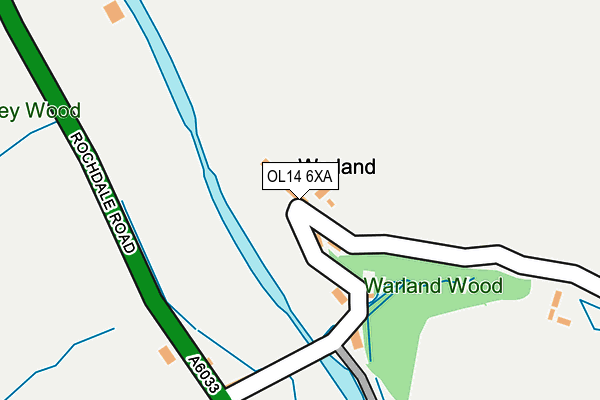
OL14 6XA lies on Warland in Todmorden. OL14 6XA is located in the Todmorden electoral ward, within the metropolitan district of Calderdale and the English Parliamentary constituency of Calder Valley. The Sub Integrated Care Board (ICB) Location is NHS West Yorkshire ICB - 02T and the police force is West Yorkshire. This postcode has been in use since January 1980.


GetTheData
Source: OS OpenMap – Local (Ordnance Survey)
Source: OS VectorMap District (Ordnance Survey)
Licence: Open Government Licence (requires attribution)
| Easting | 394553 |
| Northing | 420289 |
| Latitude | 53.679035 |
| Longitude | -2.083938 |
GetTheData
Source: Open Postcode Geo
Licence: Open Government Licence
| Street | Warland |
| Town/City | Todmorden |
| Country | England |
| Postcode District | OL14 |
➜ See where OL14 is on a map ➜ Where is Warland? | |
GetTheData
Source: Land Registry Price Paid Data
Licence: Open Government Licence
Elevation or altitude of OL14 6XA as distance above sea level:
| Metres | Feet | |
|---|---|---|
| Elevation | 200m | 656ft |
Elevation is measured from the approximate centre of the postcode, to the nearest point on an OS contour line from OS Terrain 50, which has contour spacing of ten vertical metres.
➜ How high above sea level am I? Find the elevation of your current position using your device's GPS.
GetTheData
Source: Open Postcode Elevation
Licence: Open Government Licence
| Ward | Todmorden |
| Constituency | Calder Valley |
GetTheData
Source: ONS Postcode Database
Licence: Open Government Licence
| Rochdale Road Bird I'th Hand Ph (Rochdale Road) | Walsden | 188m |
| Rochdale Road Bird I'th Hand Ph (Rochdale Road) | Walsden | 217m |
| Todmorden Rd Calderbrook Road (Todmorden Road) | Walsden | 445m |
| Todmorden Rd Calderbrook Road (Rochdale Road) | Walsden | 448m |
| Rochdale Rd Stone House Bridge (Rochdale Road) | Walsden | 552m |
| Walsden Station | 2.3km |
| Todmorden Station | 4km |
| Littleborough Station | 4.1km |
GetTheData
Source: NaPTAN
Licence: Open Government Licence
| Percentage of properties with Next Generation Access | 100.0% |
| Percentage of properties with Superfast Broadband | 0.0% |
| Percentage of properties with Ultrafast Broadband | 0.0% |
| Percentage of properties with Full Fibre Broadband | 0.0% |
Superfast Broadband is between 30Mbps and 300Mbps
Ultrafast Broadband is > 300Mbps
| Percentage of properties unable to receive 2Mbps | 0.0% |
| Percentage of properties unable to receive 5Mbps | 100.0% |
| Percentage of properties unable to receive 10Mbps | 100.0% |
| Percentage of properties unable to receive 30Mbps | 100.0% |
GetTheData
Source: Ofcom
Licence: Ofcom Terms of Use (requires attribution)
GetTheData
Source: ONS Postcode Database
Licence: Open Government Licence


➜ Get more ratings from the Food Standards Agency
GetTheData
Source: Food Standards Agency
Licence: FSA terms & conditions
| Last Collection | |||
|---|---|---|---|
| Location | Mon-Fri | Sat | Distance |
| 6 Deanhead | 17:15 | 11:00 | 1,186m |
| Walsden P.o. | 17:15 | 11:30 | 1,981m |
| Walsden Station | 17:15 | 11:30 | 2,364m |
GetTheData
Source: Dracos
Licence: Creative Commons Attribution-ShareAlike
The below table lists the International Territorial Level (ITL) codes (formerly Nomenclature of Territorial Units for Statistics (NUTS) codes) and Local Administrative Units (LAU) codes for OL14 6XA:
| ITL 1 Code | Name |
|---|---|
| TLE | Yorkshire and The Humber |
| ITL 2 Code | Name |
| TLE4 | West Yorkshire |
| ITL 3 Code | Name |
| TLE44 | Calderdale and Kirklees |
| LAU 1 Code | Name |
| E08000033 | Calderdale |
GetTheData
Source: ONS Postcode Directory
Licence: Open Government Licence
The below table lists the Census Output Area (OA), Lower Layer Super Output Area (LSOA), and Middle Layer Super Output Area (MSOA) for OL14 6XA:
| Code | Name | |
|---|---|---|
| OA | E00054869 | |
| LSOA | E01010886 | Calderdale 022C |
| MSOA | E02002265 | Calderdale 022 |
GetTheData
Source: ONS Postcode Directory
Licence: Open Government Licence
| OL14 6UZ | Claremont Terrace | 42m |
| OL14 6UY | Woodbank | 147m |
| OL14 6UP | Warland Gate End | 185m |
| OL14 6XB | Warland | 388m |
| OL14 6UR | Warland | 412m |
| OL15 9PE | Todmorden Road | 455m |
| OL14 7UT | Top O Th Close Road | 689m |
| OL14 6UQ | Bottomley Road | 717m |
| OL14 6TY | Rochdale Road | 804m |
| OL14 6TZ | Chapel Close | 847m |
GetTheData
Source: Open Postcode Geo; Land Registry Price Paid Data
Licence: Open Government Licence