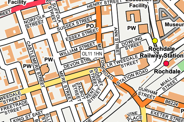
OL11 1HN is located in the Milkstone & Deeplish electoral ward, within the metropolitan district of Rochdale and the English Parliamentary constituency of Rochdale. The Sub Integrated Care Board (ICB) Location is NHS Greater Manchester ICB - 01D and the police force is Greater Manchester. This postcode has been in use since May 1994.


GetTheData
Source: OS OpenMap – Local (Ordnance Survey)
Source: OS VectorMap District (Ordnance Survey)
Licence: Open Government Licence (requires attribution)
| Easting | 389680 |
| Northing | 412651 |
| Latitude | 53.610309 |
| Longitude | -2.157454 |
GetTheData
Source: Open Postcode Geo
Licence: Open Government Licence
| Country | England |
| Postcode District | OL11 |
➜ See where OL11 is on a map ➜ Where is Rochdale? | |
GetTheData
Source: Land Registry Price Paid Data
Licence: Open Government Licence
Elevation or altitude of OL11 1HN as distance above sea level:
| Metres | Feet | |
|---|---|---|
| Elevation | 140m | 459ft |
Elevation is measured from the approximate centre of the postcode, to the nearest point on an OS contour line from OS Terrain 50, which has contour spacing of ten vertical metres.
➜ How high above sea level am I? Find the elevation of your current position using your device's GPS.
GetTheData
Source: Open Postcode Elevation
Licence: Open Government Licence
| Ward | Milkstone & Deeplish |
| Constituency | Rochdale |
GetTheData
Source: ONS Postcode Database
Licence: Open Government Licence
| Tweedale St/Mere St (Tweedale St) | Rochdale | 88m |
| Rochdale Railway Stn (Station Road) | Rochdale | 197m |
| Rochdale Railway Stn (Station Rd) | Rochdale | 210m |
| Milkstone Rd/Exeter St (Milkstone Rd) | Rochdale | 220m |
| Drake St/Milkstone Rd (Drake St) | Rochdale | 222m |
| Rochdale Railway Station (Manchester Metrolink) (Maclure Rd) | Rochdale | 213m |
| Rochdale Interchange (Manchester Metrolink) (Smith Street) | Rochdale | 792m |
| Newbold (Manchester Metrolink) (Kingsway) | Newbold | 1,491m |
| Rochdale Station | 0.3km |
| Castleton (Manchester) Station | 2.5km |
| Smithy Bridge Station | 3.9km |
GetTheData
Source: NaPTAN
Licence: Open Government Licence
GetTheData
Source: ONS Postcode Database
Licence: Open Government Licence


➜ Get more ratings from the Food Standards Agency
GetTheData
Source: Food Standards Agency
Licence: FSA terms & conditions
| Last Collection | |||
|---|---|---|---|
| Location | Mon-Fri | Sat | Distance |
| 13a Milnrow Road | 17:30 | 11:00 | 265m |
| 2 Merefield Street | 17:30 | 11:00 | 494m |
| Wet Rake | 18:30 | 11:00 | 523m |
GetTheData
Source: Dracos
Licence: Creative Commons Attribution-ShareAlike
The below table lists the International Territorial Level (ITL) codes (formerly Nomenclature of Territorial Units for Statistics (NUTS) codes) and Local Administrative Units (LAU) codes for OL11 1HN:
| ITL 1 Code | Name |
|---|---|
| TLD | North West (England) |
| ITL 2 Code | Name |
| TLD3 | Greater Manchester |
| ITL 3 Code | Name |
| TLD37 | Greater Manchester North East |
| LAU 1 Code | Name |
| E08000005 | Rochdale |
GetTheData
Source: ONS Postcode Directory
Licence: Open Government Licence
The below table lists the Census Output Area (OA), Lower Layer Super Output Area (LSOA), and Middle Layer Super Output Area (MSOA) for OL11 1HN:
| Code | Name | |
|---|---|---|
| OA | E00027756 | |
| LSOA | E01005485 | Rochdale 015D |
| MSOA | E02001146 | Rochdale 015 |
GetTheData
Source: ONS Postcode Directory
Licence: Open Government Licence
| OL11 1EB | Milkstone Road | 48m |
| OL11 1HH | Tweedale Street | 64m |
| OL11 1HW | William Street | 77m |
| OL11 1EZ | Ann Street | 78m |
| OL11 1HG | Lower Tweedale Street | 95m |
| OL11 3SZ | Monmouth Street | 98m |
| OL11 3SL | Kent Street | 103m |
| OL11 1EJ | Essex Street | 104m |
| OL11 3SY | Talbot Street | 113m |
| OL11 3TA | Milkstone Place | 116m |
GetTheData
Source: Open Postcode Geo; Land Registry Price Paid Data
Licence: Open Government Licence