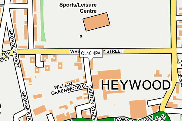
OL10 4PA is located in the North Heywood electoral ward, within the metropolitan district of Rochdale and the English Parliamentary constituency of Heywood and Middleton. The Sub Integrated Care Board (ICB) Location is NHS Greater Manchester ICB - 01D and the police force is Greater Manchester. This postcode has been in use since June 2017.


GetTheData
Source: OS OpenMap – Local (Ordnance Survey)
Source: OS VectorMap District (Ordnance Survey)
Licence: Open Government Licence (requires attribution)
| Easting | 385601 |
| Northing | 410812 |
| Latitude | 53.593699 |
| Longitude | -2.219017 |
GetTheData
Source: Open Postcode Geo
Licence: Open Government Licence
| Country | England |
| Postcode District | OL10 |
➜ See where OL10 is on a map ➜ Where is Heywood? | |
GetTheData
Source: Land Registry Price Paid Data
Licence: Open Government Licence
| Ward | North Heywood |
| Constituency | Heywood And Middleton |
GetTheData
Source: ONS Postcode Database
Licence: Open Government Licence
| L/Cpl Shaw Mc Way/Heywood Library (L/Cpl Shaw Mc) | Heywood | 73m |
| L/Cpl Shaw Mc Way/Heywood Library (L/Cpl Shaw Mc) | Heywood | 74m |
| L/Cpl Shaw Mc Way/Heywood Library (L/Cpl Shaw Mc) | Heywood | 89m |
| L/Cpl Shaw Mc Way/Heywood Library (L/Cpl Shaw Mc) | Heywood | 106m |
| Queens Park Rd (N Bnd) (Queens Park Rd) | Heywood | 110m |
| Heywood (East Lancashire Railway) | Heywood | 946m |
| Castleton (Manchester) Station | 2.7km |
| Rochdale Station | 4.7km |
| Mills Hill (Manchester) Station | 5.7km |
GetTheData
Source: NaPTAN
Licence: Open Government Licence
| Percentage of properties with Next Generation Access | 100.0% |
| Percentage of properties with Superfast Broadband | 100.0% |
| Percentage of properties with Ultrafast Broadband | 66.7% |
| Percentage of properties with Full Fibre Broadband | 0.0% |
Superfast Broadband is between 30Mbps and 300Mbps
Ultrafast Broadband is > 300Mbps
| Percentage of properties unable to receive 2Mbps | 0.0% |
| Percentage of properties unable to receive 5Mbps | 0.0% |
| Percentage of properties unable to receive 10Mbps | 0.0% |
| Percentage of properties unable to receive 30Mbps | 0.0% |
GetTheData
Source: Ofcom
Licence: Ofcom Terms of Use (requires attribution)
GetTheData
Source: ONS Postcode Database
Licence: Open Government Licence


➜ Get more ratings from the Food Standards Agency
GetTheData
Source: Food Standards Agency
Licence: FSA terms & conditions
| Last Collection | |||
|---|---|---|---|
| Location | Mon-Fri | Sat | Distance |
| Heywood Post Office | 139m | ||
| Morrison's | 17:45 | 11:30 | 269m |
| Market Place | 18:25 | 11:15 | 518m |
GetTheData
Source: Dracos
Licence: Creative Commons Attribution-ShareAlike
The below table lists the International Territorial Level (ITL) codes (formerly Nomenclature of Territorial Units for Statistics (NUTS) codes) and Local Administrative Units (LAU) codes for OL10 4PA:
| ITL 1 Code | Name |
|---|---|
| TLD | North West (England) |
| ITL 2 Code | Name |
| TLD3 | Greater Manchester |
| ITL 3 Code | Name |
| TLD37 | Greater Manchester North East |
| LAU 1 Code | Name |
| E08000005 | Rochdale |
GetTheData
Source: ONS Postcode Directory
Licence: Open Government Licence
The below table lists the Census Output Area (OA), Lower Layer Super Output Area (LSOA), and Middle Layer Super Output Area (MSOA) for OL10 4PA:
| Code | Name | |
|---|---|---|
| OA | E00027821 | |
| LSOA | E01005501 | Rochdale 018B |
| MSOA | E02001149 | Rochdale 018 |
GetTheData
Source: ONS Postcode Directory
Licence: Open Government Licence
| OL10 4NL | Market Place | 56m |
| OL10 1LA | Market Place | 71m |
| OL10 4NN | York Street | 83m |
| OL10 1JZ | Hind Hill Street | 97m |
| OL10 1HT | Market Street | 121m |
| OL10 4HA | Queens Park Road | 135m |
| OL10 4LF | Queen Street | 140m |
| OL10 4LG | Woodland Street | 141m |
| OL10 4JZ | Holland Street | 156m |
| OL10 4TA | Bamford Road | 171m |
GetTheData
Source: Open Postcode Geo; Land Registry Price Paid Data
Licence: Open Government Licence