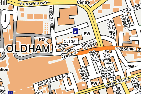
OL1 3AT lies on Church Terrace in Oldham. OL1 3AT is located in the St Mary's electoral ward, within the metropolitan district of Oldham and the English Parliamentary constituency of Oldham East and Saddleworth. The Sub Integrated Care Board (ICB) Location is NHS Greater Manchester ICB - 00Y and the police force is Greater Manchester. This postcode has been in use since January 1980.


GetTheData
Source: OS OpenMap – Local (Ordnance Survey)
Source: OS VectorMap District (Ordnance Survey)
Licence: Open Government Licence (requires attribution)
| Easting | 392688 |
| Northing | 405069 |
| Latitude | 53.542227 |
| Longitude | -2.111807 |
GetTheData
Source: Open Postcode Geo
Licence: Open Government Licence
| Street | Church Terrace |
| Town/City | Oldham |
| Country | England |
| Postcode District | OL1 |
➜ See where OL1 is on a map ➜ Where is Oldham? | |
GetTheData
Source: Land Registry Price Paid Data
Licence: Open Government Licence
Elevation or altitude of OL1 3AT as distance above sea level:
| Metres | Feet | |
|---|---|---|
| Elevation | 210m | 689ft |
Elevation is measured from the approximate centre of the postcode, to the nearest point on an OS contour line from OS Terrain 50, which has contour spacing of ten vertical metres.
➜ How high above sea level am I? Find the elevation of your current position using your device's GPS.
GetTheData
Source: Open Postcode Elevation
Licence: Open Government Licence
| Ward | St Mary's |
| Constituency | Oldham East And Saddleworth |
GetTheData
Source: ONS Postcode Database
Licence: Open Government Licence
| High St/Town Square (High St) | Oldham | 27m |
| High St/Lord St (High St) | Oldham | 39m |
| Lord St/Post Office (Lord St) | Oldham | 47m |
| Yorkshire St/St Mary's Way (Yorkshire St) | Oldham | 95m |
| Lord St/Sports Ctr (Lord St) | Oldham | 112m |
| Oldham Central (Manchester Metrolink) (Union St) | Oldham | 218m |
| Oldham King Street (Manchester Metrolink) (King St) | Oldham | 463m |
| Oldham Mumps (Manchester Metrolink) (Mumps) | Oldham Mumps | 555m |
| Westwood (Manchester Metrolink) (Middleton Road) | Westwood | 932m |
| Derker (Manchester Metrolink) (Yates Street) | Derker | 1,081m |
| Mills Hill (Manchester) Station | 4.1km |
| Moston Station | 4.4km |
| Mossley (Manchester) Station | 5.6km |
GetTheData
Source: NaPTAN
Licence: Open Government Licence
GetTheData
Source: ONS Postcode Database
Licence: Open Government Licence


➜ Get more ratings from the Food Standards Agency
GetTheData
Source: Food Standards Agency
Licence: FSA terms & conditions
| Last Collection | |||
|---|---|---|---|
| Location | Mon-Fri | Sat | Distance |
| Old Town Hall | 18:30 | 10:30 | 71m |
| Old Town Hall | 18:30 | 11:30 | 73m |
| Eldon Street | 16:50 | 11:20 | 388m |
GetTheData
Source: Dracos
Licence: Creative Commons Attribution-ShareAlike
The below table lists the International Territorial Level (ITL) codes (formerly Nomenclature of Territorial Units for Statistics (NUTS) codes) and Local Administrative Units (LAU) codes for OL1 3AT:
| ITL 1 Code | Name |
|---|---|
| TLD | North West (England) |
| ITL 2 Code | Name |
| TLD3 | Greater Manchester |
| ITL 3 Code | Name |
| TLD37 | Greater Manchester North East |
| LAU 1 Code | Name |
| E08000004 | Oldham |
GetTheData
Source: ONS Postcode Directory
Licence: Open Government Licence
The below table lists the Census Output Area (OA), Lower Layer Super Output Area (LSOA), and Middle Layer Super Output Area (MSOA) for OL1 3AT:
| Code | Name | |
|---|---|---|
| OA | E00027482 | |
| LSOA | E01005433 | Oldham 014D |
| MSOA | E02001111 | Oldham 014 |
GetTheData
Source: ONS Postcode Directory
Licence: Open Government Licence
| OL1 3AJ | High Street | 100m |
| OL1 1QN | Greaves Street | 110m |
| OL1 1QX | Yorkshire Street | 112m |
| OL1 3AG | Curzon Street | 129m |
| OL1 1SB | Yorkshire Street | 156m |
| OL1 1RD | Queen Street | 170m |
| OL1 1PF | Union Street | 181m |
| OL1 3BG | Albion Street | 182m |
| OL1 1HP | Peter Street | 190m |
| OL1 1SA | Retiro Street | 191m |
GetTheData
Source: Open Postcode Geo; Land Registry Price Paid Data
Licence: Open Government Licence