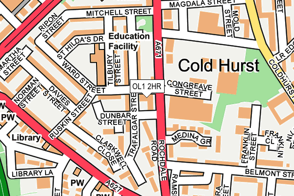
OL1 2HR is located in the Coldhurst electoral ward, within the metropolitan district of Oldham and the English Parliamentary constituency of Oldham West and Royton. The Sub Integrated Care Board (ICB) Location is NHS Greater Manchester ICB - 00Y and the police force is Greater Manchester. This postcode has been in use since July 1983.


GetTheData
Source: OS OpenMap – Local (Ordnance Survey)
Source: OS VectorMap District (Ordnance Survey)
Licence: Open Government Licence (requires attribution)
| Easting | 392113 |
| Northing | 405674 |
| Latitude | 53.547641 |
| Longitude | -2.120502 |
GetTheData
Source: Open Postcode Geo
Licence: Open Government Licence
| Country | England |
| Postcode District | OL1 |
➜ See where OL1 is on a map ➜ Where is Oldham? | |
GetTheData
Source: Land Registry Price Paid Data
Licence: Open Government Licence
Elevation or altitude of OL1 2HR as distance above sea level:
| Metres | Feet | |
|---|---|---|
| Elevation | 200m | 656ft |
Elevation is measured from the approximate centre of the postcode, to the nearest point on an OS contour line from OS Terrain 50, which has contour spacing of ten vertical metres.
➜ How high above sea level am I? Find the elevation of your current position using your device's GPS.
GetTheData
Source: Open Postcode Elevation
Licence: Open Government Licence
| Ward | Coldhurst |
| Constituency | Oldham West And Royton |
GetTheData
Source: ONS Postcode Database
Licence: Open Government Licence
| Rochdale Rd/Coldhurst St (Rochdale Rd) | Coldhurst | 101m |
| Rochdale Rd/Belmont St (Rochdale Rd) | Coldhurst | 119m |
| Rochdale Rd/Coldhurst St (Rochdale Rd) | Coldhurst | 157m |
| Rochdale Rd/Belmont St (Rochdale Rd) | Coldhurst | 181m |
| Chadderton Way/West End St (Chadderton Way) | Coldhurst | 186m |
| Westwood (Manchester Metrolink) (Middleton Road) | Westwood | 692m |
| Oldham King Street (Manchester Metrolink) (King St) | Oldham | 926m |
| Oldham Central (Manchester Metrolink) (Union St) | Oldham | 989m |
| Oldham Mumps (Manchester Metrolink) (Mumps) | Oldham Mumps | 1,273m |
| Derker (Manchester Metrolink) (Yates Street) | Derker | 1,274m |
| Mills Hill (Manchester) Station | 3.4km |
| Moston Station | 4.3km |
| Castleton (Manchester) Station | 6.2km |
GetTheData
Source: NaPTAN
Licence: Open Government Licence
GetTheData
Source: ONS Postcode Database
Licence: Open Government Licence


➜ Get more ratings from the Food Standards Agency
GetTheData
Source: Food Standards Agency
Licence: FSA terms & conditions
| Last Collection | |||
|---|---|---|---|
| Location | Mon-Fri | Sat | Distance |
| Oldham Delivery Office | 19:00 | 13:00 | 555m |
| Sheepfoot Lane | 17:30 | 11:15 | 745m |
| Old Town Hall | 18:30 | 10:30 | 904m |
GetTheData
Source: Dracos
Licence: Creative Commons Attribution-ShareAlike
The below table lists the International Territorial Level (ITL) codes (formerly Nomenclature of Territorial Units for Statistics (NUTS) codes) and Local Administrative Units (LAU) codes for OL1 2HR:
| ITL 1 Code | Name |
|---|---|
| TLD | North West (England) |
| ITL 2 Code | Name |
| TLD3 | Greater Manchester |
| ITL 3 Code | Name |
| TLD37 | Greater Manchester North East |
| LAU 1 Code | Name |
| E08000004 | Oldham |
GetTheData
Source: ONS Postcode Directory
Licence: Open Government Licence
The below table lists the Census Output Area (OA), Lower Layer Super Output Area (LSOA), and Middle Layer Super Output Area (MSOA) for OL1 2HR:
| Code | Name | |
|---|---|---|
| OA | E00027080 | |
| LSOA | E01005350 | Oldham 014B |
| MSOA | E02001111 | Oldham 014 |
GetTheData
Source: ONS Postcode Directory
Licence: Open Government Licence
| OL1 2HW | Trafalgar Street | 44m |
| OL1 2HX | Rochdale Road | 63m |
| OL1 2HL | Ward Street | 75m |
| OL1 2HN | Trafalgar Street | 80m |
| OL1 2HZ | Onslow Close | 104m |
| OL1 2HJ | Tilbury Street | 106m |
| OL1 2HY | Trafalgar Street | 113m |
| OL1 2EG | Ruskin Street | 146m |
| OL1 2DY | Rochdale Road | 154m |
| OL1 2EB | Clark Well Close | 155m |
GetTheData
Source: Open Postcode Geo; Land Registry Price Paid Data
Licence: Open Government Licence