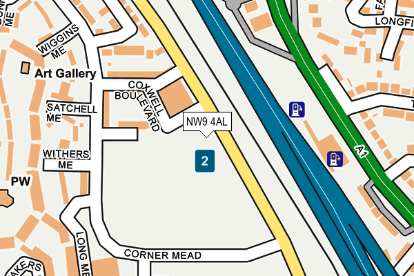
NW9 4AL is located in the Colindale North electoral ward, within the London borough of Barnet and the English Parliamentary constituency of Hendon. The Sub Integrated Care Board (ICB) Location is NHS North Central London ICB - 93C and the police force is Metropolitan Police. This postcode has been in use since July 2017.


GetTheData
Source: OS OpenMap – Local (Ordnance Survey)
Source: OS VectorMap District (Ordnance Survey)
Licence: Open Government Licence (requires attribution)
| Easting | 521843 |
| Northing | 190997 |
| Latitude | 51.604641 |
| Longitude | -0.241987 |
GetTheData
Source: Open Postcode Geo
Licence: Open Government Licence
| Country | England |
| Postcode District | NW9 |
➜ See where NW9 is on a map ➜ Where is London? | |
GetTheData
Source: Land Registry Price Paid Data
Licence: Open Government Licence
| Ward | Colindale North |
| Constituency | Hendon |
GetTheData
Source: ONS Postcode Database
Licence: Open Government Licence
| Wiggins Mead (Corner Mead) | Mill Hill | 124m |
| Barnet College (Corner Mead) | Colindale | 165m |
| Barnet College (Corner Mead) | Colindale | 197m |
| Wiggins Mead (Corner Mead) | Mill Hill | 199m |
| Pentavia Retail Park (Watford Way) | Mill Hill | 221m |
| Colindale Underground Station | Colindale | 1,162m |
| Mill Hill Broadway Station | 1.1km |
| Hendon Station | 2.7km |
| South Kenton Station | 6km |
GetTheData
Source: NaPTAN
Licence: Open Government Licence
| Percentage of properties with Next Generation Access | 100.0% |
| Percentage of properties with Superfast Broadband | 100.0% |
| Percentage of properties with Ultrafast Broadband | 100.0% |
| Percentage of properties with Full Fibre Broadband | 0.0% |
Superfast Broadband is between 30Mbps and 300Mbps
Ultrafast Broadband is > 300Mbps
| Median download speed | 100.0Mbps |
| Average download speed | 84.0Mbps |
| Maximum download speed | 200.00Mbps |
| Median upload speed | 0.4Mbps |
| Average upload speed | 0.5Mbps |
| Maximum upload speed | 0.78Mbps |
| Percentage of properties unable to receive 2Mbps | 0.0% |
| Percentage of properties unable to receive 5Mbps | 0.0% |
| Percentage of properties unable to receive 10Mbps | 0.0% |
| Percentage of properties unable to receive 30Mbps | 0.0% |
GetTheData
Source: Ofcom
Licence: Ofcom Terms of Use (requires attribution)
GetTheData
Source: ONS Postcode Database
Licence: Open Government Licence


➜ Get more ratings from the Food Standards Agency
GetTheData
Source: Food Standards Agency
Licence: FSA terms & conditions
| Last Collection | |||
|---|---|---|---|
| Location | Mon-Fri | Sat | Distance |
| Grahame Park Post Office | 17:30 | 12:00 | 295m |
| Grahame Park Way | 17:30 | 12:00 | 401m |
| Highlea Close | 17:30 | 12:00 | 429m |
GetTheData
Source: Dracos
Licence: Creative Commons Attribution-ShareAlike
The below table lists the International Territorial Level (ITL) codes (formerly Nomenclature of Territorial Units for Statistics (NUTS) codes) and Local Administrative Units (LAU) codes for NW9 4AL:
| ITL 1 Code | Name |
|---|---|
| TLI | London |
| ITL 2 Code | Name |
| TLI7 | Outer London - West and North West |
| ITL 3 Code | Name |
| TLI71 | Barnet |
| LAU 1 Code | Name |
| E09000003 | Barnet |
GetTheData
Source: ONS Postcode Directory
Licence: Open Government Licence
The below table lists the Census Output Area (OA), Lower Layer Super Output Area (LSOA), and Middle Layer Super Output Area (MSOA) for NW9 4AL:
| Code | Name | |
|---|---|---|
| OA | E00000736 | |
| LSOA | E01000152 | Barnet 026C |
| MSOA | E02000049 | Barnet 026 |
GetTheData
Source: ONS Postcode Directory
Licence: Open Government Licence
| NW9 5RR | Wiggins Mead | 163m |
| NW9 5RW | Satchell Mead | 170m |
| NW9 5RD | Corner Mead | 200m |
| NW9 5UE | Wiggins Mead | 208m |
| NW9 5RT | Wiggins Mead | 214m |
| NW7 2PX | Watford Way | 217m |
| NW9 5UH | Satchell Mead | 220m |
| NW9 5RU | Wiggins Mead | 221m |
| NW7 2SF | Aylesham Close | 233m |
| NW9 5UJ | Withers Mead | 234m |
GetTheData
Source: Open Postcode Geo; Land Registry Price Paid Data
Licence: Open Government Licence