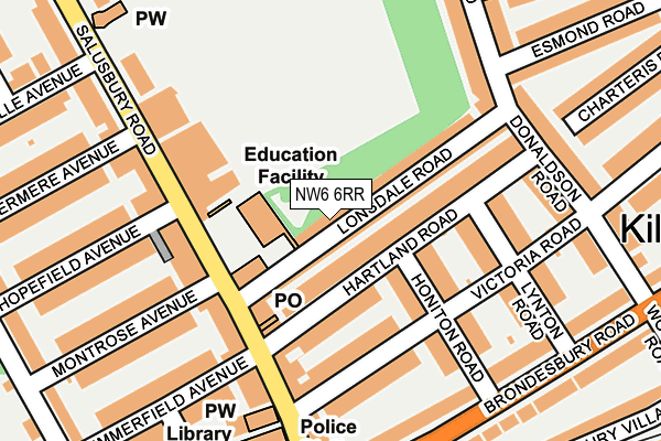
NW6 6RR is located in the Queens Park electoral ward, within the London borough of Brent and the English Parliamentary constituency of Hampstead and Kilburn. The Sub Integrated Care Board (ICB) Location is NHS North West London ICB - W2U3Z and the police force is Metropolitan Police. This postcode has been in use since July 1995.


GetTheData
Source: OS OpenMap – Local (Ordnance Survey)
Source: OS VectorMap District (Ordnance Survey)
Licence: Open Government Licence (requires attribution)
| Easting | 524627 |
| Northing | 183527 |
| Latitude | 51.536897 |
| Longitude | -0.204480 |
GetTheData
Source: Open Postcode Geo
Licence: Open Government Licence
| Country | England |
| Postcode District | NW6 |
➜ See where NW6 is on a map ➜ Where is London? | |
GetTheData
Source: Land Registry Price Paid Data
Licence: Open Government Licence
Elevation or altitude of NW6 6RR as distance above sea level:
| Metres | Feet | |
|---|---|---|
| Elevation | 40m | 131ft |
Elevation is measured from the approximate centre of the postcode, to the nearest point on an OS contour line from OS Terrain 50, which has contour spacing of ten vertical metres.
➜ How high above sea level am I? Find the elevation of your current position using your device's GPS.
GetTheData
Source: Open Postcode Elevation
Licence: Open Government Licence
| Ward | Queens Park |
| Constituency | Hampstead And Kilburn |
GetTheData
Source: ONS Postcode Database
Licence: Open Government Licence
| Queen's Park Stnvictoria Rd | Brondesbury Park | 195m |
| Queen's Park Stnvictoria Rd | Brondesbury Park | 210m |
| Brooksville Avenue | Brondesbury Park | 295m |
| Brooksville Avenue | Brondesbury Park | 300m |
| Woodville Road (Brondesbury Road) | Kilburn | 331m |
| Queen's Park Underground Station | Queen's Park | 305m |
| Kilburn Park Underground Station | Kilburn Park | 742m |
| Kilburn Underground Station | Brondesbury | 1,102m |
| West Hampstead Underground Station | West Hampstead | 1,428m |
| Maida Vale Underground Station | Maida Vale | 1,521m |
| Queens Park (London) Station | 0.3km |
| Brondesbury Park Station | 0.6km |
| Kilburn High Road Station | 0.9km |
GetTheData
Source: NaPTAN
Licence: Open Government Licence
GetTheData
Source: ONS Postcode Database
Licence: Open Government Licence


➜ Get more ratings from the Food Standards Agency
GetTheData
Source: Food Standards Agency
Licence: FSA terms & conditions
| Last Collection | |||
|---|---|---|---|
| Location | Mon-Fri | Sat | Distance |
| Salusbury Road Post Office | 18:30 | 12:00 | 129m |
| 108 Belsize Road | 17:30 | 12:00 | 129m |
| Brondesbury Road | 17:30 | 12:00 | 248m |
GetTheData
Source: Dracos
Licence: Creative Commons Attribution-ShareAlike
The below table lists the International Territorial Level (ITL) codes (formerly Nomenclature of Territorial Units for Statistics (NUTS) codes) and Local Administrative Units (LAU) codes for NW6 6RR:
| ITL 1 Code | Name |
|---|---|
| TLI | London |
| ITL 2 Code | Name |
| TLI7 | Outer London - West and North West |
| ITL 3 Code | Name |
| TLI72 | Brent |
| LAU 1 Code | Name |
| E09000005 | Brent |
GetTheData
Source: ONS Postcode Directory
Licence: Open Government Licence
The below table lists the Census Output Area (OA), Lower Layer Super Output Area (LSOA), and Middle Layer Super Output Area (MSOA) for NW6 6RR:
| Code | Name | |
|---|---|---|
| OA | E00002833 | |
| LSOA | E01000580 | Brent 032B |
| MSOA | E02000124 | Brent 032 |
GetTheData
Source: ONS Postcode Directory
Licence: Open Government Licence
| NW6 6BH | Hartland Road | 48m |
| NW6 6RA | Lonsdale Road | 58m |
| NW6 6BJ | Hartland Road | 86m |
| NW6 6QD | Honiton Road | 90m |
| NW6 6TE | Victoria Road | 121m |
| NW6 6BG | Hartland Road | 122m |
| NW6 6NH | Salusbury Road | 128m |
| NW6 6NR | Salusbury Road | 134m |
| NW6 6NU | Salusbury Road | 136m |
| NW6 6BL | Lynton Road | 136m |
GetTheData
Source: Open Postcode Geo; Land Registry Price Paid Data
Licence: Open Government Licence