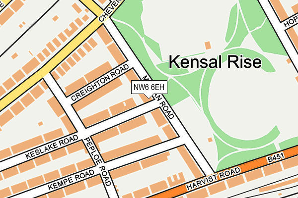
NW6 6EH lies on Milman Road in London. NW6 6EH is located in the Queens Park electoral ward, within the London borough of Brent and the English Parliamentary constituency of Hampstead and Kilburn. The Sub Integrated Care Board (ICB) Location is NHS North West London ICB - W2U3Z and the police force is Metropolitan Police. This postcode has been in use since January 1980.


GetTheData
Source: OS OpenMap – Local (Ordnance Survey)
Source: OS VectorMap District (Ordnance Survey)
Licence: Open Government Licence (requires attribution)
| Easting | 524053 |
| Northing | 183300 |
| Latitude | 51.534984 |
| Longitude | -0.212832 |
GetTheData
Source: Open Postcode Geo
Licence: Open Government Licence
| Street | Milman Road |
| Town/City | London |
| Country | England |
| Postcode District | NW6 |
➜ See where NW6 is on a map ➜ Where is London? | |
GetTheData
Source: Land Registry Price Paid Data
Licence: Open Government Licence
Elevation or altitude of NW6 6EH as distance above sea level:
| Metres | Feet | |
|---|---|---|
| Elevation | 40m | 131ft |
Elevation is measured from the approximate centre of the postcode, to the nearest point on an OS contour line from OS Terrain 50, which has contour spacing of ten vertical metres.
➜ How high above sea level am I? Find the elevation of your current position using your device's GPS.
GetTheData
Source: Open Postcode Elevation
Licence: Open Government Licence
| Ward | Queens Park |
| Constituency | Hampstead And Kilburn |
GetTheData
Source: ONS Postcode Database
Licence: Open Government Licence
| Allington Road (Kilburn Lane) | Queen's Park | 339m |
| Fifth Avenue (Kilburn Lane) | West Kilburn | 360m |
| Station Terrace (Chamberlayne Road) | Kensal Rise | 430m |
| Kensal Rise Station | Kensal Rise | 441m |
| Kensal Rise Station (Chamberlayne Road) | Kensal Rise | 458m |
| Queen's Park Underground Station | Queen's Park | 580m |
| Kensal Green Underground Station | Kensal Green | 979m |
| Kilburn Park Underground Station | Kilburn Park | 1,290m |
| Kilburn Underground Station | Brondesbury | 1,447m |
| West Hampstead Underground Station | West Hampstead | 1,990m |
| Kensal Rise Station | 0.5km |
| Queens Park (London) Station | 0.6km |
| Brondesbury Park Station | 0.7km |
GetTheData
Source: NaPTAN
Licence: Open Government Licence
| Percentage of properties with Next Generation Access | 100.0% |
| Percentage of properties with Superfast Broadband | 100.0% |
| Percentage of properties with Ultrafast Broadband | 100.0% |
| Percentage of properties with Full Fibre Broadband | 0.0% |
Superfast Broadband is between 30Mbps and 300Mbps
Ultrafast Broadband is > 300Mbps
| Percentage of properties unable to receive 2Mbps | 0.0% |
| Percentage of properties unable to receive 5Mbps | 0.0% |
| Percentage of properties unable to receive 10Mbps | 0.0% |
| Percentage of properties unable to receive 30Mbps | 0.0% |
GetTheData
Source: Ofcom
Licence: Ofcom Terms of Use (requires attribution)
GetTheData
Source: ONS Postcode Database
Licence: Open Government Licence


➜ Get more ratings from the Food Standards Agency
GetTheData
Source: Food Standards Agency
Licence: FSA terms & conditions
| Last Collection | |||
|---|---|---|---|
| Location | Mon-Fri | Sat | Distance |
| Harvist Road | 17:30 | 12:00 | 206m |
| Peploe Road | 17:30 | 12:00 | 206m |
| Hopefield Avenue | 17:30 | 12:00 | 331m |
GetTheData
Source: Dracos
Licence: Creative Commons Attribution-ShareAlike
The below table lists the International Territorial Level (ITL) codes (formerly Nomenclature of Territorial Units for Statistics (NUTS) codes) and Local Administrative Units (LAU) codes for NW6 6EH:
| ITL 1 Code | Name |
|---|---|
| TLI | London |
| ITL 2 Code | Name |
| TLI7 | Outer London - West and North West |
| ITL 3 Code | Name |
| TLI72 | Brent |
| LAU 1 Code | Name |
| E09000005 | Brent |
GetTheData
Source: ONS Postcode Directory
Licence: Open Government Licence
The below table lists the Census Output Area (OA), Lower Layer Super Output Area (LSOA), and Middle Layer Super Output Area (MSOA) for NW6 6EH:
| Code | Name | |
|---|---|---|
| OA | E00002844 | |
| LSOA | E01000582 | Brent 032C |
| MSOA | E02000124 | Brent 032 |
GetTheData
Source: ONS Postcode Directory
Licence: Open Government Licence
| NW6 6EJ | Milman Road | 45m |
| NW6 6EL | Milman Road | 71m |
| NW6 6DL | Keslake Road | 89m |
| NW6 6DJ | Keslake Road | 91m |
| NW6 6EG | Milman Road | 92m |
| NW6 6EE | Creighton Road | 109m |
| NW6 6SJ | Kempe Road | 111m |
| NW6 6ED | Creighton Road | 128m |
| NW6 6EN | Milman Road | 131m |
| NW6 6SP | Kempe Road | 132m |
GetTheData
Source: Open Postcode Geo; Land Registry Price Paid Data
Licence: Open Government Licence